![](/images/other/stat-length.png)
![Randonnée Marche Les Deux Alpes - Lac Lauvitel (Vénosc - Isère) 11/07/2020 à 09:26 - Photo](https://media.geolcdn.com/t/1900/400/83c7e7f2-213d-4f88-86a5-3b3cfb2a9709.jpg&format=pjpeg&maxdim=2)
Lac Lauvitel (Vénosc - Isère) 11/07/2020 à 09:26
Jfumomo
Utilisateur
![Longueur](/images/other/stat-length.png)
![Altitude max](https://static1.geolcdn.com/siteimages/upload/files/1508320355ic_sort_altitude_max_24dp.png)
![Dénivelé positif](https://static1.geolcdn.com/siteimages/upload/files/1508320355ic_sort_den_pos_24dp.png)
![Km-Effort](/images/other/stat-length.png)
![Altitude min](https://static1.geolcdn.com/siteimages/upload/files/1508320355ic_sort_altitude_min_24dp.png)
![Dénivelé négatif](https://static1.geolcdn.com/siteimages/upload/files/1508320355ic_sort_den_neg_24dp.png)
![Boucle](https://static1.geolcdn.com/siteimages/upload/files/16400158638029165_repeat_loop_refresh_sync_direction_icon.png)
![Marche](https://static1.geolcdn.com/sitytour/trail-icons/101.png)
3h15
Difficulté : Moyen
![Scannez ce code QR pour ouvrir la randonnée dans l'application SityTrail](https://capi.geolives.com/qq0zvz2zws4bq2lad0pu/sitytour/trails/2475737/qr.png?size=200)
Application GPS de randonnée GRATUITE
À propos
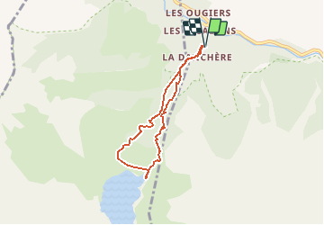
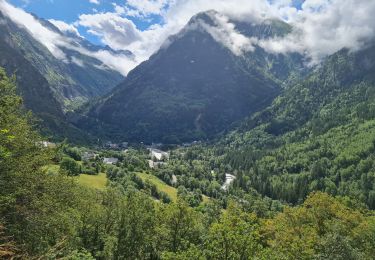
Randonnée Marche de 5,9 km à découvrir à Auvergne-Rhône-Alpes, Isère, Les Deux Alpes. Cette randonnée est proposée par Jfumomo.
Description
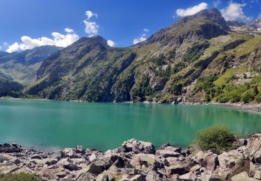
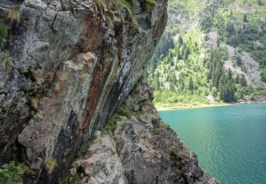
Le Lac du Lauvitel est le plus grand lac du massif des Écrins.
Première Réserve Intégrale de France créée au sein d'un parc national. Celle-ci a vu le jour le 9 mai 1995 et fait partie du territoire
de la commune du Bourg d'Oisans. Cet espace de protection renforcée se situe au Sud du vallon du Lauvitel en amont du lac.
D'accès difficile et dangereux, il ne s'exerce plus aucune activité humaine depuis plus de 50 ans, ce qui permet d'effectuer des études
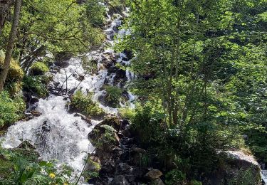
Localisation
Commentaires
Randonnées à proximité
![Randonnée Marche Les Deux Alpes - Lac Lauvitel depuis Venosc - Photo](https://media.geolcdn.com/t/375/260/c143dd5b-9bc9-4aa4-a71f-cc60077c341b.jpg&format=jpg&maxdim=2)
![Marche Marche](https://static1.geolcdn.com/sitytour/trail-icons/101.png)
Marche
![](/images/other/stat-length.png)
![](https://static1.geolcdn.com/siteimages/upload/files/16400158638029165_repeat_loop_refresh_sync_direction_icon.png)
![Randonnée Marche Les Deux Alpes - 2020-09-01 Marche Tour de l'Aiguille de Venosc (2 jours) - Photo](https://media.geolcdn.com/t/375/260/34a6bca9-af34-47ba-b9a3-4e85df680f5f.jpg&format=jpg&maxdim=2)
![Marche Marche](https://static1.geolcdn.com/sitytour/trail-icons/101.png)
Marche
![](/images/other/stat-length.png)
![](https://static1.geolcdn.com/siteimages/upload/files/16400158638029165_repeat_loop_refresh_sync_direction_icon.png)
![Randonnée Marche Les Deux Alpes - 2020-09-02 Marche Refuge Muzelle Lac Lauvitel Venosc - Photo](https://media.geolcdn.com/t/375/260/c75743e1-22bd-4dec-87c4-57455ba46347.jpg&format=jpg&maxdim=2)
![Marche Marche](https://static1.geolcdn.com/sitytour/trail-icons/101.png)
Marche
![](/images/other/stat-length.png)
![](https://static1.geolcdn.com/siteimages/upload/files/16400158638029165_repeat_loop_refresh_sync_direction_icon.png)
![Randonnée Marche Les Deux Alpes - 2020-09-01 Marche Venosc Refuge et lac de la Muzelle - Photo](https://media.geolcdn.com/t/375/260/37e869b2-5bed-4bce-85a1-f553a21d8058.jpg&format=jpg&maxdim=2)
![Marche Marche](https://static1.geolcdn.com/sitytour/trail-icons/101.png)
Marche
![](/images/other/stat-length.png)
![](https://static1.geolcdn.com/siteimages/upload/files/16400158638029165_repeat_loop_refresh_sync_direction_icon.png)
![Randonnée Marche Les Deux Alpes - Les Deux Alpes - de La Danchère au Lac Lauvitel - 9.3km 590m 6h10 (1h10) - 2015 06 22 - Photo](https://media.geolcdn.com/t/375/260/ext.jpg?maxdim=2&url=https%3A%2F%2Fservices.sitytrail.com%2FGeolivesWS%2FDownloadMedia.ashx%3FTrailID%3D437032%26Media%3Dfix__20150622133152.jpg)
![Marche Marche](https://static1.geolcdn.com/sitytour/trail-icons/101.png)
Marche
![](/images/other/stat-length.png)
![](https://static1.geolcdn.com/siteimages/upload/files/16400158638029165_repeat_loop_refresh_sync_direction_icon.png)
![Randonnée Marche Les Deux Alpes - Ferraret village du Venosc - Photo](https://media.geolcdn.com/t/375/260/16333e30-f56d-457a-acb2-97a1c2e77d5f.jpg&format=jpg&maxdim=2)
![Marche Marche](https://static1.geolcdn.com/sitytour/trail-icons/101.png)
Marche
![](/images/other/stat-length.png)
![](https://static1.geolcdn.com/siteimages/upload/files/16400158638029165_repeat_loop_refresh_sync_direction_icon.png)
![Randonnée Marche Les Deux Alpes - Lac lauvitel e boucle descente par le GR trace réelle - Photo](https://media.geolcdn.com/t/375/260/d0c34587-c72a-43b6-9009-378bbac0bd3c.jpg&format=jpg&maxdim=2)
![Marche Marche](https://static1.geolcdn.com/sitytour/trail-icons/101.png)
Marche
![](/images/other/stat-length.png)
![](https://static1.geolcdn.com/siteimages/upload/files/16400158638029165_repeat_loop_refresh_sync_direction_icon.png)
![Randonnée Marche Les Deux Alpes - Venise le lauvitel - Photo](https://media.geolcdn.com/t/375/260/04546b3c-8a5a-43b8-a9f0-58cff4d320ee.jpg&format=jpg&maxdim=2)
![Marche Marche](https://static1.geolcdn.com/sitytour/trail-icons/101.png)
Marche
![](/images/other/stat-length.png)
![](https://static1.geolcdn.com/siteimages/upload/files/16400158638029165_repeat_loop_refresh_sync_direction_icon.png)
![Randonnée Marche Les Deux Alpes - lac du Lauvitel - Photo](https://media.geolcdn.com/t/375/260/c2a1bd54-0be4-42a2-bb7e-efc3dcc25eb3.jpg&format=jpg&maxdim=2)
![Marche Marche](https://static1.geolcdn.com/sitytour/trail-icons/101.png)
Marche
![](/images/other/stat-length.png)
![](https://static1.geolcdn.com/siteimages/upload/files/16400158638029165_repeat_loop_refresh_sync_direction_icon.png)