![](/images/other/stat-length.png)
![Randonnée Vélo de route Ville de Bruxelles - Autour de Wemmel - Photo](https://media.geolcdn.com/t/1900/400/ext.pjpeg?maxdim=2&url=https%3A%2F%2Fstatic1.geolcdn.com%2Fsiteimages%2Fupload%2Ffiles%2F1524743154velo.jpg)
Autour de Wemmel
decateric
Utilisateur
![Longueur](/images/other/stat-length.png)
Longueur
41 km
![Altitude max](https://static1.geolcdn.com/siteimages/upload/files/1508320355ic_sort_altitude_max_24dp.png)
Altitude max
95 m
![Dénivelé positif](https://static1.geolcdn.com/siteimages/upload/files/1508320355ic_sort_den_pos_24dp.png)
Dénivelé positif
416 m
![Km-Effort](/images/other/stat-length.png)
Km-Effort
46 km
![Altitude min](https://static1.geolcdn.com/siteimages/upload/files/1508320355ic_sort_altitude_min_24dp.png)
Altitude min
15 m
![Dénivelé négatif](https://static1.geolcdn.com/siteimages/upload/files/1508320355ic_sort_den_neg_24dp.png)
Dénivelé négatif
382 m
![Boucle](https://static1.geolcdn.com/siteimages/upload/files/16400158638029165_repeat_loop_refresh_sync_direction_icon.png)
Boucle
Non
Date de création :
2020-07-12 12:41:36.0
Dernière modification :
2020-07-12 16:18:38.082
![Vélo de route](https://static1.geolcdn.com/sitytour/trail-icons/201.png)
2h31
Difficulté : Moyen
![Scannez ce code QR pour ouvrir la randonnée dans l'application SityTrail](https://capi.geolives.com/qq0zvz2zws4bq2lad0pu/sitytour/trails/2472577/qr.png?size=200)
Application GPS de randonnée GRATUITE
À propos
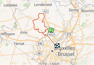
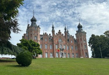
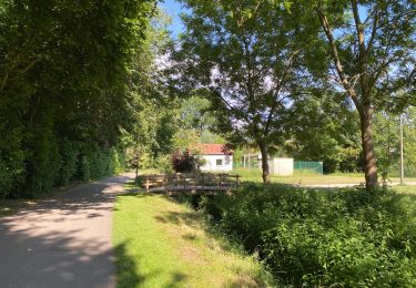
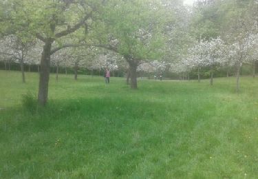
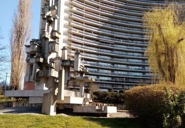
Randonnée Vélo de route de 41 km à découvrir à Bruxelles-Capitale, Inconnu, Ville de Bruxelles. Cette randonnée est proposée par decateric.
Description
Partir métro Roi Baudouin. Tour très agréable souvent par des petits sentiers et pas beaucoup de dénivelé. 2h30 à une moyenne de 13km/h.
Localisation
Pays :
Belgique
Région :
Bruxelles-Capitale
Département/Province :
Inconnu
Commune :
Ville de Bruxelles
Localité :
Laeken
Départ:(Dec)
Départ:(UTM)
593385 ; 5639238 (31U) N.
Commentaires
Randonnées à proximité
![Randonnée Marche Saint-Josse-ten-Noode - RB-Br-12 - Photo](https://media.geolcdn.com/t/375/260/ext.jpg?maxdim=2&url=https%3A%2F%2Fservices.sitytrail.com%2FGeolivesWS%2FDownloadMedia.ashx%3FTrailID%3D247909%26Media%3D1e73b1c1-685b-4b18-8885-19b8987940e4.jpg)
![Marche Marche](https://static1.geolcdn.com/sitytour/trail-icons/101.png)
RB-Br-12
Marche
Facile
(5)
Saint-Josse-ten-Noode,
Bruxelles-Capitale,
Inconnu,
Belgique
![](/images/other/stat-length.png)
12,8 km | 15,1 km-effort
3h 26min
![](https://static1.geolcdn.com/siteimages/upload/files/16400158638029165_repeat_loop_refresh_sync_direction_icon.png)
Oui
![Randonnée Marche Grimbergen - Grimbergen 8 km - Photo](https://media.geolcdn.com/t/375/260/b35b3f1b-a699-43d6-969b-1639eabce32f.jpg&format=jpg&maxdim=2)
![Marche Marche](https://static1.geolcdn.com/sitytour/trail-icons/101.png)
Grimbergen 8 km
Marche
Moyen
(5)
Grimbergen,
Flandre,
Brabant flamand,
Belgique
![](/images/other/stat-length.png)
8,1 km | 8,6 km-effort
1h 23min
![](https://static1.geolcdn.com/siteimages/upload/files/16400158638029165_repeat_loop_refresh_sync_direction_icon.png)
Non
![Randonnée Marche Jette - RB-Br-03_Les-plateaux-du-nord-ouest - Photo](https://media.geolcdn.com/t/375/260/ext.jpg?maxdim=2&url=https%3A%2F%2Fservices.sitytrail.com%2FGeolivesWS%2FDownloadMedia.ashx%3FTrailID%3D247875%26Media%3D148492a9-407c-49a4-a3b7-d7d8d6aa5fa9.jpg)
![Marche Marche](https://static1.geolcdn.com/sitytour/trail-icons/101.png)
RB-Br-03_Les-plateaux-du-nord-ouest
Marche
Très difficile
(2)
Jette,
Bruxelles-Capitale,
Inconnu,
Belgique
![](/images/other/stat-length.png)
25 km | 29 km-effort
6h 38min
![](https://static1.geolcdn.com/siteimages/upload/files/16400158638029165_repeat_loop_refresh_sync_direction_icon.png)
Oui
![Randonnée Marche Ville de Bruxelles - RB-Br-02 - Photo](https://media.geolcdn.com/t/375/260/ext.jpg?maxdim=2&url=https%3A%2F%2Fservices.sitytrail.com%2FGeolivesWS%2FDownloadMedia.ashx%3FTrailID%3D247873%26Media%3Ddfaf2d4a-e0b3-4c36-97b5-3b14c6762b25.jpg)
![Marche Marche](https://static1.geolcdn.com/sitytour/trail-icons/101.png)
RB-Br-02
Marche
Moyen
(1)
Ville de Bruxelles,
Bruxelles-Capitale,
Inconnu,
Belgique
![](/images/other/stat-length.png)
21 km | 24 km-effort
5h 32min
![](https://static1.geolcdn.com/siteimages/upload/files/16400158638029165_repeat_loop_refresh_sync_direction_icon.png)
Oui
![Randonnée Marche Ville de Bruxelles - RB-Br-01 Rac01 - Photo](https://media.geolcdn.com/t/375/260/ext.jpg?maxdim=2&url=https%3A%2F%2Fservices.sitytrail.com%2FGeolivesWS%2FDownloadMedia.ashx%3FTrailID%3D247871%26Media%3Dc4587231-2ae7-41fa-9d29-8fa1efb02129.jpg)
![Marche Marche](https://static1.geolcdn.com/sitytour/trail-icons/101.png)
RB-Br-01 Rac01
Marche
Facile
(3)
Ville de Bruxelles,
Bruxelles-Capitale,
Inconnu,
Belgique
![](/images/other/stat-length.png)
16 km | 19 km-effort
4h 19min
![](https://static1.geolcdn.com/siteimages/upload/files/16400158638029165_repeat_loop_refresh_sync_direction_icon.png)
Oui
![Marche Marche](https://static1.geolcdn.com/sitytour/trail-icons/101.png)
#230714 - Dilbeek, Kattenberg, Rés. Nat. Wolfsputten**
Marche
Moyen
(1)
Dilbeek,
Flandre,
Brabant flamand,
Belgique
![](/images/other/stat-length.png)
5,1 km | 6,2 km-effort
1h 24min
![](https://static1.geolcdn.com/siteimages/upload/files/16400158638029165_repeat_loop_refresh_sync_direction_icon.png)
Oui
![Randonnée Marche Wemmel - Wemmel Beverbos 6 km - Photo](https://media.geolcdn.com/t/375/260/3be3b710-42f6-4600-9f48-b1342818e945.jpg&format=jpg&maxdim=2)
![Marche Marche](https://static1.geolcdn.com/sitytour/trail-icons/101.png)
Wemmel Beverbos 6 km
Marche
Moyen
(2)
Wemmel,
Flandre,
Brabant flamand,
Belgique
![](/images/other/stat-length.png)
6,7 km | 7,6 km-effort
1h 32min
![](https://static1.geolcdn.com/siteimages/upload/files/16400158638029165_repeat_loop_refresh_sync_direction_icon.png)
Oui
![Randonnée Vélo Ville de Bruxelles - Atomium à Atlas - Photo](https://media.geolcdn.com/t/375/260/ext.jpg?maxdim=2&url=https%3A%2F%2Fservices.sitytrail.com%2FGeolivesWS%2FDownloadMedia.ashx%3FTrailID%3D190938%26Media%3D20130510152551.jpeg)
![Vélo Vélo](https://static1.geolcdn.com/sitytour/trail-icons/200.png)
Atomium à Atlas
Vélo
Moyen
(1)
Ville de Bruxelles,
Bruxelles-Capitale,
Inconnu,
Belgique
![](/images/other/stat-length.png)
45 km | 52 km-effort
2h 58min
![](https://static1.geolcdn.com/siteimages/upload/files/16400158638029165_repeat_loop_refresh_sync_direction_icon.png)
Non
![Randonnée Marche Berchem-Sainte-Agathe - Molenbeek vert 1 - Photo](https://media.geolcdn.com/t/375/260/beb9cc6b-2ce6-4f36-acea-34847e0cf6e9.jpg&format=jpg&maxdim=2)
![Marche Marche](https://static1.geolcdn.com/sitytour/trail-icons/101.png)
Molenbeek vert 1
Marche
Très facile
(1)
Berchem-Sainte-Agathe,
Bruxelles-Capitale,
Inconnu,
Belgique
![](/images/other/stat-length.png)
8,3 km | 9,5 km-effort
1h 55min
![](https://static1.geolcdn.com/siteimages/upload/files/16400158638029165_repeat_loop_refresh_sync_direction_icon.png)
Non