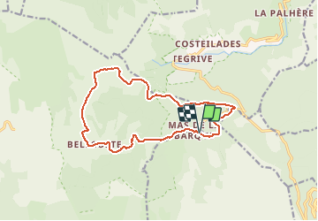
![](/images/other/stat-length.png)
![Randonnée Marche Vialas - Pic cassini 130720 - Photo](https://media.geolcdn.com/t/1900/400/742a94c6-6c6b-4707-8fb1-06c4a7430aab.png&format=pjpeg&maxdim=2)
Pic cassini 130720
fario
Utilisateur
![Longueur](/images/other/stat-length.png)
![Altitude max](https://static1.geolcdn.com/siteimages/upload/files/1508320355ic_sort_altitude_max_24dp.png)
![Dénivelé positif](https://static1.geolcdn.com/siteimages/upload/files/1508320355ic_sort_den_pos_24dp.png)
![Km-Effort](/images/other/stat-length.png)
![Altitude min](https://static1.geolcdn.com/siteimages/upload/files/1508320355ic_sort_altitude_min_24dp.png)
![Dénivelé négatif](https://static1.geolcdn.com/siteimages/upload/files/1508320355ic_sort_den_neg_24dp.png)
![Boucle](https://static1.geolcdn.com/siteimages/upload/files/16400158638029165_repeat_loop_refresh_sync_direction_icon.png)
![Marche](https://static1.geolcdn.com/sitytour/trail-icons/101.png)
4h22
Difficulté : Très difficile
![Scannez ce code QR pour ouvrir la randonnée dans l'application SityTrail](https://capi.geolives.com/qq0zvz2zws4bq2lad0pu/sitytour/trails/2470856/qr.png?size=200)
Application GPS de randonnée GRATUITE
À propos
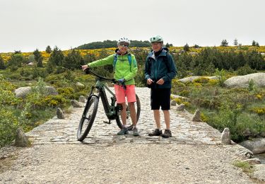
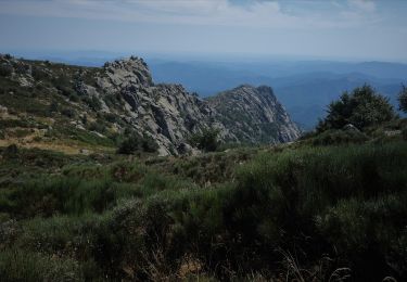
Randonnée Marche de 14,8 km à découvrir à Occitanie, Lozère, Vialas. Cette randonnée est proposée par fario.
Description
Belle rando*** au départ du mas de la barque. La piste de Bellecoste est très agréable de bon matin. Puis nous montons au Pic Casini, ou il y a un peu de monde. Nous avons presque froid après la suée de la montée. Descente au travers des bois sur le mas de la barque. La rando dans ce sens est très bien. Un beau cèpe dans les bois.
Localisation
Commentaires
Randonnées à proximité
![Randonnée Marche Pont de Montvert - Sud Mont Lozère - Pic Cassini - Photo](https://media.geolcdn.com/t/375/260/b7ddaced-bcb0-4b32-b249-2c8e50e8defa.jpg&format=jpg&maxdim=2)
![Marche Marche](https://static1.geolcdn.com/sitytour/trail-icons/101.png)
Marche
![](/images/other/stat-length.png)
![](https://static1.geolcdn.com/siteimages/upload/files/16400158638029165_repeat_loop_refresh_sync_direction_icon.png)
![Randonnée Marche Pont de Montvert - Sud Mont Lozère - Sources du Tarn - Photo](https://media.geolcdn.com/t/375/260/9fb93292-7a78-48e0-a178-bcdaaf22ee73.jpg&format=jpg&maxdim=2)
![Marche Marche](https://static1.geolcdn.com/sitytour/trail-icons/101.png)
Marche
![](/images/other/stat-length.png)
![](https://static1.geolcdn.com/siteimages/upload/files/16400158638029165_repeat_loop_refresh_sync_direction_icon.png)
![Randonnée Marche Concoules - La Virado del Ronc - Photo](https://media.geolcdn.com/t/375/260/ext.jpg?maxdim=2&url=https%3A%2F%2Fstatic1.geolcdn.com%2Fsiteimages%2Fupload%2Ffiles%2F1553511878bg_sport_marche.png)
![Marche Marche](https://static1.geolcdn.com/sitytour/trail-icons/101.png)
Marche
![](/images/other/stat-length.png)
![](https://static1.geolcdn.com/siteimages/upload/files/16400158638029165_repeat_loop_refresh_sync_direction_icon.png)
![Randonnée sport Vialas - Promenade autour du Mas de La Barque - Photo](https://media.geolcdn.com/t/375/260/4e9f8f81-f986-4a22-abe2-923e901965f6.jpg&format=jpg&maxdim=2)
sport
![](/images/other/stat-length.png)
![](https://static1.geolcdn.com/siteimages/upload/files/16400158638029165_repeat_loop_refresh_sync_direction_icon.png)
![Randonnée sport Vialas - Le pont du Tarn - Photo](https://media.geolcdn.com/t/375/260/77974779-cb5d-4643-91a9-e53d91d38c3b.jpg&format=jpg&maxdim=2)
sport
![](/images/other/stat-length.png)
![](https://static1.geolcdn.com/siteimages/upload/files/16400158638029165_repeat_loop_refresh_sync_direction_icon.png)
![Randonnée Marche Pont de Montvert - Sud Mont Lozère - Le Pic Cassini - Photo](https://media.geolcdn.com/t/375/260/f1564082-1b31-405a-b468-2ba69c236589.jpg&format=jpg&maxdim=2)
![Marche Marche](https://static1.geolcdn.com/sitytour/trail-icons/101.png)
Marche
![](/images/other/stat-length.png)
![](https://static1.geolcdn.com/siteimages/upload/files/16400158638029165_repeat_loop_refresh_sync_direction_icon.png)
![Randonnée Marche Concoules - Mont Lozère au départ de Concoules - Photo](https://media.geolcdn.com/t/375/260/e8e04d59-7cd7-497b-bb8a-e594db86e8bf.jpg&format=jpg&maxdim=2)
![Marche Marche](https://static1.geolcdn.com/sitytour/trail-icons/101.png)
Marche
![](/images/other/stat-length.png)
![](https://static1.geolcdn.com/siteimages/upload/files/16400158638029165_repeat_loop_refresh_sync_direction_icon.png)
![Randonnée Marche Concoules - Conclûmes - Photo](https://media.geolcdn.com/t/375/260/976d86f2-d295-41c3-ab9d-ca7d48a522da.jpg&format=jpg&maxdim=2)
![Marche Marche](https://static1.geolcdn.com/sitytour/trail-icons/101.png)
Marche
![](/images/other/stat-length.png)
![](https://static1.geolcdn.com/siteimages/upload/files/16400158638029165_repeat_loop_refresh_sync_direction_icon.png)
![Marche Marche](https://static1.geolcdn.com/sitytour/trail-icons/101.png)
Marche
![](/images/other/stat-length.png)
![](https://static1.geolcdn.com/siteimages/upload/files/16400158638029165_repeat_loop_refresh_sync_direction_icon.png)