![](/images/other/stat-length.png)
![Randonnée Marche nordique Vieux Brisach - TSP - Etude MN 11/07/2020 - Breisach - Photo](https://media.geolcdn.com/t/1900/400/ext.pjpeg?maxdim=2&url=https%3A%2F%2Fstatic1.geolcdn.com%2Fsiteimages%2Fupload%2Ffiles%2F1545311037marcheuse_200dpi.jpg)
TSP - Etude MN 11/07/2020 - Breisach
Hub6877
Utilisateur
![Longueur](/images/other/stat-length.png)
Longueur
7,8 km
![Altitude max](https://static1.geolcdn.com/siteimages/upload/files/1508320355ic_sort_altitude_max_24dp.png)
Altitude max
201 m
![Dénivelé positif](https://static1.geolcdn.com/siteimages/upload/files/1508320355ic_sort_den_pos_24dp.png)
Dénivelé positif
62 m
![Km-Effort](/images/other/stat-length.png)
Km-Effort
8,7 km
![Altitude min](https://static1.geolcdn.com/siteimages/upload/files/1508320355ic_sort_altitude_min_24dp.png)
Altitude min
180 m
![Dénivelé négatif](https://static1.geolcdn.com/siteimages/upload/files/1508320355ic_sort_den_neg_24dp.png)
Dénivelé négatif
63 m
![Boucle](https://static1.geolcdn.com/siteimages/upload/files/16400158638029165_repeat_loop_refresh_sync_direction_icon.png)
Boucle
Oui
Date de création :
2020-07-11 08:25:07.122
Dernière modification :
2020-09-19 16:59:16.089
![Marche nordique](https://static1.geolcdn.com/sitytour/trail-icons/102.png)
--
Difficulté : Facile
![Scannez ce code QR pour ouvrir la randonnée dans l'application SityTrail](https://capi.geolives.com/qq0zvz2zws4bq2lad0pu/sitytour/trails/2470268/qr.png?size=200)
Application GPS de randonnée GRATUITE
À propos
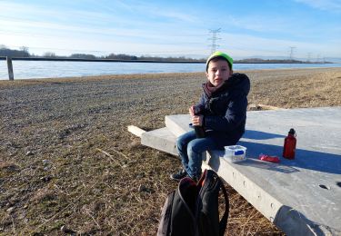
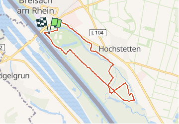
Randonnée Marche nordique de 7,8 km à découvrir à Bade-Wurtemberg, Arrondissement de Brisgau-Haute-Forêt-Noire, Vieux Brisach. Cette randonnée est proposée par Hub6877.
Description
Tracé Sur Plan établi à partir de la proposition Sity Trail de "Hérisson matin" et modifié par mes soins.
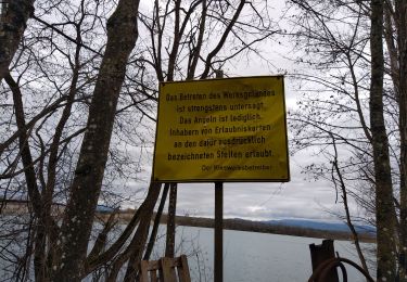
La reconnaissance sur le terrain a été effectuée par mes soins le 11/09/2020 - Voir n°
Localisation
Pays :
Allemagne
Région :
Bade-Wurtemberg
Département/Province :
Arrondissement de Brisgau-Haute-Forêt-Noire
Commune :
Vieux Brisach
Localité :
Unknown
Départ:(Dec)
Départ:(UTM)
394532 ; 5319763 (32U) N.
Commentaires
Randonnées à proximité
![Randonnée A pied Ihringen - Bienenfresserpfad - Photo](https://media.geolcdn.com/t/375/260/ext.jpg?maxdim=2&url=https%3A%2F%2Fmedia.geolcdn.com%2Ff%2F6adf0c79-1772-42f2-a9eb-4c242740bd7c.jpeg)
![A pied A pied](https://static1.geolcdn.com/sitytour/trail-icons/100.png)
Bienenfresserpfad
A pied
Moyen
Ihringen,
Bade-Wurtemberg,
Arrondissement de Brisgau-Haute-Forêt-Noire,
Allemagne
![](/images/other/stat-length.png)
19 km | 26 km-effort
5h 49min
![](https://static1.geolcdn.com/siteimages/upload/files/16400158638029165_repeat_loop_refresh_sync_direction_icon.png)
Non
![Randonnée A pied Ihringen - Kaiserstuhlpfad - Photo](https://media.geolcdn.com/t/375/260/ext.jpg?maxdim=2&url=https%3A%2F%2Fmedia.geolcdn.com%2Ff%2F6adf0c79-1772-42f2-a9eb-4c242740bd7c.jpeg)
![A pied A pied](https://static1.geolcdn.com/sitytour/trail-icons/100.png)
Kaiserstuhlpfad
A pied
Facile
Ihringen,
Bade-Wurtemberg,
Arrondissement de Brisgau-Haute-Forêt-Noire,
Allemagne
![](/images/other/stat-length.png)
4,6 km | 5,9 km-effort
1h 20min
![](https://static1.geolcdn.com/siteimages/upload/files/16400158638029165_repeat_loop_refresh_sync_direction_icon.png)
Non
![Randonnée Marche Vogelgrun - vogel - Photo](https://media.geolcdn.com/t/375/260/ext.jpg?maxdim=2&url=https%3A%2F%2Fmedia.geolcdn.com%2Ff%2F3008eac2-508d-40d7-bd73-6be5707e293b.jpg)
![Marche Marche](https://static1.geolcdn.com/sitytour/trail-icons/101.png)
vogel
Marche
Difficile
Vogelgrun,
Grand Est,
Haut-Rhin,
France
![](/images/other/stat-length.png)
15,7 km | 17,8 km-effort
20h 19min
![](https://static1.geolcdn.com/siteimages/upload/files/16400158638029165_repeat_loop_refresh_sync_direction_icon.png)
Oui
![Randonnée Marche Vogelgrun - vogelgrun - Photo](https://media.geolcdn.com/t/375/260/ext.jpg?maxdim=2&url=https%3A%2F%2Fmedia.geolcdn.com%2Ff%2Fac5f8593-d6b6-45da-9d2a-d10b1edc2d80.jpg)
![Marche Marche](https://static1.geolcdn.com/sitytour/trail-icons/101.png)
vogelgrun
Marche
Difficile
Vogelgrun,
Grand Est,
Haut-Rhin,
France
![](/images/other/stat-length.png)
15,5 km | 17,7 km-effort
4h 8min
![](https://static1.geolcdn.com/siteimages/upload/files/16400158638029165_repeat_loop_refresh_sync_direction_icon.png)
Oui
![Randonnée Marche Vogtsbourg - ARCA - Photo](https://media.geolcdn.com/t/375/260/ext.jpg?maxdim=2&url=https%3A%2F%2Fmedia.geolcdn.com%2Ff%2F2bd0409e-4d25-46b7-8d70-dc55faee2ab2.jpg)
![Marche Marche](https://static1.geolcdn.com/sitytour/trail-icons/101.png)
ARCA
Marche
Facile
Vogtsbourg,
Bade-Wurtemberg,
Arrondissement de Brisgau-Haute-Forêt-Noire,
Allemagne
![](/images/other/stat-length.png)
12,9 km | 18,4 km-effort
5h 33min
![](https://static1.geolcdn.com/siteimages/upload/files/16400158638029165_repeat_loop_refresh_sync_direction_icon.png)
Oui
![Randonnée Cyclotourisme Biesheim - ELSASS BIKE 2020 - ETAPE 6 - Photo](https://media.geolcdn.com/t/375/260/ext.jpg?maxdim=2&url=https%3A%2F%2Fmedia.geolcdn.com%2Ff%2Fae2ec984-6994-4c27-8e38-b77cf1094092.jpg)
![Cyclotourisme Cyclotourisme](https://static1.geolcdn.com/sitytour/trail-icons/204.png)
ELSASS BIKE 2020 - ETAPE 6
Cyclotourisme
Facile
Biesheim,
Grand Est,
Haut-Rhin,
France
![](/images/other/stat-length.png)
36 km | 38 km-effort
2h 38min
![](https://static1.geolcdn.com/siteimages/upload/files/16400158638029165_repeat_loop_refresh_sync_direction_icon.png)
Non
![Randonnée Marche Vogtsbourg - Archkaren - Photo](https://media.geolcdn.com/t/375/260/ext.jpg?maxdim=2&url=https%3A%2F%2Fstatic1.geolcdn.com%2Fsiteimages%2Fupload%2Ffiles%2F1553511878bg_sport_marche.png)
![Marche Marche](https://static1.geolcdn.com/sitytour/trail-icons/101.png)
Archkaren
Marche
Moyen
Vogtsbourg,
Bade-Wurtemberg,
Arrondissement de Brisgau-Haute-Forêt-Noire,
Allemagne
![](/images/other/stat-length.png)
15,6 km | 23 km-effort
5h 8min
![](https://static1.geolcdn.com/siteimages/upload/files/16400158638029165_repeat_loop_refresh_sync_direction_icon.png)
Oui
![Randonnée Marche Vogelgrun - ile rhin - Photo](https://media.geolcdn.com/t/375/260/ext.jpg?maxdim=2&url=https%3A%2F%2Fmedia.geolcdn.com%2Ff%2F6f010982-1226-4d67-a3ef-1e2aa6f4dbf5.jpg)
![Marche Marche](https://static1.geolcdn.com/sitytour/trail-icons/101.png)
![Randonnée Marche Vogelgrun - vogelgrun - Photo](https://media.geolcdn.com/t/375/260/ext.jpg?maxdim=2&url=https%3A%2F%2Fstatic1.geolcdn.com%2Fsiteimages%2Fupload%2Ffiles%2F1553511878bg_sport_marche.png)
![Marche Marche](https://static1.geolcdn.com/sitytour/trail-icons/101.png)
vogelgrun
Marche
Très difficile
Vogelgrun,
Grand Est,
Haut-Rhin,
France
![](/images/other/stat-length.png)
17,1 km | 19,4 km-effort
4h 59min
![](https://static1.geolcdn.com/siteimages/upload/files/16400158638029165_repeat_loop_refresh_sync_direction_icon.png)
Oui