![](/images/other/stat-length.png)
![Randonnée Marche Thimister-Clermont - Clermont marche fév 2014 - 42 km - Photo](https://media.geolcdn.com/t/1900/400/ext.pjpeg?maxdim=2&url=https%3A%2F%2Fstatic1.geolcdn.com%2Fsiteimages%2Fupload%2Ffiles%2F1553511878bg_sport_marche.png)
Clermont marche fév 2014 - 42 km
benoitdemez
Utilisateur
![Longueur](/images/other/stat-length.png)
Longueur
40 km
![Altitude max](https://static1.geolcdn.com/siteimages/upload/files/1508320355ic_sort_altitude_max_24dp.png)
Altitude max
327 m
![Dénivelé positif](https://static1.geolcdn.com/siteimages/upload/files/1508320355ic_sort_den_pos_24dp.png)
Dénivelé positif
801 m
![Km-Effort](/images/other/stat-length.png)
Km-Effort
51 km
![Altitude min](https://static1.geolcdn.com/siteimages/upload/files/1508320355ic_sort_altitude_min_24dp.png)
Altitude min
108 m
![Dénivelé négatif](https://static1.geolcdn.com/siteimages/upload/files/1508320355ic_sort_den_neg_24dp.png)
Dénivelé négatif
804 m
![Boucle](https://static1.geolcdn.com/siteimages/upload/files/16400158638029165_repeat_loop_refresh_sync_direction_icon.png)
Boucle
Oui
Date de création :
2020-07-10 19:15:55.314
Dernière modification :
2020-07-10 19:23:40.938
![Marche](https://static1.geolcdn.com/sitytour/trail-icons/101.png)
7h30
Difficulté : Moyen
![Scannez ce code QR pour ouvrir la randonnée dans l'application SityTrail](https://capi.geolives.com/qq0zvz2zws4bq2lad0pu/sitytour/trails/2469860/qr.png?size=200)
Application GPS de randonnée GRATUITE
À propos
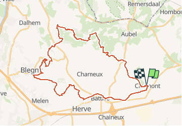
Randonnée Marche de 40 km à découvrir à Wallonie, Liège, Thimister-Clermont. Cette randonnée est proposée par benoitdemez.
Description
En empruntant de petits sentiers nous traverserons une grande partie du pays de Herve.
Par les vallées du Boland, de la Richelette et de la Berwinne. Passage sur le site de l'abbaye de Val Dieu.
Localisation
Pays :
Belgique
Région :
Wallonie
Département/Province :
Liège
Commune :
Thimister-Clermont
Localité :
Clermont
Départ:(Dec)
Départ:(UTM)
703752 ; 5615972 (31U) N.
Commentaires
Randonnées à proximité
![Randonnée Marche Thimister-Clermont - La Minerie - Photo](https://media.geolcdn.com/t/375/260/ext.jpg?maxdim=2&url=https%3A%2F%2Fstatic1.geolcdn.com%2Fsiteimages%2Fupload%2Ffiles%2F1553511878bg_sport_marche.png)
![Marche Marche](https://static1.geolcdn.com/sitytour/trail-icons/101.png)
La Minerie
Marche
Facile
(6)
Thimister-Clermont,
Wallonie,
Liège,
Belgique
![](/images/other/stat-length.png)
12,9 km | 15,7 km-effort
3h 22min
![](https://static1.geolcdn.com/siteimages/upload/files/16400158638029165_repeat_loop_refresh_sync_direction_icon.png)
Oui
![Randonnée Marche Herve - Thimister et son Marché de Noël 🎅🎄 alsacien 🥨 - Photo](https://media.geolcdn.com/t/375/260/3e67f0de-4933-4699-a966-0b37dcd8155f.jpg&format=jpg&maxdim=2)
![Marche Marche](https://static1.geolcdn.com/sitytour/trail-icons/101.png)
Thimister et son Marché de Noël 🎅🎄 alsacien 🥨
Marche
Facile
(1)
Herve,
Wallonie,
Liège,
Belgique
![](/images/other/stat-length.png)
12,7 km | 15,4 km-effort
2h 46min
![](https://static1.geolcdn.com/siteimages/upload/files/16400158638029165_repeat_loop_refresh_sync_direction_icon.png)
Oui
![Randonnée Marche Thimister-Clermont - Froidthier - Photo](https://media.geolcdn.com/t/375/260/9142f7fe-feb5-4533-8005-65992f1c4338.jpg&format=jpg&maxdim=2)
![Marche Marche](https://static1.geolcdn.com/sitytour/trail-icons/101.png)
Froidthier
Marche
Facile
(1)
Thimister-Clermont,
Wallonie,
Liège,
Belgique
![](/images/other/stat-length.png)
6,6 km | 7,9 km-effort
1h 48min
![](https://static1.geolcdn.com/siteimages/upload/files/16400158638029165_repeat_loop_refresh_sync_direction_icon.png)
Oui
![Marche Marche](https://static1.geolcdn.com/sitytour/trail-icons/101.png)
20220428 - Bois de Hess 6.7 Km
Marche
Moyen
(1)
Plombières,
Wallonie,
Liège,
Belgique
![](/images/other/stat-length.png)
6,7 km | 8,4 km-effort
3h 11min
![](https://static1.geolcdn.com/siteimages/upload/files/16400158638029165_repeat_loop_refresh_sync_direction_icon.png)
Oui
![Marche Marche](https://static1.geolcdn.com/sitytour/trail-icons/101.png)
20220327 - Fort de Battice - 6.7 Km
Marche
Moyen
(2)
Herve,
Wallonie,
Liège,
Belgique
![](/images/other/stat-length.png)
6,3 km | 8 km-effort
2h 1min
![](https://static1.geolcdn.com/siteimages/upload/files/16400158638029165_repeat_loop_refresh_sync_direction_icon.png)
Oui
![Randonnée Marche Thimister-Clermont - La Minerie - Photo](https://media.geolcdn.com/t/375/260/2cdc1fed-57d0-4e96-9f7c-8bfb9eab2451.jpg&format=jpg&maxdim=2)
![Marche Marche](https://static1.geolcdn.com/sitytour/trail-icons/101.png)
La Minerie
Marche
Facile
(2)
Thimister-Clermont,
Wallonie,
Liège,
Belgique
![](/images/other/stat-length.png)
11,1 km | 13,6 km-effort
3h 5min
![](https://static1.geolcdn.com/siteimages/upload/files/16400158638029165_repeat_loop_refresh_sync_direction_icon.png)
Oui
![Randonnée Marche Limbourg - RL-GG-11_Dolhain-Gileppe_Pepinster - Photo](https://media.geolcdn.com/t/375/260/9cf2c240-5913-4088-b4f6-6c0e1fae0233.jpg&format=jpg&maxdim=2)
![Marche Marche](https://static1.geolcdn.com/sitytour/trail-icons/101.png)
RL-GG-11_Dolhain-Gileppe_Pepinster
Marche
Très difficile
(2)
Limbourg,
Wallonie,
Liège,
Belgique
![](/images/other/stat-length.png)
20 km | 26 km-effort
5h 33min
![](https://static1.geolcdn.com/siteimages/upload/files/16400158638029165_repeat_loop_refresh_sync_direction_icon.png)
Non
![Randonnée Marche Aubel - RB-Lg-04_Aubel_via-racc - Photo](https://media.geolcdn.com/t/375/260/ext.jpg?maxdim=2&url=https%3A%2F%2Fservices.sitytrail.com%2FGeolivesWS%2FDownloadMedia.ashx%3FTrailID%3D209393%26Media%3D9ac6c0af-9a08-4948-b5d5-06a09e8ba132.jpg)
![Marche Marche](https://static1.geolcdn.com/sitytour/trail-icons/101.png)
RB-Lg-04_Aubel_via-racc
Marche
Moyen
(4)
Aubel,
Wallonie,
Liège,
Belgique
![](/images/other/stat-length.png)
17,1 km | 22 km-effort
4h 50min
![](https://static1.geolcdn.com/siteimages/upload/files/16400158638029165_repeat_loop_refresh_sync_direction_icon.png)
Oui
![Randonnée V.T.T. Aubel - 20220727 Yeyette à Gorhez - Photo](https://media.geolcdn.com/t/375/260/3e91e36a-9872-4e44-80fe-5903cdab6ed3.jpg&format=jpg&maxdim=2)
![V.T.T. V.T.T.](https://static1.geolcdn.com/sitytour/trail-icons/202.png)
20220727 Yeyette à Gorhez
V.T.T.
Moyen
(1)
Aubel,
Wallonie,
Liège,
Belgique
![](/images/other/stat-length.png)
33 km | 41 km-effort
2h 33min
![](https://static1.geolcdn.com/siteimages/upload/files/16400158638029165_repeat_loop_refresh_sync_direction_icon.png)
Oui