![](/images/other/stat-length.png)
![Randonnée V.T.C. Champeaux - Boucle Champeaux (Light) - Photo](https://media.geolcdn.com/t/1900/400/2b1bb30f-5440-479e-aa11-f32d5141f790.bmp&format=pjpeg&maxdim=2)
Boucle Champeaux (Light)
Bntg
Utilisateur
![Longueur](/images/other/stat-length.png)
![Altitude max](https://static1.geolcdn.com/siteimages/upload/files/1508320355ic_sort_altitude_max_24dp.png)
![Dénivelé positif](https://static1.geolcdn.com/siteimages/upload/files/1508320355ic_sort_den_pos_24dp.png)
![Km-Effort](/images/other/stat-length.png)
![Altitude min](https://static1.geolcdn.com/siteimages/upload/files/1508320355ic_sort_altitude_min_24dp.png)
![Dénivelé négatif](https://static1.geolcdn.com/siteimages/upload/files/1508320355ic_sort_den_neg_24dp.png)
![Boucle](https://static1.geolcdn.com/siteimages/upload/files/16400158638029165_repeat_loop_refresh_sync_direction_icon.png)
![V.T.C.](https://static1.geolcdn.com/sitytour/trail-icons/203.png)
--
Difficulté : Moyen
![Scannez ce code QR pour ouvrir la randonnée dans l'application SityTrail](https://capi.geolives.com/qq0zvz2zws4bq2lad0pu/sitytour/trails/2466372/qr.png?size=200)
Application GPS de randonnée GRATUITE
À propos
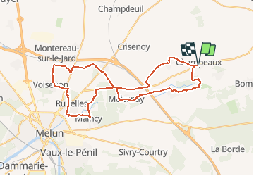
Randonnée V.T.C. de 35 km à découvrir à Île-de-France, Seine-et-Marne, Champeaux. Cette randonnée est proposée par Bntg.
Description
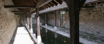
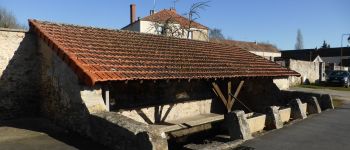
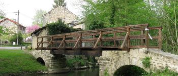
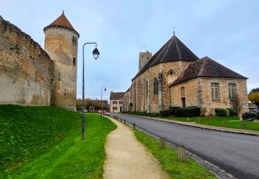
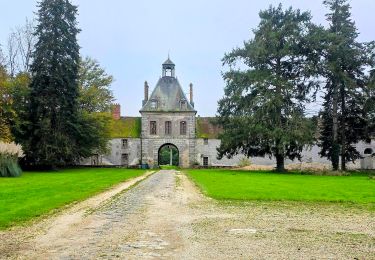
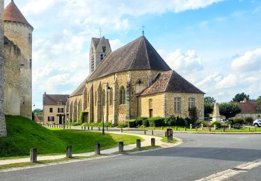
Un petit tour dans la Brie en passant par de magnifiques villages et devant des lavoirs, édifices religieux, et châteaux dont celui de Vaux-le -Vicomte.
Quelques Km sur routes moins agréables que d'autres mais difficile de faire autrement dans la région.
Pour les amateurs de VTT, choisissez la Rando: "Boucle Champeaux" normale; il y a un passage pour vous.
Localisation
Commentaires
Randonnées à proximité
![Randonnée Marche Blandy - JC 52 Eglises Médiévales de la Brie, La Collégiale de Champeaux - Photo](https://media.geolcdn.com/t/375/260/aed965fb-0abe-4a92-b759-defb35e3ca63.jpg&format=jpg&maxdim=2)
![Marche Marche](https://static1.geolcdn.com/sitytour/trail-icons/101.png)
Marche
![](/images/other/stat-length.png)
![](https://static1.geolcdn.com/siteimages/upload/files/16400158638029165_repeat_loop_refresh_sync_direction_icon.png)
![Randonnée Marche Blandy - Boucle 23 km Blandy - St Merry - Bombon - Champeaux - Photo](https://media.geolcdn.com/t/375/260/810a2001-48d6-47b8-9b9c-600abddda76e.jpg&format=jpg&maxdim=2)
![Marche Marche](https://static1.geolcdn.com/sitytour/trail-icons/101.png)
Marche
![](/images/other/stat-length.png)
![](https://static1.geolcdn.com/siteimages/upload/files/16400158638029165_repeat_loop_refresh_sync_direction_icon.png)
![Randonnée A pied Bombon - Boucle 30 km autour de Bombon - Photo](https://media.geolcdn.com/t/375/260/3c20580b-5dc5-4b7b-ad19-7338a4cd3174.jpg&format=jpg&maxdim=2)
![A pied A pied](https://static1.geolcdn.com/sitytour/trail-icons/100.png)
A pied
![](/images/other/stat-length.png)
![](https://static1.geolcdn.com/siteimages/upload/files/16400158638029165_repeat_loop_refresh_sync_direction_icon.png)
![Randonnée Marche Blandy - Boucle 21 km Blandy - Bombom - St Mery - Champeaux - Photo](https://media.geolcdn.com/t/375/260/a365a7e1-c890-4e35-bd6d-01d4e699b3cc.jpg&format=jpg&maxdim=2)
![Marche Marche](https://static1.geolcdn.com/sitytour/trail-icons/101.png)
Marche
![](/images/other/stat-length.png)
![](https://static1.geolcdn.com/siteimages/upload/files/16400158638029165_repeat_loop_refresh_sync_direction_icon.png)
![Randonnée Marche Blandy - Boucle autour de Blandy par Corinne - Photo](https://media.geolcdn.com/t/375/260/e1753442-473d-4613-9ca0-8082f000c750.jpg&format=jpg&maxdim=2)
![Marche Marche](https://static1.geolcdn.com/sitytour/trail-icons/101.png)
Marche
![](/images/other/stat-length.png)
![](https://static1.geolcdn.com/siteimages/upload/files/16400158638029165_repeat_loop_refresh_sync_direction_icon.png)
![Randonnée Marche Blandy - JC 15 - 21 km Curiosités autour de Blandy - Photo](https://media.geolcdn.com/t/375/260/ext.jpg?maxdim=2&url=https%3A%2F%2Fstatic1.geolcdn.com%2Fsiteimages%2Fupload%2Ffiles%2F1553511878bg_sport_marche.png)
![Marche Marche](https://static1.geolcdn.com/sitytour/trail-icons/101.png)
Marche
![](/images/other/stat-length.png)
![](https://static1.geolcdn.com/siteimages/upload/files/16400158638029165_repeat_loop_refresh_sync_direction_icon.png)
![Randonnée Marche Saint-Méry - Boucle autour de Saint Mery 20 km - Photo](https://media.geolcdn.com/t/375/260/8aa4e70e-d8ab-4b1b-897f-cd1520e1f018.jpg&format=jpg&maxdim=2)
![Marche Marche](https://static1.geolcdn.com/sitytour/trail-icons/101.png)
Marche
![](/images/other/stat-length.png)
![](https://static1.geolcdn.com/siteimages/upload/files/16400158638029165_repeat_loop_refresh_sync_direction_icon.png)
![Randonnée Marche Moisenay - Boucle 29 km autour de Moisenay - Photo](https://media.geolcdn.com/t/375/260/ext.jpg?maxdim=2&url=https%3A%2F%2Fstatic1.geolcdn.com%2Fsiteimages%2Fupload%2Ffiles%2F1553511878bg_sport_marche.png)
![Marche Marche](https://static1.geolcdn.com/sitytour/trail-icons/101.png)
Marche
![](/images/other/stat-length.png)
![](https://static1.geolcdn.com/siteimages/upload/files/16400158638029165_repeat_loop_refresh_sync_direction_icon.png)
![Randonnée Marche Bombon - Bombon 2023 - Photo](https://media.geolcdn.com/t/375/260/c3a1b84c-b69d-45b3-8086-587b8bb5cc10.jpg&format=jpg&maxdim=2)
![Marche Marche](https://static1.geolcdn.com/sitytour/trail-icons/101.png)
Marche
![](/images/other/stat-length.png)
![](https://static1.geolcdn.com/siteimages/upload/files/16400158638029165_repeat_loop_refresh_sync_direction_icon.png)