![](/images/other/stat-length.png)
![Randonnée A pied Beaucaire - Les Trois Croix - Photo](https://media.geolcdn.com/t/1900/400/65e98512-a0c0-42c4-a66c-63a19204ceee.jpg&format=pjpeg&maxdim=2)
Les Trois Croix
Michele.nigri
Utilisateur
![Longueur](/images/other/stat-length.png)
![Altitude max](https://static1.geolcdn.com/siteimages/upload/files/1508320355ic_sort_altitude_max_24dp.png)
![Dénivelé positif](https://static1.geolcdn.com/siteimages/upload/files/1508320355ic_sort_den_pos_24dp.png)
![Km-Effort](/images/other/stat-length.png)
![Altitude min](https://static1.geolcdn.com/siteimages/upload/files/1508320355ic_sort_altitude_min_24dp.png)
![Dénivelé négatif](https://static1.geolcdn.com/siteimages/upload/files/1508320355ic_sort_den_neg_24dp.png)
![Boucle](https://static1.geolcdn.com/siteimages/upload/files/16400158638029165_repeat_loop_refresh_sync_direction_icon.png)
![A pied](https://static1.geolcdn.com/sitytour/trail-icons/100.png)
--
Difficulté : Facile
![Scannez ce code QR pour ouvrir la randonnée dans l'application SityTrail](https://capi.geolives.com/qq0zvz2zws4bq2lad0pu/sitytour/trails/2465302/qr.png?size=200)
Application GPS de randonnée GRATUITE
À propos
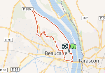
Randonnée A pied de 7,9 km à découvrir à Occitanie, Gard, Beaucaire. Cette randonnée est proposée par Michele.nigri.
Description
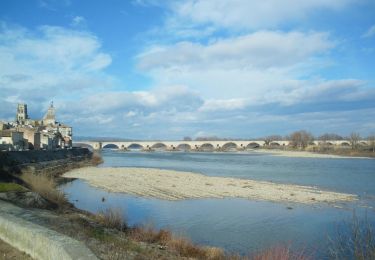
Départ Casino de Beaucaire (Point infos Randos). En suivant le balisage jaune, aller vers la Base Nautique, Pont de Beaucaire, Port de Plaisance, Cours Gambetta puis Beaucaire.
De la Mairie de Beaucaire, aller plein nord dans la rue de l'Hôtel de Ville, tourner à gauche puis à droite sur le Parvis de l'Eglise Notre Dame des Pommiers, continuer par la droite puis tourner à gauche à la Rue de la République et à droite sur le place du Château jusqu'au pied du château.
Prendre en face, ouest le bd Mal Joffre, puis à droite la rue de la Gaieté, et la rue de la Montagne.
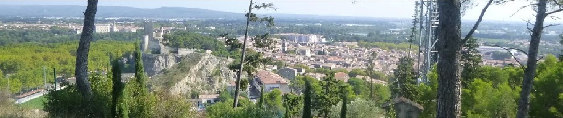
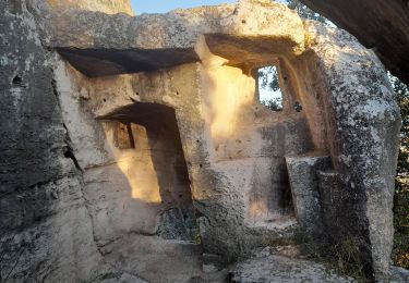
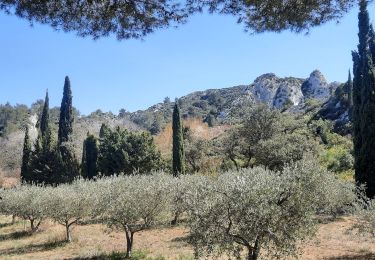
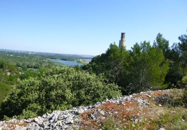
Après la barrière, laisser le balisage jaune pour monter par le chemin de Croix. Au sommet magnifique vue sur le château de Beaucaire, de Tarascon, Beaucaire, le Rhône.... Continuer sur le sentier qui file à l'ouest. Vous y trouverez un petit monument : il s'agit des vestiges de l'ancien échafaud. Continuer en reprenant sur la gauche la piste balisée jaune.
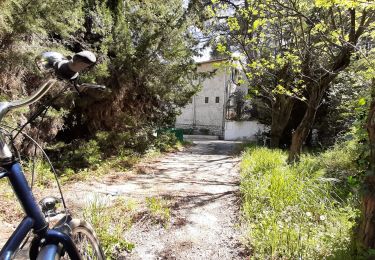
Continuer en suivant le balisage jusqu'à Le Sizen, continuer, traverser les maisons puis la route ((Gaudon-Cabiscol) et continuer dans les rues (balisage rouge et blanc jaune) pour arriver à Chemin de Verdelle. Prendre la voie Verte par la droite et continuer jusqu'à trouver une faille dans le rocher, sur la droite, ou vous traverserez la route (Prudence !) et rejoindre les bords du Rhône qui vous ramèneront au Casino Municipal de Beaucaire.
Localisation
Commentaires
Randonnées à proximité
![Randonnée Marche Comps - Abbaye de St-Roman - Photo](https://media.geolcdn.com/t/375/260/ext.jpg?maxdim=2&url=https%3A%2F%2Fstatic1.geolcdn.com%2Fsiteimages%2Fupload%2Ffiles%2F1553511878bg_sport_marche.png)
![Marche Marche](https://static1.geolcdn.com/sitytour/trail-icons/101.png)
Marche
![](/images/other/stat-length.png)
![](https://static1.geolcdn.com/siteimages/upload/files/16400158638029165_repeat_loop_refresh_sync_direction_icon.png)
![Randonnée Marche Beaucaire - Abbaye de St Roman - Photo](https://media.geolcdn.com/t/375/260/8c877511-f40c-47d0-bd81-191c52b671f7.jpg&format=jpg&maxdim=2)
![Marche Marche](https://static1.geolcdn.com/sitytour/trail-icons/101.png)
Marche
![](/images/other/stat-length.png)
![](https://static1.geolcdn.com/siteimages/upload/files/16400158638029165_repeat_loop_refresh_sync_direction_icon.png)
![Randonnée Marche Tarascon - Chapelle Saint Gabriel - Photo](https://media.geolcdn.com/t/375/260/1c3c9e5f-4b3f-45fb-8d88-46fd497cc285.jpg&format=jpg&maxdim=2)
![Marche Marche](https://static1.geolcdn.com/sitytour/trail-icons/101.png)
Marche
![](/images/other/stat-length.png)
![](https://static1.geolcdn.com/siteimages/upload/files/16400158638029165_repeat_loop_refresh_sync_direction_icon.png)
![Randonnée Marche Beaucaire - Saint Roman - Beaucaire - Photo](https://media.geolcdn.com/t/375/260/ext.jpg?maxdim=2&url=https%3A%2F%2Fstatic1.geolcdn.com%2Fsiteimages%2Fupload%2Ffiles%2F1553511878bg_sport_marche.png)
![Marche Marche](https://static1.geolcdn.com/sitytour/trail-icons/101.png)
Marche
![](/images/other/stat-length.png)
![](https://static1.geolcdn.com/siteimages/upload/files/16400158638029165_repeat_loop_refresh_sync_direction_icon.png)
![Randonnée Marche Tarascon - CR_Domitia_BA_23_Tarascon_St-Remy-Provence_20220404 - Photo](https://media.geolcdn.com/t/375/260/0c688a23-1608-47e8-9d00-9c82cd40f42d.jpg&format=jpg&maxdim=2)
![Marche Marche](https://static1.geolcdn.com/sitytour/trail-icons/101.png)
Marche
![](/images/other/stat-length.png)
![](https://static1.geolcdn.com/siteimages/upload/files/16400158638029165_repeat_loop_refresh_sync_direction_icon.png)
![Randonnée V.T.C. Comps - Voie verte depuis barrage de Vallabrègues Intersport Marguillier Saint Félix et fin au château de Beaucaire - Photo](https://media.geolcdn.com/t/375/260/b8af9095-2e18-4f11-ab3b-e3441a4a64e5.jpg&format=jpg&maxdim=2)
![V.T.C. V.T.C.](https://static1.geolcdn.com/sitytour/trail-icons/203.png)
V.T.C.
![](/images/other/stat-length.png)
![](https://static1.geolcdn.com/siteimages/upload/files/16400158638029165_repeat_loop_refresh_sync_direction_icon.png)
![Randonnée Marche Beaucaire - Beaucaire/ St Roman - Photo](https://media.geolcdn.com/t/375/260/645788a5-fdf8-4c75-8e8f-1cd4c1ad6e8e.jpg&format=jpg&maxdim=2)
![Marche Marche](https://static1.geolcdn.com/sitytour/trail-icons/101.png)
Marche
![](/images/other/stat-length.png)
![](https://static1.geolcdn.com/siteimages/upload/files/16400158638029165_repeat_loop_refresh_sync_direction_icon.png)
![Randonnée A pied Beaucaire - La Bouteille - Photo](https://media.geolcdn.com/t/375/260/d5c2e4f5-8ab7-4d0e-b4b1-72d9a30aca11.png&format=jpg&maxdim=2)
![A pied A pied](https://static1.geolcdn.com/sitytour/trail-icons/100.png)
![Randonnée Vélo Tarascon - Via Rhôna de Tarascon à bourg-saint-andéol - Photo](https://media.geolcdn.com/t/375/260/ext.jpg?maxdim=2&url=https%3A%2F%2Fservices.sitytrail.com%2FGeolivesWS%2FDownloadMedia.ashx%3FTrailID%3D450856%26Media%3D5f7b4689-bef8-459c-9c8e-28bda3fe4e7b.jpg)
![Vélo Vélo](https://static1.geolcdn.com/sitytour/trail-icons/200.png)
Vélo
![](/images/other/stat-length.png)
![](https://static1.geolcdn.com/siteimages/upload/files/16400158638029165_repeat_loop_refresh_sync_direction_icon.png)