![](/images/other/stat-length.png)
![Randonnée Marche Aubiat - Aubiat_Morge_Moulins - Photo](https://media.geolcdn.com/t/1900/400/51e9d754-8203-4ee7-89d1-2f4fd8e10da5.jpg&format=pjpeg&maxdim=2)
Aubiat_Morge_Moulins
jagarnier
Utilisateur GUIDE
![Longueur](/images/other/stat-length.png)
Longueur
7,1 km
![Altitude max](https://static1.geolcdn.com/siteimages/upload/files/1508320355ic_sort_altitude_max_24dp.png)
Altitude max
368 m
![Dénivelé positif](https://static1.geolcdn.com/siteimages/upload/files/1508320355ic_sort_den_pos_24dp.png)
Dénivelé positif
69 m
![Km-Effort](/images/other/stat-length.png)
Km-Effort
8 km
![Altitude min](https://static1.geolcdn.com/siteimages/upload/files/1508320355ic_sort_altitude_min_24dp.png)
Altitude min
332 m
![Dénivelé négatif](https://static1.geolcdn.com/siteimages/upload/files/1508320355ic_sort_den_neg_24dp.png)
Dénivelé négatif
68 m
![Boucle](https://static1.geolcdn.com/siteimages/upload/files/16400158638029165_repeat_loop_refresh_sync_direction_icon.png)
Boucle
Oui
Date de création :
2020-07-06 05:07:03.737
Dernière modification :
2024-05-31 07:00:49.123
![Marche](https://static1.geolcdn.com/sitytour/trail-icons/101.png)
2h15
Difficulté : Facile
![Scannez ce code QR pour ouvrir la randonnée dans l'application SityTrail](https://capi.geolives.com/qq0zvz2zws4bq2lad0pu/sitytour/trails/2463853/qr.png?size=200)
Application GPS de randonnée GRATUITE
À propos
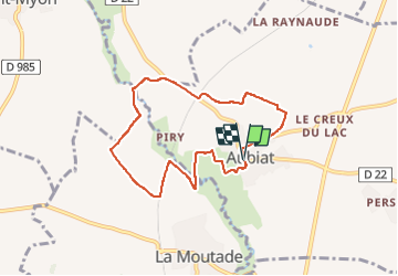
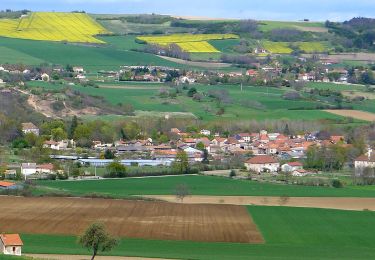
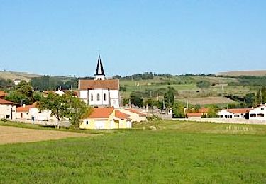
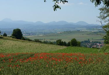
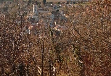
Randonnée Marche de 7,1 km à découvrir à Auvergne-Rhône-Alpes, Puy-de-Dôme, Aubiat. Cette randonnée est proposée par jagarnier.
Description
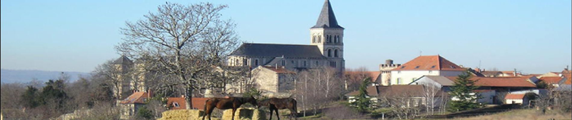
La Morge prend sa source dans les Combrailles. C’est un affluent de l’Allier en rive gauche avec laquelle elle conflue peu après Maringues. La rivière est connue pour ses moulins, ses tanneries et ses vieux ponts.
Localisation
Pays :
France
Région :
Auvergne-Rhône-Alpes
Département/Province :
Puy-de-Dôme
Commune :
Aubiat
Localité :
Unknown
Départ:(Dec)
Départ:(UTM)
512962 ; 5091464 (31T) N.
Commentaires
Randonnées à proximité
![Randonnée Marche Artonne - D'Artonne à Chaptuzat - Photo](https://media.geolcdn.com/t/375/260/ext.jpg?maxdim=2&url=https%3A%2F%2Fservices.sitytrail.com%2FGeolivesWS%2FDownloadMedia.ashx%3FTrailID%3D118756%26Media%3D12953_3.jpg)
![Marche Marche](https://static1.geolcdn.com/sitytour/trail-icons/101.png)
D'Artonne à Chaptuzat
Marche
Difficile
(1)
Artonne,
Auvergne-Rhône-Alpes,
Puy-de-Dôme,
France
![](/images/other/stat-length.png)
23 km | 30 km-effort
5h 49min
![](https://static1.geolcdn.com/siteimages/upload/files/16400158638029165_repeat_loop_refresh_sync_direction_icon.png)
Oui
![Randonnée Marche Artonne - La croix des Rameaux - Photo](https://media.geolcdn.com/t/375/260/ext.jpg?maxdim=2&url=https%3A%2F%2Fservices.sitytrail.com%2FGeolivesWS%2FDownloadMedia.ashx%3FTrailID%3D103205%26Media%3D5072_2.jpg)
![Marche Marche](https://static1.geolcdn.com/sitytour/trail-icons/101.png)
La croix des Rameaux
Marche
Moyen
(2)
Artonne,
Auvergne-Rhône-Alpes,
Puy-de-Dôme,
France
![](/images/other/stat-length.png)
11,2 km | 14,3 km-effort
2h 45min
![](https://static1.geolcdn.com/siteimages/upload/files/16400158638029165_repeat_loop_refresh_sync_direction_icon.png)
Oui
![Randonnée A pied Artonne - La Croix des Rameaux et le Puy St Jean - Photo](https://media.geolcdn.com/t/375/260/9db434b7-077f-4e6c-8975-0828554befef.jpeg&format=jpg&maxdim=2)
![A pied A pied](https://static1.geolcdn.com/sitytour/trail-icons/100.png)
La Croix des Rameaux et le Puy St Jean
A pied
Facile
Artonne,
Auvergne-Rhône-Alpes,
Puy-de-Dôme,
France
![](/images/other/stat-length.png)
10,5 km | 13,6 km-effort
3h 5min
![](https://static1.geolcdn.com/siteimages/upload/files/16400158638029165_repeat_loop_refresh_sync_direction_icon.png)
Oui
![Randonnée Marche Aubiat - Aubiat - Artonne - Photo](https://media.geolcdn.com/t/375/260/5fa1274e-0bad-4aee-891d-9bf8ee46dd55.jpg&format=jpg&maxdim=2)
![Marche Marche](https://static1.geolcdn.com/sitytour/trail-icons/101.png)
Aubiat - Artonne
Marche
Moyen
Aubiat,
Auvergne-Rhône-Alpes,
Puy-de-Dôme,
France
![](/images/other/stat-length.png)
14,5 km | 16,9 km-effort
3h 45min
![](https://static1.geolcdn.com/siteimages/upload/files/16400158638029165_repeat_loop_refresh_sync_direction_icon.png)
Oui
![Randonnée Marche Saint-Myon - St_Myon_Morge_Puy_Loule - Photo](https://media.geolcdn.com/t/375/260/c0a7d910-5736-46ae-a46c-a507799fe316.jpg&format=jpg&maxdim=2)
![Marche Marche](https://static1.geolcdn.com/sitytour/trail-icons/101.png)
St_Myon_Morge_Puy_Loule
Marche
Facile
Saint-Myon,
Auvergne-Rhône-Alpes,
Puy-de-Dôme,
France
![](/images/other/stat-length.png)
9,3 km | 11,1 km-effort
2h 45min
![](https://static1.geolcdn.com/siteimages/upload/files/16400158638029165_repeat_loop_refresh_sync_direction_icon.png)
Oui
![Randonnée Marche Beauregard-Vendon - Chaptes_Puy_Loule - Photo](https://media.geolcdn.com/t/375/260/1a8bd21e-a533-44a7-8047-91aa9b10a554.jpg&format=jpg&maxdim=2)
![Marche Marche](https://static1.geolcdn.com/sitytour/trail-icons/101.png)
Chaptes_Puy_Loule
Marche
Facile
Beauregard-Vendon,
Auvergne-Rhône-Alpes,
Puy-de-Dôme,
France
![](/images/other/stat-length.png)
6,5 km | 8,3 km-effort
2h 0min
![](https://static1.geolcdn.com/siteimages/upload/files/16400158638029165_repeat_loop_refresh_sync_direction_icon.png)
Oui
![Randonnée Marche Artonne - Artonne_Croix_Rameaux - Photo](https://media.geolcdn.com/t/375/260/9530a105-4442-48c9-8361-4ca3f6ca7133.jpg&format=jpg&maxdim=2)
![Marche Marche](https://static1.geolcdn.com/sitytour/trail-icons/101.png)
Artonne_Croix_Rameaux
Marche
Facile
Artonne,
Auvergne-Rhône-Alpes,
Puy-de-Dôme,
France
![](/images/other/stat-length.png)
10,4 km | 13,4 km-effort
3h 0min
![](https://static1.geolcdn.com/siteimages/upload/files/16400158638029165_repeat_loop_refresh_sync_direction_icon.png)
Oui
![Randonnée Marche Aubiat - La Morge et ses Moulins - Photo](https://media.geolcdn.com/t/375/260/ext.jpg?maxdim=2&url=https%3A%2F%2Fstatic1.geolcdn.com%2Fsiteimages%2Fupload%2Ffiles%2F1553511878bg_sport_marche.png)
![Marche Marche](https://static1.geolcdn.com/sitytour/trail-icons/101.png)
La Morge et ses Moulins
Marche
Très facile
(1)
Aubiat,
Auvergne-Rhône-Alpes,
Puy-de-Dôme,
France
![](/images/other/stat-length.png)
7,2 km | 8,1 km-effort
1h 48min
![](https://static1.geolcdn.com/siteimages/upload/files/16400158638029165_repeat_loop_refresh_sync_direction_icon.png)
Oui
![Randonnée Marche Artonne - Cartonné. Glenat - Photo](https://media.geolcdn.com/t/375/260/5876cb65-a99b-42fe-941c-42063a3daa5b.jpg&format=jpg&maxdim=2)
![Marche Marche](https://static1.geolcdn.com/sitytour/trail-icons/101.png)
Cartonné. Glenat
Marche
Facile
Artonne,
Auvergne-Rhône-Alpes,
Puy-de-Dôme,
France
![](/images/other/stat-length.png)
10,9 km | 14 km-effort
2h 53min
![](https://static1.geolcdn.com/siteimages/upload/files/16400158638029165_repeat_loop_refresh_sync_direction_icon.png)
Oui