![](/images/other/stat-length.png)
![Randonnée Marche Venansault - sentier du Charme - Photo](https://media.geolcdn.com/t/1900/400/ext.pjpeg?maxdim=2&url=https%3A%2F%2Fstatic1.geolcdn.com%2Fsiteimages%2Fupload%2Ffiles%2F1553511878bg_sport_marche.png)
sentier du Charme
Gregory Herlaud
Utilisateur
![Longueur](/images/other/stat-length.png)
Longueur
12,9 km
![Altitude max](https://static1.geolcdn.com/siteimages/upload/files/1508320355ic_sort_altitude_max_24dp.png)
Altitude max
75 m
![Dénivelé positif](https://static1.geolcdn.com/siteimages/upload/files/1508320355ic_sort_den_pos_24dp.png)
Dénivelé positif
93 m
![Km-Effort](/images/other/stat-length.png)
Km-Effort
14,1 km
![Altitude min](https://static1.geolcdn.com/siteimages/upload/files/1508320355ic_sort_altitude_min_24dp.png)
Altitude min
45 m
![Dénivelé négatif](https://static1.geolcdn.com/siteimages/upload/files/1508320355ic_sort_den_neg_24dp.png)
Dénivelé négatif
94 m
![Boucle](https://static1.geolcdn.com/siteimages/upload/files/16400158638029165_repeat_loop_refresh_sync_direction_icon.png)
Boucle
Oui
Date de création :
2020-07-03 16:08:13.876
Dernière modification :
2020-07-03 16:22:28.775
![Marche](https://static1.geolcdn.com/sitytour/trail-icons/101.png)
3h08
Difficulté : Difficile
![Scannez ce code QR pour ouvrir la randonnée dans l'application SityTrail](https://capi.geolives.com/qq0zvz2zws4bq2lad0pu/sitytour/trails/2460389/qr.png?size=200)
Application GPS de randonnée GRATUITE
À propos
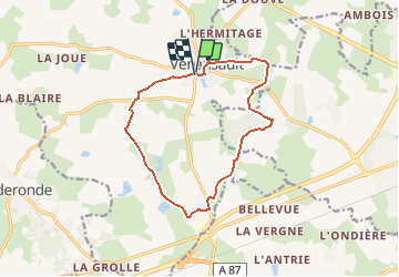
Randonnée Marche de 12,9 km à découvrir à Pays de la Loire, Vendée, Venansault. Cette randonnée est proposée par Gregory Herlaud.
Description
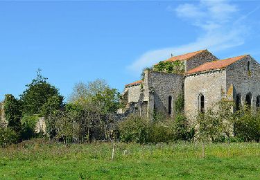
Sur ce parcours au balisage jaune, au gré d'un petit détour, les plus curieux pourront aller découvrir l'Abbaye des Fontenelles. en reprenant le circuit vous longerez le bois des Fontenelles.
Localisation
Pays :
France
Région :
Pays de la Loire
Département/Province :
Vendée
Commune :
Venansault
Localité :
Unknown
Départ:(Dec)
Départ:(UTM)
613582 ; 5171067 (30T) N.
Commentaires
Randonnées à proximité
![Randonnée Marche Venansault - VENANSAULT - Photo](https://media.geolcdn.com/t/375/260/af11b64d-ba48-4b3c-92d4-2bed5d3ca1d2.jpg&format=jpg&maxdim=2)
![Marche Marche](https://static1.geolcdn.com/sitytour/trail-icons/101.png)
VENANSAULT
Marche
Très facile
Venansault,
Pays de la Loire,
Vendée,
France
![](/images/other/stat-length.png)
14,2 km | 15,5 km-effort
3h 13min
![](https://static1.geolcdn.com/siteimages/upload/files/16400158638029165_repeat_loop_refresh_sync_direction_icon.png)
Oui
![Randonnée Marche La Roche-sur-Yon - La Roche sur Yon, coté Ouest - Photo](https://media.geolcdn.com/t/375/260/ext.jpg?maxdim=2&url=https%3A%2F%2Fservices.sitytrail.com%2FGeolivesWS%2FDownloadMedia.ashx%3FTrailID%3D173118%26Media%3D14668_2.jpg)
![Marche Marche](https://static1.geolcdn.com/sitytour/trail-icons/101.png)
La Roche sur Yon, coté Ouest
Marche
Difficile
La Roche-sur-Yon,
Pays de la Loire,
Vendée,
France
![](/images/other/stat-length.png)
23 km | 25 km-effort
6h 0min
![](https://static1.geolcdn.com/siteimages/upload/files/16400158638029165_repeat_loop_refresh_sync_direction_icon.png)
Oui
![Randonnée Marche Landeronde - LANDERONDE ( UKRAINE) - Photo](https://media.geolcdn.com/t/375/260/ext.jpg?maxdim=2&url=https%3A%2F%2Fstatic1.geolcdn.com%2Fsiteimages%2Fupload%2Ffiles%2F1553511878bg_sport_marche.png)
![Marche Marche](https://static1.geolcdn.com/sitytour/trail-icons/101.png)
LANDERONDE ( UKRAINE)
Marche
Facile
Landeronde,
Pays de la Loire,
Vendée,
France
![](/images/other/stat-length.png)
23 km | 25 km-effort
4h 1min
![](https://static1.geolcdn.com/siteimages/upload/files/16400158638029165_repeat_loop_refresh_sync_direction_icon.png)
Oui
![Randonnée V.T.T. Venansault - la Boursière - Photo](https://media.geolcdn.com/t/375/260/ext.jpg?maxdim=2&url=https%3A%2F%2Fstatic1.geolcdn.com%2Fsiteimages%2Fupload%2Ffiles%2F1524743154velo.jpg)
![V.T.T. V.T.T.](https://static1.geolcdn.com/sitytour/trail-icons/202.png)
la Boursière
V.T.T.
Facile
Venansault,
Pays de la Loire,
Vendée,
France
![](/images/other/stat-length.png)
9,6 km | 10,7 km-effort
58min
![](https://static1.geolcdn.com/siteimages/upload/files/16400158638029165_repeat_loop_refresh_sync_direction_icon.png)
Non
![Randonnée V.T.C. La Roche-sur-Yon - Brancaire - Photo](https://media.geolcdn.com/t/375/260/ext.jpg?maxdim=2&url=https%3A%2F%2Fstatic1.geolcdn.com%2Fsiteimages%2Fupload%2Ffiles%2F1524743154velo.jpg)
![V.T.C. V.T.C.](https://static1.geolcdn.com/sitytour/trail-icons/203.png)
Brancaire
V.T.C.
Moyen
La Roche-sur-Yon,
Pays de la Loire,
Vendée,
France
![](/images/other/stat-length.png)
18,4 km | 20 km-effort
1h 17min
![](https://static1.geolcdn.com/siteimages/upload/files/16400158638029165_repeat_loop_refresh_sync_direction_icon.png)
Oui
![Randonnée Trail Aizenay - Forêt Aizenay - Photo](https://media.geolcdn.com/t/375/260/ext.jpg?maxdim=2&url=https%3A%2F%2Fstatic1.geolcdn.com%2Fsiteimages%2Fupload%2Ffiles%2F1524743154running.jpg)
![Trail Trail](https://static1.geolcdn.com/sitytour/trail-icons/104.png)
Forêt Aizenay
Trail
Facile
Aizenay,
Pays de la Loire,
Vendée,
France
![](/images/other/stat-length.png)
9,2 km | 10 km-effort
1h 0min
![](https://static1.geolcdn.com/siteimages/upload/files/16400158638029165_repeat_loop_refresh_sync_direction_icon.png)
Oui
![Randonnée V.T.T. Aizenay - Forêt Aizenay - Photo](https://media.geolcdn.com/t/375/260/ext.jpg?maxdim=2&url=https%3A%2F%2Fstatic1.geolcdn.com%2Fsiteimages%2Fupload%2Ffiles%2F1524743154velo.jpg)
![V.T.T. V.T.T.](https://static1.geolcdn.com/sitytour/trail-icons/202.png)
Forêt Aizenay
V.T.T.
Facile
Aizenay,
Pays de la Loire,
Vendée,
France
![](/images/other/stat-length.png)
8,5 km | 9,2 km-effort
50min
![](https://static1.geolcdn.com/siteimages/upload/files/16400158638029165_repeat_loop_refresh_sync_direction_icon.png)
Oui
![Randonnée Marche La Roche-sur-Yon - val d'Amboise à la roulier en circuit - Photo](https://media.geolcdn.com/t/375/260/ext.jpg?maxdim=2&url=https%3A%2F%2Fstatic1.geolcdn.com%2Fsiteimages%2Fupload%2Ffiles%2F1553511878bg_sport_marche.png)
![Marche Marche](https://static1.geolcdn.com/sitytour/trail-icons/101.png)
val d'Amboise à la roulier en circuit
Marche
Moyen
La Roche-sur-Yon,
Pays de la Loire,
Vendée,
France
![](/images/other/stat-length.png)
6 km | 6,6 km-effort
1h 20min
![](https://static1.geolcdn.com/siteimages/upload/files/16400158638029165_repeat_loop_refresh_sync_direction_icon.png)
Oui
![Randonnée V.T.T. La Roche-sur-Yon - chemins saint André d'Ornay - Photo](https://media.geolcdn.com/t/375/260/ext.jpg?maxdim=2&url=https%3A%2F%2Fstatic1.geolcdn.com%2Fsiteimages%2Fupload%2Ffiles%2F1524743154velo.jpg)
![V.T.T. V.T.T.](https://static1.geolcdn.com/sitytour/trail-icons/202.png)
chemins saint André d'Ornay
V.T.T.
Facile
La Roche-sur-Yon,
Pays de la Loire,
Vendée,
France
![](/images/other/stat-length.png)
8,8 km | 10 km-effort
3h 10min
![](https://static1.geolcdn.com/siteimages/upload/files/16400158638029165_repeat_loop_refresh_sync_direction_icon.png)
Non