![](/images/other/stat-length.png)
20200207-Barneville Journee
doudet
Utilisateur
![Longueur](/images/other/stat-length.png)
Longueur
22 km
![Altitude max](https://static1.geolcdn.com/siteimages/upload/files/1508320355ic_sort_altitude_max_24dp.png)
Altitude max
145 m
![Dénivelé positif](https://static1.geolcdn.com/siteimages/upload/files/1508320355ic_sort_den_pos_24dp.png)
Dénivelé positif
469 m
![Km-Effort](/images/other/stat-length.png)
Km-Effort
29 km
![Altitude min](https://static1.geolcdn.com/siteimages/upload/files/1508320355ic_sort_altitude_min_24dp.png)
Altitude min
0 m
![Dénivelé négatif](https://static1.geolcdn.com/siteimages/upload/files/1508320355ic_sort_den_neg_24dp.png)
Dénivelé négatif
468 m
![Boucle](https://static1.geolcdn.com/siteimages/upload/files/16400158638029165_repeat_loop_refresh_sync_direction_icon.png)
Boucle
Oui
Date de création :
2020-07-02 07:21:01.309
Dernière modification :
2020-07-03 06:38:33.057
![Marche](https://static1.geolcdn.com/sitytour/trail-icons/101.png)
6h35
Difficulté : Difficile
![Scannez ce code QR pour ouvrir la randonnée dans l'application SityTrail](https://capi.geolives.com/qq0zvz2zws4bq2lad0pu/sitytour/trails/2459099/qr.png?size=200)
Application GPS de randonnée GRATUITE
À propos
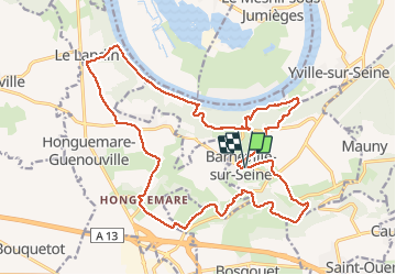
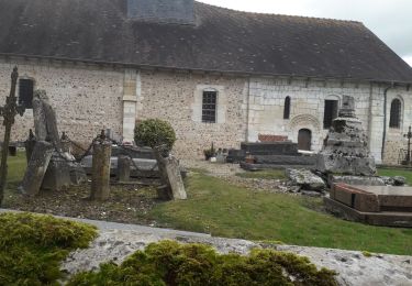
Randonnée Marche de 22 km à découvrir à Normandie, Eure, Barneville-sur-Seine. Cette randonnée est proposée par doudet.
Description
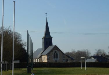
Boucle A-R à partir de l'Eglise de Barneville
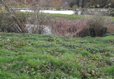
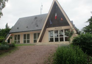
Localisation
Pays :
France
Région :
Normandie
Département/Province :
Eure
Commune :
Barneville-sur-Seine
Localité :
Unknown
Départ:(Dec)
Départ:(UTM)
343883 ; 5471879 (31U) N.
Commentaires
Randonnées à proximité
![Randonnée Marche Saint-Ouen-de-Thouberville - Saint-Ouen de Thouberville- Le Mesnil et la Pierre TTournante - Photo](https://media.geolcdn.com/t/375/260/f2450d67-38f3-46a5-aba6-c5e54414bed0.jpg&format=jpg&maxdim=2)
![Marche Marche](https://static1.geolcdn.com/sitytour/trail-icons/101.png)
Saint-Ouen de Thouberville- Le Mesnil et la Pierre TTournante
Marche
Moyen
(1)
Saint-Ouen-de-Thouberville,
Normandie,
Eure,
France
![](/images/other/stat-length.png)
12,5 km | 15,3 km-effort
3h 35min
![](https://static1.geolcdn.com/siteimages/upload/files/16400158638029165_repeat_loop_refresh_sync_direction_icon.png)
Oui
![Randonnée Cheval Barneville-sur-Seine - Circuit des Côtes - Barneville sur Seine - Photo](https://media.geolcdn.com/t/375/260/ext.jpg?maxdim=2&url=https%3A%2F%2Fservices.sitytrail.com%2FGeolivesWS%2FDownloadMedia.ashx%3FTrailID%3D111652%26Media%3D7891_1.jpg)
![Cheval Cheval](https://static1.geolcdn.com/sitytour/trail-icons/300.png)
Circuit des Côtes - Barneville sur Seine
Cheval
Facile
(1)
Barneville-sur-Seine,
Normandie,
Eure,
France
![](/images/other/stat-length.png)
5,9 km | 8 km-effort
1h 0min
![](https://static1.geolcdn.com/siteimages/upload/files/16400158638029165_repeat_loop_refresh_sync_direction_icon.png)
Oui
![Marche Marche](https://static1.geolcdn.com/sitytour/trail-icons/101.png)
20230302-Barneville sur Seine
Marche
Difficile
Barneville-sur-Seine,
Normandie,
Eure,
France
![](/images/other/stat-length.png)
13,1 km | 16,6 km-effort
3h 31min
![](https://static1.geolcdn.com/siteimages/upload/files/16400158638029165_repeat_loop_refresh_sync_direction_icon.png)
Oui
![Randonnée Marche Barneville-sur-Seine - Les Grottes de l'Aubrière - Photo](https://media.geolcdn.com/t/375/260/ext.jpg?maxdim=2&url=https%3A%2F%2Fstatic1.geolcdn.com%2Fsiteimages%2Fupload%2Ffiles%2F1553511878bg_sport_marche.png)
![Marche Marche](https://static1.geolcdn.com/sitytour/trail-icons/101.png)
Les Grottes de l'Aubrière
Marche
Moyen
(1)
Barneville-sur-Seine,
Normandie,
Eure,
France
![](/images/other/stat-length.png)
23 km | 29 km-effort
6h 23min
![](https://static1.geolcdn.com/siteimages/upload/files/16400158638029165_repeat_loop_refresh_sync_direction_icon.png)
Oui
![Randonnée Marche Saint-Ouen-de-Thouberville - Saint-Ouen de Thouberville. Vers la pierre Tourmante et le Mesnil version 12-11-21 - Photo](https://media.geolcdn.com/t/375/260/b86f4944-9744-4f8e-8b37-981417450b71.jpg&format=jpg&maxdim=2)
![Marche Marche](https://static1.geolcdn.com/sitytour/trail-icons/101.png)
Saint-Ouen de Thouberville. Vers la pierre Tourmante et le Mesnil version 12...
Marche
Difficile
Saint-Ouen-de-Thouberville,
Normandie,
Eure,
France
![](/images/other/stat-length.png)
12,8 km | 15,6 km-effort
3h 55min
![](https://static1.geolcdn.com/siteimages/upload/files/16400158638029165_repeat_loop_refresh_sync_direction_icon.png)
Oui
![Marche Marche](https://static1.geolcdn.com/sitytour/trail-icons/101.png)
20210617-Mauny
Marche
Moyen
Mauny,
Normandie,
Seine-Maritime,
France
![](/images/other/stat-length.png)
13,4 km | 17,1 km-effort
3h 56min
![](https://static1.geolcdn.com/siteimages/upload/files/16400158638029165_repeat_loop_refresh_sync_direction_icon.png)
Oui
![Randonnée Marche Saint-Ouen-de-Thouberville - Saint-ouen de Thouberville vers Caumont et la Trinité - Photo](https://media.geolcdn.com/t/375/260/65995c4c-1068-4aea-b32b-c3e75089db70.jpg&format=jpg&maxdim=2)
![Marche Marche](https://static1.geolcdn.com/sitytour/trail-icons/101.png)
Saint-ouen de Thouberville vers Caumont et la Trinité
Marche
Moyen
Saint-Ouen-de-Thouberville,
Normandie,
Eure,
France
![](/images/other/stat-length.png)
9,4 km | 11,2 km-effort
2h 44min
![](https://static1.geolcdn.com/siteimages/upload/files/16400158638029165_repeat_loop_refresh_sync_direction_icon.png)
Oui
![Randonnée Marche Bourg-Achard - La belle Epine - Photo](https://media.geolcdn.com/t/375/260/b0ee3f85-baa3-4ee2-b67f-18d8213a59cf.jpg&format=jpg&maxdim=2)
![Marche Marche](https://static1.geolcdn.com/sitytour/trail-icons/101.png)
La belle Epine
Marche
Facile
(2)
Bourg-Achard,
Normandie,
Eure,
France
![](/images/other/stat-length.png)
10,1 km | 11 km-effort
3h 15min
![](https://static1.geolcdn.com/siteimages/upload/files/16400158638029165_repeat_loop_refresh_sync_direction_icon.png)
Oui
![Randonnée Marche Mauny - Mauny (46) - Photo](https://media.geolcdn.com/t/375/260/ext.jpg?maxdim=2&url=https%3A%2F%2Fstatic1.geolcdn.com%2Fsiteimages%2Fupload%2Ffiles%2F1553511878bg_sport_marche.png)
![Marche Marche](https://static1.geolcdn.com/sitytour/trail-icons/101.png)
Mauny (46)
Marche
Facile
(2)
Mauny,
Normandie,
Seine-Maritime,
France
![](/images/other/stat-length.png)
8,8 km | 10,3 km-effort
2h 18min
![](https://static1.geolcdn.com/siteimages/upload/files/16400158638029165_repeat_loop_refresh_sync_direction_icon.png)
Oui