![](/images/other/stat-length.png)
![Randonnée Marche Plougoumelen - N.D. de Béquerel - Plougoumelen - Anse de Lann Vihan - Le Bono - Photo](https://media.geolcdn.com/t/1900/400/ext.pjpeg?maxdim=2&url=https%3A%2F%2Fstatic1.geolcdn.com%2Fsiteimages%2Fupload%2Ffiles%2F1553511878bg_sport_marche.png)
N.D. de Béquerel - Plougoumelen - Anse de Lann Vihan - Le Bono
PAM2235
Utilisateur
![Longueur](/images/other/stat-length.png)
Longueur
10,6 km
![Altitude max](https://static1.geolcdn.com/siteimages/upload/files/1508320355ic_sort_altitude_max_24dp.png)
Altitude max
31 m
![Dénivelé positif](https://static1.geolcdn.com/siteimages/upload/files/1508320355ic_sort_den_pos_24dp.png)
Dénivelé positif
122 m
![Km-Effort](/images/other/stat-length.png)
Km-Effort
12,2 km
![Altitude min](https://static1.geolcdn.com/siteimages/upload/files/1508320355ic_sort_altitude_min_24dp.png)
Altitude min
-1 m
![Dénivelé négatif](https://static1.geolcdn.com/siteimages/upload/files/1508320355ic_sort_den_neg_24dp.png)
Dénivelé négatif
121 m
![Boucle](https://static1.geolcdn.com/siteimages/upload/files/16400158638029165_repeat_loop_refresh_sync_direction_icon.png)
Boucle
Oui
Date de création :
2020-06-30 16:59:54.013
Dernière modification :
2021-10-01 17:21:34.285
![Marche](https://static1.geolcdn.com/sitytour/trail-icons/101.png)
2h35
Difficulté : Moyen
![Scannez ce code QR pour ouvrir la randonnée dans l'application SityTrail](https://capi.geolives.com/qq0zvz2zws4bq2lad0pu/sitytour/trails/2456654/qr.png?size=200)
Application GPS de randonnée GRATUITE
À propos
Randonnée Marche de 10,6 km à découvrir à Bretagne, Morbihan, Plougoumelen. Cette randonnée est proposée par PAM2235.
Description
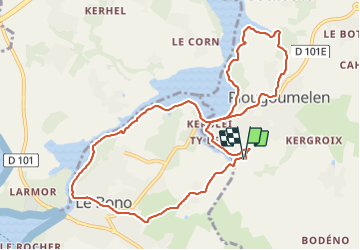
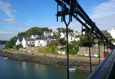
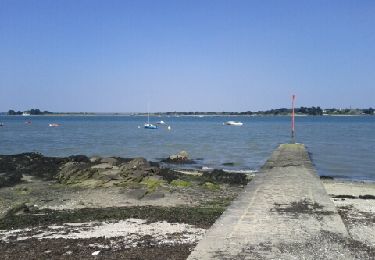
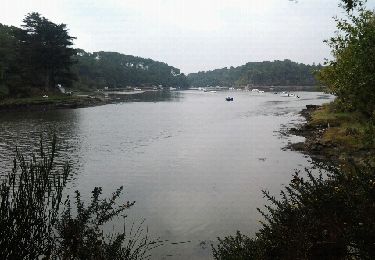
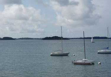
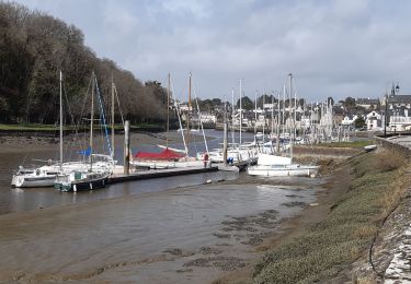
Circuit de 10,5 km au départ du parking de la chapelle Notre-Dame de Béquerel. Ce circuit permet de suivre la rive gauche de la rivière du Bono de l'anse de Lann Vihan au port du Bono et de découvrir les bourgs de Plougoumelen et du Bono.
Localisation
Pays :
France
Région :
Bretagne
Département/Province :
Morbihan
Commune :
Plougoumelen
Localité :
Unknown
Départ:(Dec)
Départ:(UTM)
505740 ; 5276866 (30T) N.
Commentaires
Randonnées à proximité
![Randonnée Marche Le Bono - Du Bono à la Chapelle de Saint-Avoye - Photo](https://media.geolcdn.com/t/375/260/ext.jpg?maxdim=2&url=https%3A%2F%2Fservices.sitytrail.com%2FGeolivesWS%2FDownloadMedia.ashx%3FTrailID%3D455675%26Media%3Dfix__20150807180035.jpg)
![Marche Marche](https://static1.geolcdn.com/sitytour/trail-icons/101.png)
Du Bono à la Chapelle de Saint-Avoye
Marche
Facile
(1)
Le Bono,
Bretagne,
Morbihan,
France
![](/images/other/stat-length.png)
8 km | 9,3 km-effort
2h 47min
![](https://static1.geolcdn.com/siteimages/upload/files/16400158638029165_repeat_loop_refresh_sync_direction_icon.png)
Oui
![Randonnée Marche Baden - Ile aux Moines - Photo](https://media.geolcdn.com/t/375/260/ext.jpg?maxdim=2&url=https%3A%2F%2Fservices.sitytrail.com%2FGeolivesWS%2FDownloadMedia.ashx%3FTrailID%3D204495%26Media%3Dfix__20130708163141.jpg)
![Marche Marche](https://static1.geolcdn.com/sitytour/trail-icons/101.png)
Ile aux Moines
Marche
Facile
(1)
Baden,
Bretagne,
Morbihan,
France
![](/images/other/stat-length.png)
19,8 km | 22 km-effort
4h 53min
![](https://static1.geolcdn.com/siteimages/upload/files/16400158638029165_repeat_loop_refresh_sync_direction_icon.png)
Non
![Randonnée Marche Pluneret - st Avoye - Photo](https://media.geolcdn.com/t/375/260/ext.jpg?maxdim=2&url=https%3A%2F%2Fservices.sitytrail.com%2FGeolivesWS%2FDownloadMedia.ashx%3FTrailID%3D159588%26Media%3D20121024110349.jpeg)
![Marche Marche](https://static1.geolcdn.com/sitytour/trail-icons/101.png)
![Randonnée Marche Ploeren - Ploeren - Photo](https://media.geolcdn.com/t/375/260/ext.jpg?maxdim=2&url=https%3A%2F%2Fstatic1.geolcdn.com%2Fsiteimages%2Fupload%2Ffiles%2F1553511878bg_sport_marche.png)
![Marche Marche](https://static1.geolcdn.com/sitytour/trail-icons/101.png)
Ploeren
Marche
Très facile
(1)
Ploeren,
Bretagne,
Morbihan,
France
![](/images/other/stat-length.png)
5,4 km | 6,1 km-effort
1h 27min
![](https://static1.geolcdn.com/siteimages/upload/files/16400158638029165_repeat_loop_refresh_sync_direction_icon.png)
Oui
![Randonnée Marche Baden - PR_56_Baden_AB_05_Circuit4a_Anse-Du-Moustran_20240908 - Photo](https://media.geolcdn.com/t/375/260/a2cc3589-c64a-4b8b-8252-b3acfcad70d8.jpg&format=jpg&maxdim=2)
![Marche Marche](https://static1.geolcdn.com/sitytour/trail-icons/101.png)
PR_56_Baden_AB_05_Circuit4a_Anse-Du-Moustran_20240908
Marche
Facile
Baden,
Bretagne,
Morbihan,
France
![](/images/other/stat-length.png)
8,1 km | 9,3 km-effort
1h 43min
![](https://static1.geolcdn.com/siteimages/upload/files/16400158638029165_repeat_loop_refresh_sync_direction_icon.png)
Oui
![Randonnée Marche Pluneret - PR_56_Pluneret_EA_06_Circuit1b_Tro-Ar-Vourch_20240227 - Photo](https://media.geolcdn.com/t/375/260/5d6bdb50-6a7c-4d72-8e80-1296b3e69841.jpg&format=jpg&maxdim=2)
![Marche Marche](https://static1.geolcdn.com/sitytour/trail-icons/101.png)
PR_56_Pluneret_EA_06_Circuit1b_Tro-Ar-Vourch_20240227
Marche
Très facile
Pluneret,
Bretagne,
Morbihan,
France
![](/images/other/stat-length.png)
7,3 km | 8,2 km-effort
1h 51min
![](https://static1.geolcdn.com/siteimages/upload/files/16400158638029165_repeat_loop_refresh_sync_direction_icon.png)
Oui
![Randonnée Marche Plougoumelen - PR_56_Plougoumelen_CA_03_Circuit4a_Du-Boterff_20231011 - Photo](https://media.geolcdn.com/t/375/260/d3c418c5-7ec8-4dd5-81ed-a4f492fa39d3.jpg&format=jpg&maxdim=2)
![Marche Marche](https://static1.geolcdn.com/sitytour/trail-icons/101.png)
PR_56_Plougoumelen_CA_03_Circuit4a_Du-Boterff_20231011
Marche
Facile
Plougoumelen,
Bretagne,
Morbihan,
France
![](/images/other/stat-length.png)
10 km | 11,8 km-effort
2h 40min
![](https://static1.geolcdn.com/siteimages/upload/files/16400158638029165_repeat_loop_refresh_sync_direction_icon.png)
Oui
![Randonnée Marche Baden - PR_56_Baden_CA_03_Circuit4a_Bois-Bourgerel_20230826 - Photo](https://media.geolcdn.com/t/375/260/de3b635d-62db-43c4-97a4-c6a0e3f84db8.jpg&format=jpg&maxdim=2)
![Marche Marche](https://static1.geolcdn.com/sitytour/trail-icons/101.png)
PR_56_Baden_CA_03_Circuit4a_Bois-Bourgerel_20230826
Marche
Facile
Baden,
Bretagne,
Morbihan,
France
![](/images/other/stat-length.png)
10,3 km | 11,8 km-effort
2h 1min
![](https://static1.geolcdn.com/siteimages/upload/files/16400158638029165_repeat_loop_refresh_sync_direction_icon.png)
Oui
![Randonnée Marche Auray - port saint goustan,port bono - Photo](https://media.geolcdn.com/t/375/260/12116764-6d8c-4e87-8742-90bc6f2c0827.jpg&format=jpg&maxdim=2)
![Marche Marche](https://static1.geolcdn.com/sitytour/trail-icons/101.png)
port saint goustan,port bono
Marche
Facile
Auray,
Bretagne,
Morbihan,
France
![](/images/other/stat-length.png)
14,3 km | 16,5 km-effort
3h 17min
![](https://static1.geolcdn.com/siteimages/upload/files/16400158638029165_repeat_loop_refresh_sync_direction_icon.png)
Oui