![](/images/other/stat-length.png)
Sceautres
pb07
Utilisateur
![Longueur](/images/other/stat-length.png)
Longueur
17,8 km
![Altitude max](https://static1.geolcdn.com/siteimages/upload/files/1508320355ic_sort_altitude_max_24dp.png)
Altitude max
553 m
![Dénivelé positif](https://static1.geolcdn.com/siteimages/upload/files/1508320355ic_sort_den_pos_24dp.png)
Dénivelé positif
534 m
![Km-Effort](/images/other/stat-length.png)
Km-Effort
25 km
![Altitude min](https://static1.geolcdn.com/siteimages/upload/files/1508320355ic_sort_altitude_min_24dp.png)
Altitude min
206 m
![Dénivelé négatif](https://static1.geolcdn.com/siteimages/upload/files/1508320355ic_sort_den_neg_24dp.png)
Dénivelé négatif
534 m
![Boucle](https://static1.geolcdn.com/siteimages/upload/files/16400158638029165_repeat_loop_refresh_sync_direction_icon.png)
Boucle
Oui
Date de création :
2014-12-10 00:00:00.0
Dernière modification :
2014-12-10 00:00:00.0
![Marche](https://static1.geolcdn.com/sitytour/trail-icons/101.png)
5h13
Difficulté : Facile
![Scannez ce code QR pour ouvrir la randonnée dans l'application SityTrail](https://capi.geolives.com/qq0zvz2zws4bq2lad0pu/sitytour/trails/245162/qr.png?size=200)
Application GPS de randonnée GRATUITE
À propos
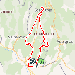
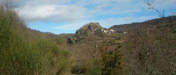
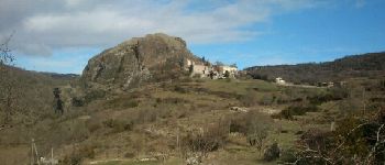
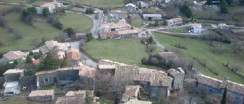
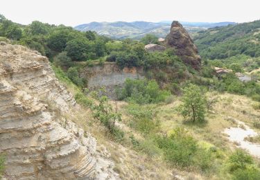
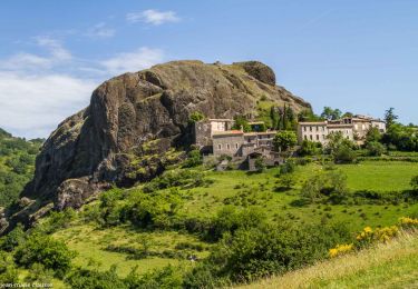
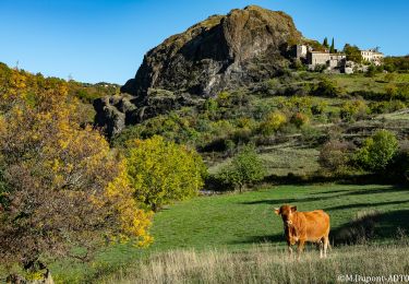
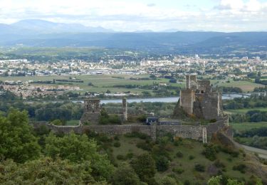
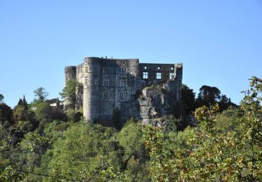
Randonnée Marche de 17,8 km à découvrir à Auvergne-Rhône-Alpes, Ardèche, Alba-la-Romaine. Cette randonnée est proposée par pb07.
Description
Départ du parking de la cave coopérative en bordure de la RN102.
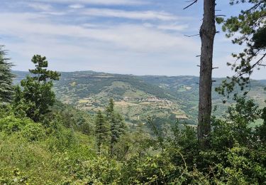
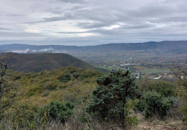
Départ pas très agréable le long de la route puis bons chemins bien balisés tout le long.
Localisation
Pays :
France
Région :
Auvergne-Rhône-Alpes
Département/Province :
Ardèche
Commune :
Alba-la-Romaine
Localité :
Unknown
Départ:(Dec)
Départ:(UTM)
627115 ; 4936064 (31T) N.
Commentaires
Randonnées à proximité
![Randonnée Marche Saint-Pons - St-Pons](https://media.geolcdn.com/t/375/260/49091a69-1e24-42da-a42c-558f715b7cf2.jpg&format=jpg&maxdim=2)
![Marche Marche](https://static1.geolcdn.com/sitytour/trail-icons/101.png)
St-Pons" Roche-Cherie" 11km.
Marche
Difficile
(1)
Saint-Pons,
Auvergne-Rhône-Alpes,
Ardèche,
France
![](/images/other/stat-length.png)
10,5 km | 15,5 km-effort
3h 31min
![](https://static1.geolcdn.com/siteimages/upload/files/16400158638029165_repeat_loop_refresh_sync_direction_icon.png)
Oui
![Randonnée Marche Alba-la-Romaine - Alba côté Coiron 7km - Photo](https://media.geolcdn.com/t/375/260/a3628db1-82f7-410a-bbb5-05b986f870eb.jpg&format=jpg&maxdim=2)
![Marche Marche](https://static1.geolcdn.com/sitytour/trail-icons/101.png)
Alba côté Coiron 7km
Marche
Facile
(1)
Alba-la-Romaine,
Auvergne-Rhône-Alpes,
Ardèche,
France
![](/images/other/stat-length.png)
7,1 km | 9,5 km-effort
2h 30min
![](https://static1.geolcdn.com/siteimages/upload/files/16400158638029165_repeat_loop_refresh_sync_direction_icon.png)
Oui
![Randonnée Marche Alba-la-Romaine - Sceautres-La carrière 15km. - Photo](https://media.geolcdn.com/t/375/260/bc490022-33bf-4369-aab3-d65614438b0b.jpg&format=jpg&maxdim=2)
![Marche Marche](https://static1.geolcdn.com/sitytour/trail-icons/101.png)
Sceautres-La carrière 15km.
Marche
Très difficile
(1)
Alba-la-Romaine,
Auvergne-Rhône-Alpes,
Ardèche,
France
![](/images/other/stat-length.png)
14,7 km | 22 km-effort
4h 57min
![](https://static1.geolcdn.com/siteimages/upload/files/16400158638029165_repeat_loop_refresh_sync_direction_icon.png)
Oui
![Randonnée Marche Aubignas - Aubignas Chenavari 17km - Photo](https://media.geolcdn.com/t/375/260/68a339cd-0c18-4833-bd47-74ba80f6463a.jpeg&format=jpg&maxdim=2)
![Marche Marche](https://static1.geolcdn.com/sitytour/trail-icons/101.png)
Aubignas Chenavari 17km
Marche
Difficile
Aubignas,
Auvergne-Rhône-Alpes,
Ardèche,
France
![](/images/other/stat-length.png)
16,5 km | 25 km-effort
5h 20min
![](https://static1.geolcdn.com/siteimages/upload/files/16400158638029165_repeat_loop_refresh_sync_direction_icon.png)
Oui
![Randonnée V.T.T. Aubignas - Aubignas tour coiron all mountain - Photo](https://media.geolcdn.com/t/375/260/ext.jpg?maxdim=2&url=https%3A%2F%2Fstatic1.geolcdn.com%2Fsiteimages%2Fupload%2Ffiles%2F1524743154velo.jpg)
![V.T.T. V.T.T.](https://static1.geolcdn.com/sitytour/trail-icons/202.png)
Aubignas tour coiron all mountain
V.T.T.
Difficile
(2)
Aubignas,
Auvergne-Rhône-Alpes,
Ardèche,
France
![](/images/other/stat-length.png)
20 km | 30 km-effort
1h 54min
![](https://static1.geolcdn.com/siteimages/upload/files/16400158638029165_repeat_loop_refresh_sync_direction_icon.png)
Non
![Randonnée V.T.T. Sceautres - COIRON boucle sympa - Photo](https://media.geolcdn.com/t/375/260/ext.jpg?maxdim=2&url=https%3A%2F%2Fstatic1.geolcdn.com%2Fsiteimages%2Fupload%2Ffiles%2F1524743154velo.jpg)
![V.T.T. V.T.T.](https://static1.geolcdn.com/sitytour/trail-icons/202.png)
COIRON boucle sympa
V.T.T.
Moyen
(2)
Sceautres,
Auvergne-Rhône-Alpes,
Ardèche,
France
![](/images/other/stat-length.png)
7,4 km | 10,4 km-effort
1h 10min
![](https://static1.geolcdn.com/siteimages/upload/files/16400158638029165_repeat_loop_refresh_sync_direction_icon.png)
Oui
![Randonnée Marche Alba-la-Romaine - Alba-la-Romaine](https://media.geolcdn.com/t/375/260/89593791-b9d1-4134-81c3-e3d68616a883.jpg&format=jpg&maxdim=2)
![Marche Marche](https://static1.geolcdn.com/sitytour/trail-icons/101.png)
Alba-la-Romaine "Col de L'épine le Mont juliau" 13km.
Marche
Difficile
Alba-la-Romaine,
Auvergne-Rhône-Alpes,
Ardèche,
France
![](/images/other/stat-length.png)
12,4 km | 18 km-effort
4h 4min
![](https://static1.geolcdn.com/siteimages/upload/files/16400158638029165_repeat_loop_refresh_sync_direction_icon.png)
Oui
![Randonnée Marche Aubignas - Aubignas 14km - Photo](https://media.geolcdn.com/t/375/260/ad84676e-e951-47f4-b7a2-e7e68ce8281c.jpg&format=jpg&maxdim=2)
![Marche Marche](https://static1.geolcdn.com/sitytour/trail-icons/101.png)
Aubignas 14km
Marche
Difficile
Aubignas,
Auvergne-Rhône-Alpes,
Ardèche,
France
![](/images/other/stat-length.png)
14,4 km | 23 km-effort
5h 7min
![](https://static1.geolcdn.com/siteimages/upload/files/16400158638029165_repeat_loop_refresh_sync_direction_icon.png)
Oui
![Randonnée Marche Alba-la-Romaine - Alba-La-Romaine Le Montagut 13km. - Photo](https://media.geolcdn.com/t/375/260/692959aa-610a-46a9-b85b-5fdc5eb23fb9.jpg&format=jpg&maxdim=2)
![Marche Marche](https://static1.geolcdn.com/sitytour/trail-icons/101.png)
Alba-La-Romaine Le Montagut 13km.
Marche
Difficile
Alba-la-Romaine,
Auvergne-Rhône-Alpes,
Ardèche,
France
![](/images/other/stat-length.png)
12,7 km | 17,7 km-effort
4h 0min
![](https://static1.geolcdn.com/siteimages/upload/files/16400158638029165_repeat_loop_refresh_sync_direction_icon.png)
Oui