![](/images/other/stat-length.png)
![Randonnée Marche Saint-Laurent-le-Minier - SAINT-LAURENT-LE-MINIER – OISELETTE - 11.7Km - 04h30 - Dénivelé 650 m - Photo](https://media.geolcdn.com/t/1900/400/ext.pjpeg?maxdim=2&url=https%3A%2F%2Fstatic1.geolcdn.com%2Fsiteimages%2Fupload%2Ffiles%2F1553511878bg_sport_marche.png)
SAINT-LAURENT-LE-MINIER – OISELETTE - 11.7Km - 04h30 - Dénivelé 650 m
dansmabulle
Utilisateur
![Longueur](/images/other/stat-length.png)
Longueur
11,7 km
![Altitude max](https://static1.geolcdn.com/siteimages/upload/files/1508320355ic_sort_altitude_max_24dp.png)
Altitude max
714 m
![Dénivelé positif](https://static1.geolcdn.com/siteimages/upload/files/1508320355ic_sort_den_pos_24dp.png)
Dénivelé positif
642 m
![Km-Effort](/images/other/stat-length.png)
Km-Effort
20 km
![Altitude min](https://static1.geolcdn.com/siteimages/upload/files/1508320355ic_sort_altitude_min_24dp.png)
Altitude min
179 m
![Dénivelé négatif](https://static1.geolcdn.com/siteimages/upload/files/1508320355ic_sort_den_neg_24dp.png)
Dénivelé négatif
636 m
![Boucle](https://static1.geolcdn.com/siteimages/upload/files/16400158638029165_repeat_loop_refresh_sync_direction_icon.png)
Boucle
Oui
Date de création :
2014-12-10 00:00:00.0
Dernière modification :
2014-12-10 00:00:00.0
![Marche](https://static1.geolcdn.com/sitytour/trail-icons/101.png)
4h07
Difficulté : Moyen
![Scannez ce code QR pour ouvrir la randonnée dans l'application SityTrail](https://capi.geolives.com/qq0zvz2zws4bq2lad0pu/sitytour/trails/245148/qr.png?size=200)
Application GPS de randonnée GRATUITE
À propos
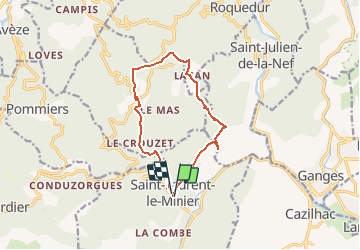
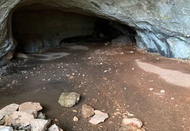
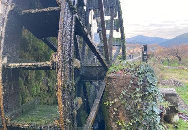
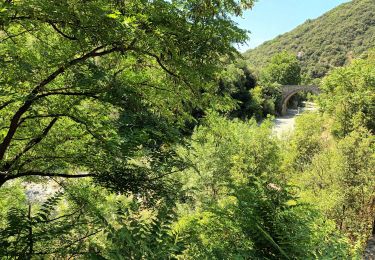
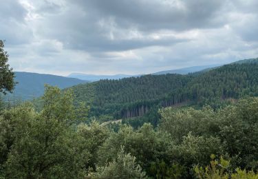
Randonnée Marche de 11,7 km à découvrir à Occitanie, Gard, Saint-Laurent-le-Minier. Cette randonnée est proposée par dansmabulle.
Description
Départ randonnée : Village de St-Laurent-le-Minier (Gard 30)
Depuis St-Laurent-le-Minier, vous montez jusqu'au sommet de l'Oiselette en passant par Lacam.
Vous revenez au point de départ en passant par St-Bresson.
Bonne randonnée
Localisation
Pays :
France
Région :
Occitanie
Département/Province :
Gard
Commune :
Saint-Laurent-le-Minier
Localité :
Unknown
Départ:(Dec)
Départ:(UTM)
552712 ; 4864308 (31T) N.
Commentaires
Randonnées à proximité
![Randonnée Marche Ganges - les Mines de Ganges - Photo](https://media.geolcdn.com/t/375/260/ext.jpg?maxdim=2&url=https%3A%2F%2Fservices.sitytrail.com%2FGeolivesWS%2FDownloadMedia.ashx%3FTrailID%3D835756%26Media%3D20170926145921.jpg)
![Marche Marche](https://static1.geolcdn.com/sitytour/trail-icons/101.png)
les Mines de Ganges
Marche
Moyen
(4)
Ganges,
Occitanie,
Hérault,
France
![](/images/other/stat-length.png)
12 km | 17,5 km-effort
5h 30min
![](https://static1.geolcdn.com/siteimages/upload/files/16400158638029165_repeat_loop_refresh_sync_direction_icon.png)
Oui
![Randonnée Marche Saint-Laurent-le-Minier - pic et grotte d Anneau au depart de St Laurent le Minier - Photo](https://media.geolcdn.com/t/375/260/f8302bfe-8e81-4700-a65e-4420a9b2464f.jpg&format=jpg&maxdim=2)
![Marche Marche](https://static1.geolcdn.com/sitytour/trail-icons/101.png)
pic et grotte d Anneau au depart de St Laurent le Minier
Marche
Difficile
Saint-Laurent-le-Minier,
Occitanie,
Gard,
France
![](/images/other/stat-length.png)
16,4 km | 27 km-effort
7h 38min
![](https://static1.geolcdn.com/siteimages/upload/files/16400158638029165_repeat_loop_refresh_sync_direction_icon.png)
Oui
![Randonnée Marche Saint-Laurent-le-Minier - Saint-Laurent-du-Minier - grotte d'Anjeau - tour du pic d'Anjeau - cascade de la Vis - Photo](https://media.geolcdn.com/t/375/260/ext.jpg?maxdim=2&url=https%3A%2F%2Fstatic1.geolcdn.com%2Fsiteimages%2Fupload%2Ffiles%2F1553511878bg_sport_marche.png)
![Marche Marche](https://static1.geolcdn.com/sitytour/trail-icons/101.png)
Saint-Laurent-du-Minier - grotte d'Anjeau - tour du pic d'Anjeau - cascade de...
Marche
Moyen
(2)
Saint-Laurent-le-Minier,
Occitanie,
Gard,
France
![](/images/other/stat-length.png)
13,5 km | 23 km-effort
4h 52min
![](https://static1.geolcdn.com/siteimages/upload/files/16400158638029165_repeat_loop_refresh_sync_direction_icon.png)
Oui
![Randonnée Marche Ganges - Ganges Mont Méjean Patus - Photo](https://media.geolcdn.com/t/375/260/d13dbb51-1efc-45d9-b2a4-80c894df3817.jpg&format=jpg&maxdim=2)
![Marche Marche](https://static1.geolcdn.com/sitytour/trail-icons/101.png)
Ganges Mont Méjean Patus
Marche
Difficile
Ganges,
Occitanie,
Hérault,
France
![](/images/other/stat-length.png)
18,1 km | 28 km-effort
6h 16min
![](https://static1.geolcdn.com/siteimages/upload/files/16400158638029165_repeat_loop_refresh_sync_direction_icon.png)
Oui
![Randonnée Marche Ganges - Ganges - Photo](https://media.geolcdn.com/t/375/260/4575900d-b3d8-4c13-902c-aa02010ad0fe.jpg&format=jpg&maxdim=2)
![Marche Marche](https://static1.geolcdn.com/sitytour/trail-icons/101.png)
![Randonnée Marche Ganges - Ganges bois de Montmale Laroque - Photo](https://media.geolcdn.com/t/375/260/bd719afb-95dd-4c59-b658-066c5b6f640e.jpg&format=jpg&maxdim=2)
![Marche Marche](https://static1.geolcdn.com/sitytour/trail-icons/101.png)
Ganges bois de Montmale Laroque
Marche
Très difficile
Ganges,
Occitanie,
Hérault,
France
![](/images/other/stat-length.png)
16,1 km | 21 km-effort
5h 6min
![](https://static1.geolcdn.com/siteimages/upload/files/16400158638029165_repeat_loop_refresh_sync_direction_icon.png)
Oui
![Randonnée Marche Ganges - De Ganges à Laroque par le bois de Montmal - Photo](https://media.geolcdn.com/t/375/260/bc75e769-e703-48b5-8e7d-3d36e985717b.jpg&format=jpg&maxdim=2)
![Marche Marche](https://static1.geolcdn.com/sitytour/trail-icons/101.png)
De Ganges à Laroque par le bois de Montmal
Marche
Moyen
Ganges,
Occitanie,
Hérault,
France
![](/images/other/stat-length.png)
16,2 km | 21 km-effort
4h 22min
![](https://static1.geolcdn.com/siteimages/upload/files/16400158638029165_repeat_loop_refresh_sync_direction_icon.png)
Oui
![Randonnée Marche Ganges - Ranc de Banes-Ganges-13-06-22 - Photo](https://media.geolcdn.com/t/375/260/f7c9d32f-3b57-45dd-8e16-6949fe33b659.jpg&format=jpg&maxdim=2)
![Marche Marche](https://static1.geolcdn.com/sitytour/trail-icons/101.png)
Ranc de Banes-Ganges-13-06-22
Marche
Moyen
Ganges,
Occitanie,
Hérault,
France
![](/images/other/stat-length.png)
10,3 km | 17,8 km-effort
2h 54min
![](https://static1.geolcdn.com/siteimages/upload/files/16400158638029165_repeat_loop_refresh_sync_direction_icon.png)
Oui
![Randonnée Marche Saint-Bresson - Saint Bresson - Photo](https://media.geolcdn.com/t/375/260/15d7e237-e2dc-49a4-a22d-b2a753ce536e.jpg&format=jpg&maxdim=2)
![Marche Marche](https://static1.geolcdn.com/sitytour/trail-icons/101.png)
Saint Bresson
Marche
Moyen
Saint-Bresson,
Occitanie,
Gard,
France
![](/images/other/stat-length.png)
14,9 km | 23 km-effort
4h 53min
![](https://static1.geolcdn.com/siteimages/upload/files/16400158638029165_repeat_loop_refresh_sync_direction_icon.png)
Oui