![](/images/other/stat-length.png)
![Randonnée Marche Seneffe - Moulin brulé/Pont origine var1 - Photo](https://media.geolcdn.com/t/1900/400/ext.pjpeg?maxdim=2&url=https%3A%2F%2Fstatic1.geolcdn.com%2Fsiteimages%2Fupload%2Ffiles%2F1553511878bg_sport_marche.png)
Moulin brulé/Pont origine var1
calofrancis
Utilisateur
![Longueur](/images/other/stat-length.png)
Longueur
6,3 km
![Altitude max](https://static1.geolcdn.com/siteimages/upload/files/1508320355ic_sort_altitude_max_24dp.png)
Altitude max
165 m
![Dénivelé positif](https://static1.geolcdn.com/siteimages/upload/files/1508320355ic_sort_den_pos_24dp.png)
Dénivelé positif
79 m
![Km-Effort](/images/other/stat-length.png)
Km-Effort
7,3 km
![Altitude min](https://static1.geolcdn.com/siteimages/upload/files/1508320355ic_sort_altitude_min_24dp.png)
Altitude min
114 m
![Dénivelé négatif](https://static1.geolcdn.com/siteimages/upload/files/1508320355ic_sort_den_neg_24dp.png)
Dénivelé négatif
79 m
![Boucle](https://static1.geolcdn.com/siteimages/upload/files/16400158638029165_repeat_loop_refresh_sync_direction_icon.png)
Boucle
Oui
Date de création :
2018-07-07 13:33:56.721
Dernière modification :
2018-07-07 13:33:56.721
![Marche](https://static1.geolcdn.com/sitytour/trail-icons/101.png)
1h36
Difficulté : Facile
![Scannez ce code QR pour ouvrir la randonnée dans l'application SityTrail](https://capi.geolives.com/qq0zvz2zws4bq2lad0pu/sitytour/trails/245079/qr.png?size=200)
Application GPS de randonnée GRATUITE
À propos
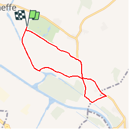
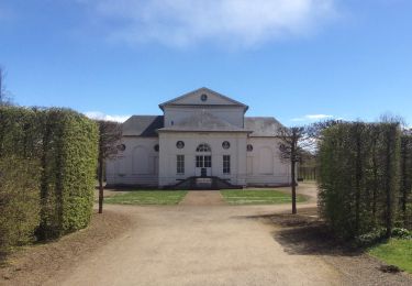
Randonnée Marche de 6,3 km à découvrir à Wallonie, Hainaut, Seneffe. Cette randonnée est proposée par calofrancis.
Description
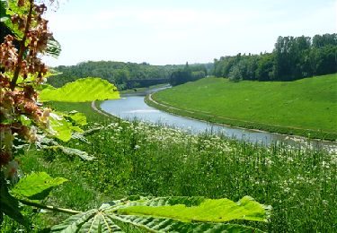
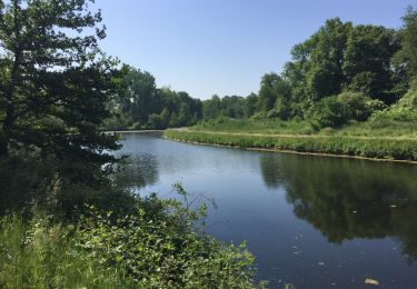
Balade à partir du parking du chäteau de Seneffe, itinéraire par chemin en dur conseillé à la mauvaise saison (sentiers abîmés,boueux).
___www.marcheursdumardi.be___
Localisation
Pays :
Belgique
Région :
Wallonie
Département/Province :
Hainaut
Commune :
Seneffe
Localité :
Seneffe
Départ:(Dec)
Départ:(UTM)
589729 ; 5597780 (31U) N.
Commentaires
Randonnées à proximité
![Randonnée Marche Seneffe - De Arquennes à Monstreux par les vallées de la Thines et de la Samme - Photo](https://media.geolcdn.com/t/375/260/ext.jpg?maxdim=2&url=https%3A%2F%2Fservices.sitytrail.com%2FGeolivesWS%2FDownloadMedia.ashx%3FTrailID%3D127787%26Media%3D79b12576-f9f5-4657-a448-2793aa9c7eb2.JPG)
![Marche Marche](https://static1.geolcdn.com/sitytour/trail-icons/101.png)
De Arquennes à Monstreux par les vallées de la Thines et de la Samme
Marche
Facile
(6)
Seneffe,
Wallonie,
Hainaut,
Belgique
![](/images/other/stat-length.png)
13,7 km | 15,4 km-effort
3h 30min
![](https://static1.geolcdn.com/siteimages/upload/files/16400158638029165_repeat_loop_refresh_sync_direction_icon.png)
Oui
![Randonnée Marche Chapelle-lez-Herlaimont - RL-GG-07_Godarville_Piéton - Photo](https://media.geolcdn.com/t/375/260/98f383e1-513d-40e1-89f6-7cac4611f0b0.jpg&format=jpg&maxdim=2)
![Marche Marche](https://static1.geolcdn.com/sitytour/trail-icons/101.png)
RL-GG-07_Godarville_Piéton
Marche
Très difficile
(4)
Chapelle-lez-Herlaimont,
Wallonie,
Hainaut,
Belgique
![](/images/other/stat-length.png)
18,8 km | 22 km-effort
4h 50min
![](https://static1.geolcdn.com/siteimages/upload/files/16400158638029165_repeat_loop_refresh_sync_direction_icon.png)
Non
![Marche Marche](https://static1.geolcdn.com/sitytour/trail-icons/101.png)
BE-Pont-à-Celles - Autour du ruisseau de Rosseignies
Marche
Facile
(2)
Pont-à-Celles,
Wallonie,
Hainaut,
Belgique
![](/images/other/stat-length.png)
7,6 km | 8,5 km-effort
1h 49min
![](https://static1.geolcdn.com/siteimages/upload/files/16400158638029165_repeat_loop_refresh_sync_direction_icon.png)
Oui
![Randonnée Marche Seneffe - RB-Ha-05 - Feluy - Via allongement - Photo](https://media.geolcdn.com/t/375/260/ext.jpg?maxdim=2&url=https%3A%2F%2Fservices.sitytrail.com%2FGeolivesWS%2FDownloadMedia.ashx%3FTrailID%3D217842%26Media%3D989f0d00-0244-4058-a77e-e5e5f489d7be.jpg)
![Marche Marche](https://static1.geolcdn.com/sitytour/trail-icons/101.png)
RB-Ha-05 - Feluy - Via allongement
Marche
Très difficile
(4)
Seneffe,
Wallonie,
Hainaut,
Belgique
![](/images/other/stat-length.png)
23 km | 26 km-effort
5h 58min
![](https://static1.geolcdn.com/siteimages/upload/files/16400158638029165_repeat_loop_refresh_sync_direction_icon.png)
Oui
![Randonnée Marche Seneffe - RB-Ha-05 - Feluy - Photo](https://media.geolcdn.com/t/375/260/ext.jpg?maxdim=2&url=https%3A%2F%2Fservices.sitytrail.com%2FGeolivesWS%2FDownloadMedia.ashx%3FTrailID%3D179598%26Media%3D989f0d00-0244-4058-a77e-e5e5f489d7be.jpg)
![Marche Marche](https://static1.geolcdn.com/sitytour/trail-icons/101.png)
RB-Ha-05 - Feluy
Marche
Très difficile
(3)
Seneffe,
Wallonie,
Hainaut,
Belgique
![](/images/other/stat-length.png)
22 km | 25 km-effort
5h 39min
![](https://static1.geolcdn.com/siteimages/upload/files/16400158638029165_repeat_loop_refresh_sync_direction_icon.png)
Oui
![Randonnée Marche Seneffe - Balade à Seneffe - Photo](https://media.geolcdn.com/t/375/260/ext.jpg?maxdim=2&url=https%3A%2F%2Fservices.sitytrail.com%2FGeolivesWS%2FDownloadMedia.ashx%3FTrailID%3D130913%26Media%3Daf2f3e93-dc12-469c-a2a0-cc8e44dbe239.JPG)
![Marche Marche](https://static1.geolcdn.com/sitytour/trail-icons/101.png)
Balade à Seneffe
Marche
Facile
(3)
Seneffe,
Wallonie,
Hainaut,
Belgique
![](/images/other/stat-length.png)
11,4 km | 12,9 km-effort
3h 0min
![](https://static1.geolcdn.com/siteimages/upload/files/16400158638029165_repeat_loop_refresh_sync_direction_icon.png)
Oui
![Marche Marche](https://static1.geolcdn.com/sitytour/trail-icons/101.png)
BE-Seneffe - Château de Seneffe - l'Ancien canal
Marche
Moyen
(1)
Seneffe,
Wallonie,
Hainaut,
Belgique
![](/images/other/stat-length.png)
6,6 km | 7,7 km-effort
1h 41min
![](https://static1.geolcdn.com/siteimages/upload/files/16400158638029165_repeat_loop_refresh_sync_direction_icon.png)
Oui
![Randonnée Marche Seneffe - BE-Seneffe - Arquennes - Hameau Les Bois et l'ancien canal - Photo](https://media.geolcdn.com/t/375/260/eb61f70b-cfa0-40f0-88f8-9754f883475d.jpg&format=jpg&maxdim=2)
![Marche Marche](https://static1.geolcdn.com/sitytour/trail-icons/101.png)
BE-Seneffe - Arquennes - Hameau Les Bois et l'ancien canal
Marche
Moyen
(4)
Seneffe,
Wallonie,
Hainaut,
Belgique
![](/images/other/stat-length.png)
8,4 km | 9,5 km-effort
1h 52min
![](https://static1.geolcdn.com/siteimages/upload/files/16400158638029165_repeat_loop_refresh_sync_direction_icon.png)
Oui
![Randonnée Marche nordique Seneffe - De Arquennes à Nivelles par le RAVEl et l'ancien canal - Photo](https://media.geolcdn.com/t/375/260/ext.jpg?maxdim=2&url=https%3A%2F%2Fservices.sitytrail.com%2FGeolivesWS%2FDownloadMedia.ashx%3FTrailID%3D268082%26Media%3Dea1a030b-8c73-4fe5-a6f0-117246010a21.jpg)
![Marche nordique Marche nordique](https://static1.geolcdn.com/sitytour/trail-icons/102.png)
De Arquennes à Nivelles par le RAVEl et l'ancien canal
Marche nordique
Moyen
(2)
Seneffe,
Wallonie,
Hainaut,
Belgique
![](/images/other/stat-length.png)
9,8 km | 11 km-effort
2h 16min
![](https://static1.geolcdn.com/siteimages/upload/files/16400158638029165_repeat_loop_refresh_sync_direction_icon.png)
Oui