Randonnée Marche Saint-Usuge - circuit du bois quillard - Photo
 erual71
erual71

Utilisateur

© OpenStreetMap contributors
Longueur
Longueur
7,4 km
Altitude max
Altitude max
211 m
Dénivelé positif
Dénivelé positif
66 m
Km-Effort
Km-Effort  
8,3 km
Altitude min
Altitude min
184 m
Dénivelé négatif
Dénivelé négatif
66 m
Boucle
Boucle
Oui
Date de création :
2020-06-25 21:03:09.224
Dernière modification :
2020-06-25 21:14:03.293

(0 Avis)

Marche
Marche
1h50
Difficulté : Moyen
V.T.T.
V.T.T.
33m
Difficulté : Facile
Randonnée équestre
Randonnée équestre
1h03
Difficulté : Facile

Scannez ce code QR pour ouvrir la randonnée dans l'application SityTrail

Application GPS de randonnée GRATUITE

Logo SityTrail SityTrail

IGN / Instituts géographiques

Télécharger SityTrail sur l'App Store Télécharger SityTrail sur Google Play

Logo SityTrail SityTrail World

Le monde est à vous

Télécharger SityTrail sur l'App Store Télécharger SityTrail sur Google Play Télécharger SityTrail sur Huawei AppGallery

À propos

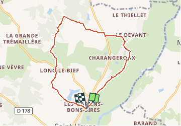
Randonnée Marche de 7,4 km à découvrir à Bourgogne-Franche-Comté, Saône-et-Loire, Saint-Usuge. Cette randonnée est proposée par erual71.

Description

Converted from a KML file KML2GPX.COM

Profil altimétrique

Localisation

Pays :
France
Région :
Bourgogne-Franche-Comté
Département/Province :
Saône-et-Loire
Commune :
Saint-Usuge
Localité :
Unknown
Départ:(Dec)
Départ:(UTM)
672530 ; 5172504 (31T) N.

Randonnées à proximité

Randonnée Marche Simard - G . Simard - Les Peutots - Le Perroir - la Voirie - Les Toines - et retour  - Photo
Marche
jeanpaulcheyssac

Marche

Difficile
Simard, Bourgogne-Franche-Comté, Saône-et-Loire, France
12,9 km | 13,9 km-effort
3h 9min
Oui
Randonnée A pied Branges - Circuit B - Photo
A pied
PRO

A pied

Facile
Branges, Bourgogne-Franche-Comté, Saône-et-Loire, France
3,2 km | 3,8 km-effort
51min
Oui
Randonnée Marche Saint-Usuge - St usuge - Photo
Marche
anpar

Marche

Difficile
Saint-Usuge, Bourgogne-Franche-Comté, Saône-et-Loire, France
11,5 km | 12,7 km-effort
2h 32min
Oui
Randonnée Marche Saint-Usuge - lethiellet-seille - Photo
Marche
Bernard3801

Marche

Moyen
Saint-Usuge, Bourgogne-Franche-Comté, Saône-et-Loire, France
6,6 km | 7,2 km-effort
1h 32min
Oui
Randonnée Marche Louhans - LOUHANS La passerelle - Photo
Marche
dominiq

Marche

Très facile
Louhans, Bourgogne-Franche-Comté, Saône-et-Loire, France
8,5 km | 9,3 km-effort
2h 15min
Oui
Randonnée Marche Montcony - Montcony_2023-10-28 - Photo
Marche
Phil.PES

Marche

Facile
Montcony, Bourgogne-Franche-Comté, Saône-et-Loire, France
4,6 km | 5,2 km-effort
57min
Oui
Randonnée Marche Montcony - Montcony_2023-10-27 - Photo
Marche
Phil.PES

Marche

Facile
Montcony, Bourgogne-Franche-Comté, Saône-et-Loire, France
3,4 km | 3,8 km-effort
47min
Oui
Randonnée Marche Louhans - torrent del far - Photo
Marche
Robmag

Marche

Difficile
Louhans, Bourgogne-Franche-Comté, Saône-et-Loire, France
477 km | 759 km-effort
3h 41min
Non
Randonnée Marche Saint-Usuge - saint Usuge - Photo
Marche
dominiq

Marche

Très facile
Saint-Usuge, Bourgogne-Franche-Comté, Saône-et-Loire, France
11 km | 12,3 km-effort
2h 31min
Oui


Fermer
Mes abonnements