![](/images/other/stat-length.png)
![Randonnée Marche Pont de Montvert - Sud Mont Lozère - Sentier de Mallevrière - Photo](https://media.geolcdn.com/t/1900/400/ext.pjpeg?maxdim=2&url=https%3A%2F%2Fstatic1.geolcdn.com%2Fsiteimages%2Fupload%2Ffiles%2F1553511878bg_sport_marche.png)
Sentier de Mallevrière
ja.13061965
Utilisateur
![Longueur](/images/other/stat-length.png)
Longueur
9,4 km
![Altitude max](https://static1.geolcdn.com/siteimages/upload/files/1508320355ic_sort_altitude_max_24dp.png)
Altitude max
1699 m
![Dénivelé positif](https://static1.geolcdn.com/siteimages/upload/files/1508320355ic_sort_den_pos_24dp.png)
Dénivelé positif
387 m
![Km-Effort](/images/other/stat-length.png)
Km-Effort
14,6 km
![Altitude min](https://static1.geolcdn.com/siteimages/upload/files/1508320355ic_sort_altitude_min_24dp.png)
Altitude min
1314 m
![Dénivelé négatif](https://static1.geolcdn.com/siteimages/upload/files/1508320355ic_sort_den_neg_24dp.png)
Dénivelé négatif
387 m
![Boucle](https://static1.geolcdn.com/siteimages/upload/files/16400158638029165_repeat_loop_refresh_sync_direction_icon.png)
Boucle
Oui
Date de création :
2020-06-25 08:19:38.084
Dernière modification :
2020-06-25 16:31:46.721
![Marche](https://static1.geolcdn.com/sitytour/trail-icons/101.png)
5h15
Difficulté : Facile
![Scannez ce code QR pour ouvrir la randonnée dans l'application SityTrail](https://capi.geolives.com/qq0zvz2zws4bq2lad0pu/sitytour/trails/2450400/qr.png?size=200)
Application GPS de randonnée GRATUITE
À propos
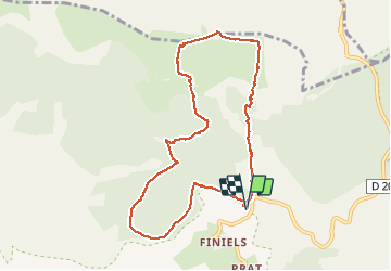
Randonnée Marche de 9,4 km à découvrir à Occitanie, Lozère, Pont de Montvert - Sud Mont Lozère. Cette randonnée est proposée par ja.13061965.
Description
Montée très agréable en sous bois. Mont Lozère incontournable. Descente tranquille sur GR et DFCI. Temps de parcours avec pique nique et flâneries...
Localisation
Pays :
France
Région :
Occitanie
Département/Province :
Lozère
Commune :
Pont de Montvert - Sud Mont Lozère
Localité :
Le Pont-de-Montvert
Départ:(Dec)
Départ:(UTM)
559683 ; 4917397 (31T) N.
Commentaires
Randonnées à proximité
![Randonnée V.T.T. Cubières - TOUR MONT LOZERE - Photo](https://media.geolcdn.com/t/375/260/a1bfdb58-8337-4d84-b53e-6cb2f940b716.jpeg&format=jpg&maxdim=2)
![V.T.T. V.T.T.](https://static1.geolcdn.com/sitytour/trail-icons/202.png)
TOUR MONT LOZERE
V.T.T.
Très difficile
(1)
Cubières,
Occitanie,
Lozère,
France
![](/images/other/stat-length.png)
38 km | 47 km-effort
3h 14min
![](https://static1.geolcdn.com/siteimages/upload/files/16400158638029165_repeat_loop_refresh_sync_direction_icon.png)
Oui
![Marche Marche](https://static1.geolcdn.com/sitytour/trail-icons/101.png)
Les prairies du col de Finiels et des monts Lozere
Marche
Moyen
(1)
Mont Lozère et Goulet,
Occitanie,
Lozère,
France
![](/images/other/stat-length.png)
7,2 km | 9,5 km-effort
2h 59min
![](https://static1.geolcdn.com/siteimages/upload/files/16400158638029165_repeat_loop_refresh_sync_direction_icon.png)
Oui
![Randonnée Marche Pont de Montvert - Sud Mont Lozère - Bédoues saint jean du Gard GR70 gr43 - Photo](https://media.geolcdn.com/t/375/260/c8a87bd6-9939-4680-8373-9b7fd4cfe94c.jpg&format=jpg&maxdim=2)
![Marche Marche](https://static1.geolcdn.com/sitytour/trail-icons/101.png)
Bédoues saint jean du Gard GR70 gr43
Marche
Très difficile
Pont de Montvert - Sud Mont Lozère,
Occitanie,
Lozère,
France
![](/images/other/stat-length.png)
86 km | 120 km-effort
26h 6min
![](https://static1.geolcdn.com/siteimages/upload/files/16400158638029165_repeat_loop_refresh_sync_direction_icon.png)
Non
![Randonnée Marche Pont de Montvert - Sud Mont Lozère - Stevenson pont de Monvert/ Bedouès - Photo](https://media.geolcdn.com/t/375/260/ecbe7c42-7ae5-463d-8ef8-0e93073f446d.jpg&format=jpg&maxdim=2)
![Marche Marche](https://static1.geolcdn.com/sitytour/trail-icons/101.png)
Stevenson pont de Monvert/ Bedouès
Marche
Difficile
Pont de Montvert - Sud Mont Lozère,
Occitanie,
Lozère,
France
![](/images/other/stat-length.png)
26 km | 38 km-effort
7h 29min
![](https://static1.geolcdn.com/siteimages/upload/files/16400158638029165_repeat_loop_refresh_sync_direction_icon.png)
Non
![Randonnée Marche Pont de Montvert - Sud Mont Lozère - 13-05-2023 E8 Le Pont de Monvers - Bédouès - Photo](https://media.geolcdn.com/t/375/260/e57cdaa9-bdeb-4cef-90ee-76cf38da3fbe.jpg&format=jpg&maxdim=2)
![Marche Marche](https://static1.geolcdn.com/sitytour/trail-icons/101.png)
13-05-2023 E8 Le Pont de Monvers - Bédouès
Marche
Très difficile
Pont de Montvert - Sud Mont Lozère,
Occitanie,
Lozère,
France
![](/images/other/stat-length.png)
25 km | 37 km-effort
8h 19min
![](https://static1.geolcdn.com/siteimages/upload/files/16400158638029165_repeat_loop_refresh_sync_direction_icon.png)
Non
![Randonnée Marche Pont de Montvert - Sud Mont Lozère - Finiels/ sommet / station du Bleymard en boucle - Photo](https://media.geolcdn.com/t/375/260/f8048304-3a05-4fd0-a0e7-03457722fcee.jpg&format=jpg&maxdim=2)
![Marche Marche](https://static1.geolcdn.com/sitytour/trail-icons/101.png)
Finiels/ sommet / station du Bleymard en boucle
Marche
Difficile
Pont de Montvert - Sud Mont Lozère,
Occitanie,
Lozère,
France
![](/images/other/stat-length.png)
20 km | 30 km-effort
5h 38min
![](https://static1.geolcdn.com/siteimages/upload/files/16400158638029165_repeat_loop_refresh_sync_direction_icon.png)
Oui
![Randonnée Marche Pont de Montvert - Sud Mont Lozère - J6 Stevenson: Pont de Monvert - Cassagnas - Photo](https://media.geolcdn.com/t/375/260/ext.jpg?maxdim=2&url=https%3A%2F%2Fstatic1.geolcdn.com%2Fsiteimages%2Fupload%2Ffiles%2F1553511878bg_sport_marche.png)
![Marche Marche](https://static1.geolcdn.com/sitytour/trail-icons/101.png)
J6 Stevenson: Pont de Monvert - Cassagnas
Marche
Moyen
(1)
Pont de Montvert - Sud Mont Lozère,
Occitanie,
Lozère,
France
![](/images/other/stat-length.png)
19,7 km | 29 km-effort
5h 58min
![](https://static1.geolcdn.com/siteimages/upload/files/16400158638029165_repeat_loop_refresh_sync_direction_icon.png)
Non
![Randonnée Marche Pont de Montvert - Sud Mont Lozère - Cévennes Mas Camargues Pont du Tarn - Photo](https://media.geolcdn.com/t/375/260/ext.jpg?maxdim=2&url=https%3A%2F%2Fservices.sitytrail.com%2FGeolivesWS%2FDownloadMedia.ashx%3FTrailID%3D345700%26Media%3Dfix__20140916143911.jpg)
![Marche Marche](https://static1.geolcdn.com/sitytour/trail-icons/101.png)
Cévennes Mas Camargues Pont du Tarn
Marche
Facile
(1)
Pont de Montvert - Sud Mont Lozère,
Occitanie,
Lozère,
France
![](/images/other/stat-length.png)
7,4 km | 8,6 km-effort
2h 7min
![](https://static1.geolcdn.com/siteimages/upload/files/16400158638029165_repeat_loop_refresh_sync_direction_icon.png)
Oui
![Randonnée Marche Mont Lozère et Goulet - sources du tarn - Photo](https://media.geolcdn.com/t/375/260/ext.jpg?maxdim=2&url=https%3A%2F%2Fstatic1.geolcdn.com%2Fsiteimages%2Fupload%2Ffiles%2F1553511878bg_sport_marche.png)
![Marche Marche](https://static1.geolcdn.com/sitytour/trail-icons/101.png)
sources du tarn
Marche
Moyen
(1)
Mont Lozère et Goulet,
Occitanie,
Lozère,
France
![](/images/other/stat-length.png)
13,3 km | 17,3 km-effort
3h 50min
![](https://static1.geolcdn.com/siteimages/upload/files/16400158638029165_repeat_loop_refresh_sync_direction_icon.png)
Non