![](/images/other/stat-length.png)
![Randonnée Marche Lescun - Lac et cabane de l'Hurs - Photo](https://media.geolcdn.com/t/1900/400/36682967-24aa-4c4c-bc05-a12cf603d09b.jpg&format=pjpeg&maxdim=2)
Lac et cabane de l'Hurs
bedous
Utilisateur
![Longueur](/images/other/stat-length.png)
Longueur
9,7 km
![Altitude max](https://static1.geolcdn.com/siteimages/upload/files/1508320355ic_sort_altitude_max_24dp.png)
Altitude max
1729 m
![Dénivelé positif](https://static1.geolcdn.com/siteimages/upload/files/1508320355ic_sort_den_pos_24dp.png)
Dénivelé positif
649 m
![Km-Effort](/images/other/stat-length.png)
Km-Effort
18,3 km
![Altitude min](https://static1.geolcdn.com/siteimages/upload/files/1508320355ic_sort_altitude_min_24dp.png)
Altitude min
1087 m
![Dénivelé négatif](https://static1.geolcdn.com/siteimages/upload/files/1508320355ic_sort_den_neg_24dp.png)
Dénivelé négatif
648 m
![Boucle](https://static1.geolcdn.com/siteimages/upload/files/16400158638029165_repeat_loop_refresh_sync_direction_icon.png)
Boucle
Oui
Date de création :
2020-06-24 06:01:56.649
Dernière modification :
2020-06-24 14:01:42.763
![Marche](https://static1.geolcdn.com/sitytour/trail-icons/101.png)
4h39
Difficulté : Difficile
![Scannez ce code QR pour ouvrir la randonnée dans l'application SityTrail](https://capi.geolives.com/qq0zvz2zws4bq2lad0pu/sitytour/trails/2448704/qr.png?size=200)
Application GPS de randonnée GRATUITE
À propos
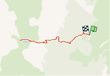
Randonnée Marche de 9,7 km à découvrir à Nouvelle-Aquitaine, Pyrénées-Atlantiques, Lescun. Cette randonnée est proposée par bedous.
Description
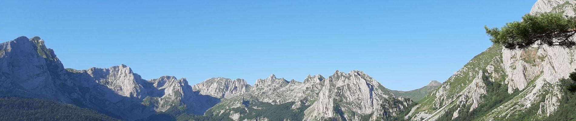
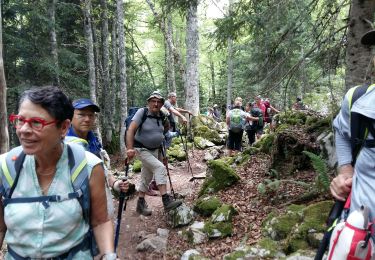
Vallée d'Aspe. Lescun. La randonnée sur les 2/3 inférieurs s'effectue sous bois puis dans un milieu minéral. Pente trés forte.
Localisation
Pays :
France
Région :
Nouvelle-Aquitaine
Département/Province :
Pyrénées-Atlantiques
Commune :
Lescun
Localité :
Unknown
Départ:(Dec)
Départ:(UTM)
690291 ; 4755032 (30T) N.
Commentaires
Randonnées à proximité
![Randonnée Marche Lescun - Le plateau de Sanchèse - Lescun - Photo](https://media.geolcdn.com/t/375/260/ext.jpg?maxdim=2&url=https%3A%2F%2Fservices.sitytrail.com%2FGeolivesWS%2FDownloadMedia.ashx%3FTrailID%3D111284%26Media%3D6928_1.jpg)
![Marche Marche](https://static1.geolcdn.com/sitytour/trail-icons/101.png)
Le plateau de Sanchèse - Lescun
Marche
Facile
(2)
Lescun,
Nouvelle-Aquitaine,
Pyrénées-Atlantiques,
France
![](/images/other/stat-length.png)
5,4 km | 7,4 km-effort
2h 0min
![](https://static1.geolcdn.com/siteimages/upload/files/16400158638029165_repeat_loop_refresh_sync_direction_icon.png)
Oui
![Randonnée Marche Lescun - Lac de Lhurs - Photo](https://media.geolcdn.com/t/375/260/ext.jpg?maxdim=2&url=https%3A%2F%2Fservices.sitytrail.com%2FGeolivesWS%2FDownloadMedia.ashx%3FTrailID%3D106243%26Media%3D10574_1.jpg)
![Marche Marche](https://static1.geolcdn.com/sitytour/trail-icons/101.png)
Lac de Lhurs
Marche
Moyen
(2)
Lescun,
Nouvelle-Aquitaine,
Pyrénées-Atlantiques,
France
![](/images/other/stat-length.png)
9,5 km | 19,2 km-effort
4h 0min
![](https://static1.geolcdn.com/siteimages/upload/files/16400158638029165_repeat_loop_refresh_sync_direction_icon.png)
Oui
![Randonnée A pied Lescun - Cabanes et Lac de Lhurs asp51 - Photo](https://media.geolcdn.com/t/375/260/6a266a45-7e80-4faa-8425-ef35e57a7e4a.jpeg&format=jpg&maxdim=2)
![A pied A pied](https://static1.geolcdn.com/sitytour/trail-icons/100.png)
Cabanes et Lac de Lhurs asp51
A pied
Facile
Lescun,
Nouvelle-Aquitaine,
Pyrénées-Atlantiques,
France
![](/images/other/stat-length.png)
5,9 km | 13,2 km-effort
2h 59min
![](https://static1.geolcdn.com/siteimages/upload/files/16400158638029165_repeat_loop_refresh_sync_direction_icon.png)
Non
![Randonnée A pied Lées-Athas - Chemin d'Esquit à Lescun asp46 - Photo](https://media.geolcdn.com/t/375/260/f2e56414-5888-41b7-b503-d53feec7e149.jpeg&format=jpg&maxdim=2)
![A pied A pied](https://static1.geolcdn.com/sitytour/trail-icons/100.png)
Chemin d'Esquit à Lescun asp46
A pied
Facile
Lées-Athas,
Nouvelle-Aquitaine,
Pyrénées-Atlantiques,
France
![](/images/other/stat-length.png)
8 km | 15,6 km-effort
3h 32min
![](https://static1.geolcdn.com/siteimages/upload/files/16400158638029165_repeat_loop_refresh_sync_direction_icon.png)
Non
![Randonnée A pied Lescun - Tour du Belvédère asp47 - Photo](https://media.geolcdn.com/t/375/260/3d73b6d7-975c-44ff-8d63-4ea540b69f0c.jpeg&format=jpg&maxdim=2)
![A pied A pied](https://static1.geolcdn.com/sitytour/trail-icons/100.png)
Tour du Belvédère asp47
A pied
Facile
Lescun,
Nouvelle-Aquitaine,
Pyrénées-Atlantiques,
France
![](/images/other/stat-length.png)
4,4 km | 8,9 km-effort
2h 1min
![](https://static1.geolcdn.com/siteimages/upload/files/16400158638029165_repeat_loop_refresh_sync_direction_icon.png)
Oui
![Randonnée A pied Lescun - Refuge de Linza par le Col de Pétragème asp119 - Photo](https://media.geolcdn.com/t/375/260/96f1c4ac-fbcc-4ef8-930f-02b32609dc3b.jpeg&format=jpg&maxdim=2)
![A pied A pied](https://static1.geolcdn.com/sitytour/trail-icons/100.png)
Refuge de Linza par le Col de Pétragème asp119
A pied
Moyen
Lescun,
Nouvelle-Aquitaine,
Pyrénées-Atlantiques,
France
![](/images/other/stat-length.png)
13,1 km | 27 km-effort
6h 14min
![](https://static1.geolcdn.com/siteimages/upload/files/16400158638029165_repeat_loop_refresh_sync_direction_icon.png)
Non
![Randonnée Marche Lescun - Cirque de Lescun - Photo](https://media.geolcdn.com/t/375/260/d435ee66-b9e1-4e5f-a628-c21e49952bda.jpg&format=jpg&maxdim=2)
![Marche Marche](https://static1.geolcdn.com/sitytour/trail-icons/101.png)
Cirque de Lescun
Marche
Moyen
(1)
Lescun,
Nouvelle-Aquitaine,
Pyrénées-Atlantiques,
France
![](/images/other/stat-length.png)
5,5 km | 7,8 km-effort
1h 46min
![](https://static1.geolcdn.com/siteimages/upload/files/16400158638029165_repeat_loop_refresh_sync_direction_icon.png)
Oui
![Randonnée Marche Lescun - LESCUN Laberouat pas d azun LPC G3/G4](https://media.geolcdn.com/t/375/260/a3daf2b3-33fd-42e3-9a30-72a4d9ba5438.jpg&format=jpg&maxdim=2)
![Marche Marche](https://static1.geolcdn.com/sitytour/trail-icons/101.png)
LESCUN Laberouat pas d azun LPC G3/G4 "2915056"
Marche
Difficile
Lescun,
Nouvelle-Aquitaine,
Pyrénées-Atlantiques,
France
![](/images/other/stat-length.png)
9,4 km | 15,5 km-effort
3h 15min
![](https://static1.geolcdn.com/siteimages/upload/files/16400158638029165_repeat_loop_refresh_sync_direction_icon.png)
Oui
![Randonnée Marche Lescun - Lac d'Ansabère suivi du lac d'Achérito - Photo](https://media.geolcdn.com/t/375/260/fd869a8e-5d55-44ff-869b-208fcab21b96.jpg&format=jpg&maxdim=2)
![Marche Marche](https://static1.geolcdn.com/sitytour/trail-icons/101.png)
Lac d'Ansabère suivi du lac d'Achérito
Marche
Difficile
Lescun,
Nouvelle-Aquitaine,
Pyrénées-Atlantiques,
France
![](/images/other/stat-length.png)
12,3 km | 25 km-effort
5h 35min
![](https://static1.geolcdn.com/siteimages/upload/files/16400158638029165_repeat_loop_refresh_sync_direction_icon.png)
Oui