![](/images/other/stat-length.png)
![Randonnée Marche Montgé-en-Goële - MR_MONTGEenGOELE_5.7km - Photo](https://media.geolcdn.com/t/1900/400/ext.pjpeg?maxdim=2&url=https%3A%2F%2Fstatic1.geolcdn.com%2Fsiteimages%2Fupload%2Ffiles%2F1553511878bg_sport_marche.png)
MR_MONTGEenGOELE_5.7km
GOELERANDO2
Utilisateur
![Longueur](/images/other/stat-length.png)
Longueur
5,7 km
![Altitude max](https://static1.geolcdn.com/siteimages/upload/files/1508320355ic_sort_altitude_max_24dp.png)
Altitude max
209 m
![Dénivelé positif](https://static1.geolcdn.com/siteimages/upload/files/1508320355ic_sort_den_pos_24dp.png)
Dénivelé positif
107 m
![Km-Effort](/images/other/stat-length.png)
Km-Effort
7,1 km
![Altitude min](https://static1.geolcdn.com/siteimages/upload/files/1508320355ic_sort_altitude_min_24dp.png)
Altitude min
133 m
![Dénivelé négatif](https://static1.geolcdn.com/siteimages/upload/files/1508320355ic_sort_den_neg_24dp.png)
Dénivelé négatif
107 m
![Boucle](https://static1.geolcdn.com/siteimages/upload/files/16400158638029165_repeat_loop_refresh_sync_direction_icon.png)
Boucle
Oui
Date de création :
2020-06-24 08:59:13.692
Dernière modification :
2020-06-24 09:05:28.76
![Marche](https://static1.geolcdn.com/sitytour/trail-icons/101.png)
1h31
Difficulté : Moyen
![Scannez ce code QR pour ouvrir la randonnée dans l'application SityTrail](https://capi.geolives.com/qq0zvz2zws4bq2lad0pu/sitytour/trails/2448556/qr.png?size=200)
Application GPS de randonnée GRATUITE
À propos
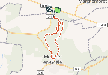
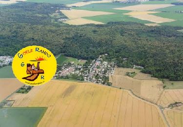
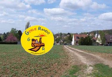
Randonnée Marche de 5,7 km à découvrir à Île-de-France, Seine-et-Marne, Montgé-en-Goële. Cette randonnée est proposée par GOELERANDO2.
Description
randonnée au cœur du parc de St Thibault
Départ au choix des parkings sur le D41 ou au sommet du Domaine près du centre équestre de Montgé en Goêle 77
Localisation
Pays :
France
Région :
Île-de-France
Département/Province :
Seine-et-Marne
Commune :
Montgé-en-Goële
Localité :
Unknown
Départ:(Dec)
Départ:(UTM)
481654 ; 5432428 (31U) N.
Commentaires
Randonnées à proximité
![Randonnée Marche Vinantes - SM_VINANTES_7.9Km - Photo](https://media.geolcdn.com/t/375/260/13298252-6192-4688-8560-e862227f2560.jpg&format=jpg&maxdim=2)
![Marche Marche](https://static1.geolcdn.com/sitytour/trail-icons/101.png)
SM_VINANTES_7.9Km
Marche
Moyen
(5)
Vinantes,
Île-de-France,
Seine-et-Marne,
France
![](/images/other/stat-length.png)
7,9 km | 8,9 km-effort
2h 1min
![](https://static1.geolcdn.com/siteimages/upload/files/16400158638029165_repeat_loop_refresh_sync_direction_icon.png)
Oui
![Randonnée Marche Montgé-en-Goële - MR_MONTGE-en-GOELE_5.3Km - Photo](https://media.geolcdn.com/t/375/260/35addc96-117d-441b-96c3-8a9f60ce0ef4.jpg&format=jpg&maxdim=2)
![Marche Marche](https://static1.geolcdn.com/sitytour/trail-icons/101.png)
MR_MONTGE-en-GOELE_5.3Km
Marche
Moyen
(5)
Montgé-en-Goële,
Île-de-France,
Seine-et-Marne,
France
![](/images/other/stat-length.png)
5,3 km | 6,8 km-effort
1h 32min
![](https://static1.geolcdn.com/siteimages/upload/files/16400158638029165_repeat_loop_refresh_sync_direction_icon.png)
Oui
![Randonnée A pied Saint-Mard - Formation SITY TRAIL_SAINT MARD - Photo](https://media.geolcdn.com/t/375/260/ba3d62a0-8f58-458e-9ed8-b3b717ccdf4f.jpg&format=jpg&maxdim=2)
![A pied A pied](https://static1.geolcdn.com/sitytour/trail-icons/100.png)
Formation SITY TRAIL_SAINT MARD
A pied
Très facile
(3)
Saint-Mard,
Île-de-France,
Seine-et-Marne,
France
![](/images/other/stat-length.png)
3,6 km | 4,4 km-effort
Inconnu
![](https://static1.geolcdn.com/siteimages/upload/files/16400158638029165_repeat_loop_refresh_sync_direction_icon.png)
Oui
![Randonnée Marche Cuisy - SM_CUISY_7Km - Photo](https://media.geolcdn.com/t/375/260/6ba8652c-8bb0-4a43-980a-678cd2edacc0.jpg&format=jpg&maxdim=2)
![Marche Marche](https://static1.geolcdn.com/sitytour/trail-icons/101.png)
SM_CUISY_7Km
Marche
Moyen
(4)
Cuisy,
Île-de-France,
Seine-et-Marne,
France
![](/images/other/stat-length.png)
7 km | 8,7 km-effort
2h 21min
![](https://static1.geolcdn.com/siteimages/upload/files/16400158638029165_repeat_loop_refresh_sync_direction_icon.png)
Oui
![Randonnée Marche Montgé-en-Goële - SM_Montgé en Goële_8Km - Photo](https://media.geolcdn.com/t/375/260/512ace96-07d5-42e9-972d-de3ead1e1b12.jpg&format=jpg&maxdim=2)
![Marche Marche](https://static1.geolcdn.com/sitytour/trail-icons/101.png)
SM_Montgé en Goële_8Km
Marche
Moyen
(3)
Montgé-en-Goële,
Île-de-France,
Seine-et-Marne,
France
![](/images/other/stat-length.png)
8 km | 9,7 km-effort
2h 12min
![](https://static1.geolcdn.com/siteimages/upload/files/16400158638029165_repeat_loop_refresh_sync_direction_icon.png)
Oui
![Randonnée Marche Vinantes - SM_VINANTES (par Montgé)_8.2Km - Photo](https://media.geolcdn.com/t/375/260/13298252-6192-4688-8560-e862227f2560.jpg&format=jpg&maxdim=2)
![Marche Marche](https://static1.geolcdn.com/sitytour/trail-icons/101.png)
SM_VINANTES (par Montgé)_8.2Km
Marche
Moyen
(1)
Vinantes,
Île-de-France,
Seine-et-Marne,
France
![](/images/other/stat-length.png)
8,1 km | 9,6 km-effort
2h 10min
![](https://static1.geolcdn.com/siteimages/upload/files/16400158638029165_repeat_loop_refresh_sync_direction_icon.png)
Oui
![Randonnée Marche Le Plessis-l'Évêque - MR_PLESSIS-L'EVEQUE_4.9Km - Photo](https://media.geolcdn.com/t/375/260/47f97308-fc93-4ea9-9c1c-fa82b0f1a452.jpg&format=jpg&maxdim=2)
![Marche Marche](https://static1.geolcdn.com/sitytour/trail-icons/101.png)
MR_PLESSIS-L'EVEQUE_4.9Km
Marche
Facile
(3)
Le Plessis-l'Évêque,
Île-de-France,
Seine-et-Marne,
France
![](/images/other/stat-length.png)
4,9 km | 5,5 km-effort
1h 12min
![](https://static1.geolcdn.com/siteimages/upload/files/16400158638029165_repeat_loop_refresh_sync_direction_icon.png)
Oui
![Randonnée Marche Saint-Mard - Le tour du grand Paris via le GR1 Etape 9 Dammartin en Goele - Meaux - Photo](https://media.geolcdn.com/t/375/260/c2b9ac23-3f31-4bcb-a8f1-c9edbe9e7c1b.jpg&format=jpg&maxdim=2)
![Marche Marche](https://static1.geolcdn.com/sitytour/trail-icons/101.png)
Le tour du grand Paris via le GR1 Etape 9 Dammartin en Goele - Meaux
Marche
Moyen
Saint-Mard,
Île-de-France,
Seine-et-Marne,
France
![](/images/other/stat-length.png)
22 km | 26 km-effort
5h 43min
![](https://static1.geolcdn.com/siteimages/upload/files/16400158638029165_repeat_loop_refresh_sync_direction_icon.png)
Non
![Randonnée Marche Montgé-en-Goële - Montgé en Goële SuperMiniRando - Photo](https://media.geolcdn.com/t/375/260/ext.jpg?maxdim=2&url=https%3A%2F%2Fstatic1.geolcdn.com%2Fsiteimages%2Fupload%2Ffiles%2F1553511878bg_sport_marche.png)
![Marche Marche](https://static1.geolcdn.com/sitytour/trail-icons/101.png)
Montgé en Goële SuperMiniRando
Marche
Facile
(1)
Montgé-en-Goële,
Île-de-France,
Seine-et-Marne,
France
![](/images/other/stat-length.png)
8 km | 9,6 km-effort
1h 59min
![](https://static1.geolcdn.com/siteimages/upload/files/16400158638029165_repeat_loop_refresh_sync_direction_icon.png)
Oui