![](/images/other/stat-length.png)
![Randonnée Marche Saint-Roman-de-Codières - Col de Pierre Levée Serre du Cambon - Photo](https://media.geolcdn.com/t/1900/400/ext.pjpeg?maxdim=2&url=https%3A%2F%2Fservices.sitytrail.com%2FGeolivesWS%2FDownloadMedia.ashx%3FTrailID%3D244730%26Media%3D20140125171620.jpg)
Col de Pierre Levée Serre du Cambon
zoe.vienne
Utilisateur
![Longueur](/images/other/stat-length.png)
Longueur
9,8 km
![Altitude max](https://static1.geolcdn.com/siteimages/upload/files/1508320355ic_sort_altitude_max_24dp.png)
Altitude max
790 m
![Dénivelé positif](https://static1.geolcdn.com/siteimages/upload/files/1508320355ic_sort_den_pos_24dp.png)
Dénivelé positif
413 m
![Km-Effort](/images/other/stat-length.png)
Km-Effort
15,3 km
![Altitude min](https://static1.geolcdn.com/siteimages/upload/files/1508320355ic_sort_altitude_min_24dp.png)
Altitude min
545 m
![Dénivelé négatif](https://static1.geolcdn.com/siteimages/upload/files/1508320355ic_sort_den_neg_24dp.png)
Dénivelé négatif
413 m
![Boucle](https://static1.geolcdn.com/siteimages/upload/files/16400158638029165_repeat_loop_refresh_sync_direction_icon.png)
Boucle
Oui
Date de création :
2014-12-10 00:00:00.0
Dernière modification :
2014-12-10 00:00:00.0
![Marche](https://static1.geolcdn.com/sitytour/trail-icons/101.png)
2h57
Difficulté : Facile
![Scannez ce code QR pour ouvrir la randonnée dans l'application SityTrail](https://capi.geolives.com/qq0zvz2zws4bq2lad0pu/sitytour/trails/244730/qr.png?size=200)
Application GPS de randonnée GRATUITE
À propos
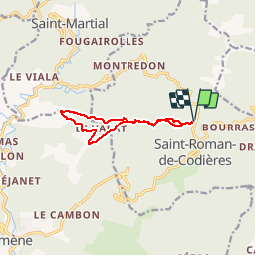
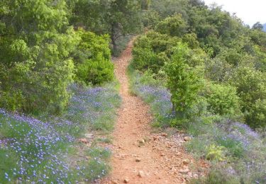
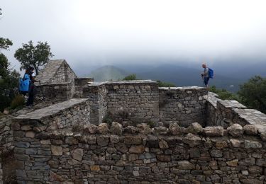
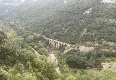
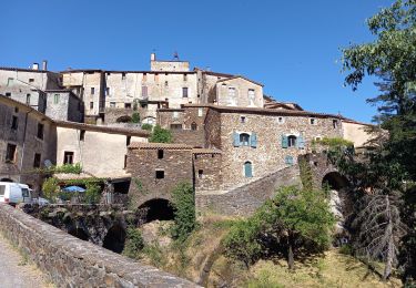
Randonnée Marche de 9,8 km à découvrir à Occitanie, Gard, Saint-Roman-de-Codières. Cette randonnée est proposée par zoe.vienne.
Description
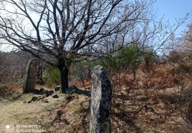
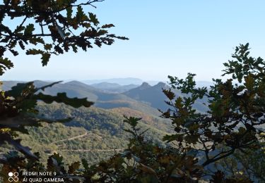
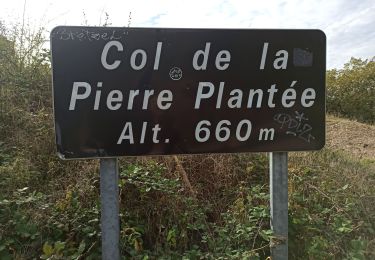
Belle boucle pour randonneurs avertis. Quelques passages peu évidents une boussole est de rigueur ainsi qu'une carte à jour...
Localisation
Pays :
France
Région :
Occitanie
Département/Province :
Gard
Commune :
Saint-Roman-de-Codières
Localité :
Unknown
Départ:(Dec)
Départ:(UTM)
562395 ; 4873348 (31T) N.
Commentaires
Randonnées à proximité
![Randonnée Marche Sumène - Le Ranc de Banes - Sumène - Photo](https://media.geolcdn.com/t/375/260/ext.jpg?maxdim=2&url=https%3A%2F%2Fservices.sitytrail.com%2FGeolivesWS%2FDownloadMedia.ashx%3FTrailID%3D106716%26Media%3D11360_5.jpg)
![Marche Marche](https://static1.geolcdn.com/sitytour/trail-icons/101.png)
Le Ranc de Banes - Sumène
Marche
Difficile
(1)
Sumène,
Occitanie,
Gard,
France
![](/images/other/stat-length.png)
13,3 km | 24 km-effort
6h 0min
![](https://static1.geolcdn.com/siteimages/upload/files/16400158638029165_repeat_loop_refresh_sync_direction_icon.png)
Oui
![Randonnée Marche Sumène - Ranc de Banes et les Jumeaux - Photo](https://media.geolcdn.com/t/375/260/98f32182-811b-4f0a-9295-196a455ecf2f.jpg&format=jpg&maxdim=2)
![Marche Marche](https://static1.geolcdn.com/sitytour/trail-icons/101.png)
Ranc de Banes et les Jumeaux
Marche
Difficile
Sumène,
Occitanie,
Gard,
France
![](/images/other/stat-length.png)
17,6 km | 29 km-effort
6h 8min
![](https://static1.geolcdn.com/siteimages/upload/files/16400158638029165_repeat_loop_refresh_sync_direction_icon.png)
Oui
![Randonnée Marche La Cadière-et-Cambo - CAMBO - MONTAGNE DE LA FAGE - 7.6Km - 02h20 - Dénivelé 285 m - Photo](https://media.geolcdn.com/t/375/260/ext.jpg?maxdim=2&url=https%3A%2F%2Fstatic1.geolcdn.com%2Fsiteimages%2Fupload%2Ffiles%2F1553511878bg_sport_marche.png)
![Marche Marche](https://static1.geolcdn.com/sitytour/trail-icons/101.png)
CAMBO - MONTAGNE DE LA FAGE - 7.6Km - 02h20 - Dénivelé 285 m
Marche
Moyen
(1)
La Cadière-et-Cambo,
Occitanie,
Gard,
France
![](/images/other/stat-length.png)
7,6 km | 11,2 km-effort
2h 29min
![](https://static1.geolcdn.com/siteimages/upload/files/16400158638029165_repeat_loop_refresh_sync_direction_icon.png)
Oui
![Randonnée Marche Sumène - Sumene , le pont des chèvres - Photo](https://media.geolcdn.com/t/375/260/ed181aaa-ab94-42d0-bcb4-df9a435a052b.jpg&format=jpg&maxdim=2)
![Marche Marche](https://static1.geolcdn.com/sitytour/trail-icons/101.png)
Sumene , le pont des chèvres
Marche
Moyen
Sumène,
Occitanie,
Gard,
France
![](/images/other/stat-length.png)
10,9 km | 15,3 km-effort
3h 11min
![](https://static1.geolcdn.com/siteimages/upload/files/16400158638029165_repeat_loop_refresh_sync_direction_icon.png)
Oui
![Randonnée A pied Colognac - 30 du Cayrel au Camp Barrat 20/02/24 - Photo](https://media.geolcdn.com/t/375/260/db46be15-0ade-41ce-a4c3-6381b880347f.jpg&format=jpg&maxdim=2)
![A pied A pied](https://static1.geolcdn.com/sitytour/trail-icons/100.png)
30 du Cayrel au Camp Barrat 20/02/24
A pied
Moyen
Colognac,
Occitanie,
Gard,
France
![](/images/other/stat-length.png)
16 km | 25 km-effort
5h 38min
![](https://static1.geolcdn.com/siteimages/upload/files/16400158638029165_repeat_loop_refresh_sync_direction_icon.png)
Oui
![Randonnée Marche Sumène - 30 les crêtes des cagnasses,a la fage 15/11/23 - Photo](https://media.geolcdn.com/t/375/260/327f6ae4-95a4-43dc-ae64-f238198e92ec.jpg&format=jpg&maxdim=2)
![Marche Marche](https://static1.geolcdn.com/sitytour/trail-icons/101.png)
30 les crêtes des cagnasses,a la fage 15/11/23
Marche
Très difficile
Sumène,
Occitanie,
Gard,
France
![](/images/other/stat-length.png)
17 km | 26 km-effort
5h 13min
![](https://static1.geolcdn.com/siteimages/upload/files/16400158638029165_repeat_loop_refresh_sync_direction_icon.png)
Oui
![Randonnée Marche Saint-Roman-de-Codières - st roman de codieres - Photo](https://media.geolcdn.com/t/375/260/20d79857-0660-4ad5-8bfa-f1464b2570fb.jpg&format=jpg&maxdim=2)
![Marche Marche](https://static1.geolcdn.com/sitytour/trail-icons/101.png)
st roman de codieres
Marche
Moyen
Saint-Roman-de-Codières,
Occitanie,
Gard,
France
![](/images/other/stat-length.png)
16,2 km | 24 km-effort
6h 11min
![](https://static1.geolcdn.com/siteimages/upload/files/16400158638029165_repeat_loop_refresh_sync_direction_icon.png)
Oui
![Randonnée Marche Saint-Martial - Montagne du Liron au départ de St Martial - Photo](https://media.geolcdn.com/t/375/260/230ffbae-9a5c-40a3-841b-ca21b92f7b5b.jpg&format=jpg&maxdim=2)
![Marche Marche](https://static1.geolcdn.com/sitytour/trail-icons/101.png)
Montagne du Liron au départ de St Martial
Marche
Difficile
Saint-Martial,
Occitanie,
Gard,
France
![](/images/other/stat-length.png)
19,4 km | 32 km-effort
7h 4min
![](https://static1.geolcdn.com/siteimages/upload/files/16400158638029165_repeat_loop_refresh_sync_direction_icon.png)
Oui
![Randonnée Marche Saint-Roman-de-Codières - St Roman de Codiere 2 - Photo](https://media.geolcdn.com/t/375/260/eecdea35-1ea5-474d-b466-cf9b8758dea8.jpg&format=jpg&maxdim=2)
![Marche Marche](https://static1.geolcdn.com/sitytour/trail-icons/101.png)
St Roman de Codiere 2
Marche
Moyen
Saint-Roman-de-Codières,
Occitanie,
Gard,
France
![](/images/other/stat-length.png)
13,7 km | 20 km-effort
4h 36min
![](https://static1.geolcdn.com/siteimages/upload/files/16400158638029165_repeat_loop_refresh_sync_direction_icon.png)
Oui