![](/images/other/stat-length.png)
![Randonnée Marche Bolquère - Bolquère .Petit Canada Pla de Barrès - Photo](https://media.geolcdn.com/t/1900/400/adc3778b-e47b-4e63-8301-cbcefac67c9c.jpg&format=pjpeg&maxdim=2)
Bolquère .Petit Canada Pla de Barrès
MarieFrancoise
Utilisateur
![Longueur](/images/other/stat-length.png)
Longueur
4,7 km
![Altitude max](https://static1.geolcdn.com/siteimages/upload/files/1508320355ic_sort_altitude_max_24dp.png)
Altitude max
1662 m
![Dénivelé positif](https://static1.geolcdn.com/siteimages/upload/files/1508320355ic_sort_den_pos_24dp.png)
Dénivelé positif
40 m
![Km-Effort](/images/other/stat-length.png)
Km-Effort
5,3 km
![Altitude min](https://static1.geolcdn.com/siteimages/upload/files/1508320355ic_sort_altitude_min_24dp.png)
Altitude min
1648 m
![Dénivelé négatif](https://static1.geolcdn.com/siteimages/upload/files/1508320355ic_sort_den_neg_24dp.png)
Dénivelé négatif
39 m
![Boucle](https://static1.geolcdn.com/siteimages/upload/files/16400158638029165_repeat_loop_refresh_sync_direction_icon.png)
Boucle
Oui
Date de création :
2020-06-22 14:12:27.81
Dernière modification :
2020-06-22 16:19:10.66
![Marche](https://static1.geolcdn.com/sitytour/trail-icons/101.png)
2h06
Difficulté : Très facile
![Scannez ce code QR pour ouvrir la randonnée dans l'application SityTrail](https://capi.geolives.com/qq0zvz2zws4bq2lad0pu/sitytour/trails/2446734/qr.png?size=200)
Application GPS de randonnée GRATUITE
À propos
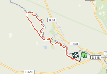
Randonnée Marche de 4,7 km à découvrir à Occitanie, Pyrénées-Orientales, Bolquère. Cette randonnée est proposée par MarieFrancoise.
Description
Départ du parking à côté de la déchetterie de Bolquère sur la route allant à Font Romeu
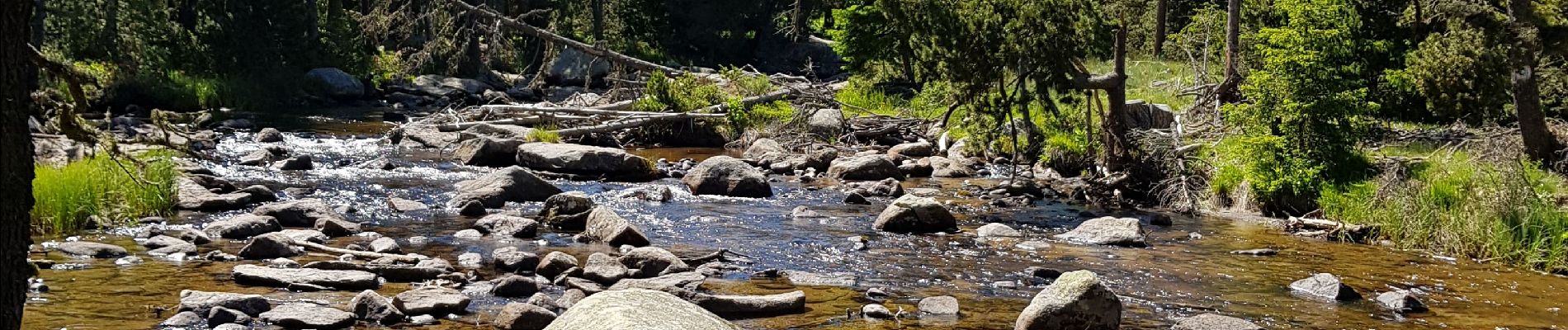
Très jolie balade en forêt le long de la rivière de la Têt .Très facile pour toute la famille.
Localisation
Pays :
France
Région :
Occitanie
Département/Province :
Pyrénées-Orientales
Commune :
Bolquère
Localité :
Unknown
Départ:(Dec)
Départ:(UTM)
426345 ; 4707181 (31T) N.
Commentaires
Randonnées à proximité
![Randonnée Marche Eyne - Eyne,col de Nuria,pic d'Eyne,Torre d'Eyne,Eyne. - Photo](https://media.geolcdn.com/t/375/260/ext.jpg?maxdim=2&url=https%3A%2F%2Fservices.sitytrail.com%2FGeolivesWS%2FDownloadMedia.ashx%3FTrailID%3D530520%26Media%3D20150811115220.jpg)
![Marche Marche](https://static1.geolcdn.com/sitytour/trail-icons/101.png)
Eyne,col de Nuria,pic d'Eyne,Torre d'Eyne,Eyne.
Marche
Très difficile
(1)
Eyne,
Occitanie,
Pyrénées-Orientales,
France
![](/images/other/stat-length.png)
24 km | 43 km-effort
8h 44min
![](https://static1.geolcdn.com/siteimages/upload/files/16400158638029165_repeat_loop_refresh_sync_direction_icon.png)
Oui
![Randonnée Marche Planès - étang de Planès - Photo](https://media.geolcdn.com/t/375/260/ext.jpg?maxdim=2&url=https%3A%2F%2Fservices.sitytrail.com%2FGeolivesWS%2FDownloadMedia.ashx%3FTrailID%3D330882%26Media%3Dfix__20140804135744.jpg)
![Marche Marche](https://static1.geolcdn.com/sitytour/trail-icons/101.png)
étang de Planès
Marche
Moyen
(2)
Planès,
Occitanie,
Pyrénées-Orientales,
France
![](/images/other/stat-length.png)
10,8 km | 19,6 km-effort
3h 54min
![](https://static1.geolcdn.com/siteimages/upload/files/16400158638029165_repeat_loop_refresh_sync_direction_icon.png)
Non
![Randonnée Marche Eyne - Le Cambre d'Ase - Photo](https://media.geolcdn.com/t/375/260/ext.jpg?maxdim=2&url=https%3A%2F%2Fservices.sitytrail.com%2FGeolivesWS%2FDownloadMedia.ashx%3FTrailID%3D102891%26Media%3D4141_2.jpg)
![Marche Marche](https://static1.geolcdn.com/sitytour/trail-icons/101.png)
Le Cambre d'Ase
Marche
Difficile
(1)
Eyne,
Occitanie,
Pyrénées-Orientales,
France
![](/images/other/stat-length.png)
8,9 km | 22 km-effort
4h 0min
![](https://static1.geolcdn.com/siteimages/upload/files/16400158638029165_repeat_loop_refresh_sync_direction_icon.png)
Oui
![Randonnée Marche Eyne - Vallée d'Eyne - Photo](https://media.geolcdn.com/t/375/260/93dd56ed-3f9b-487e-93c8-7f2ec1ca29ff.jpg&format=jpg&maxdim=2)
![Marche Marche](https://static1.geolcdn.com/sitytour/trail-icons/101.png)
Vallée d'Eyne
Marche
Moyen
Eyne,
Occitanie,
Pyrénées-Orientales,
France
![](/images/other/stat-length.png)
10,7 km | 17,6 km-effort
4h 40min
![](https://static1.geolcdn.com/siteimages/upload/files/16400158638029165_repeat_loop_refresh_sync_direction_icon.png)
Oui
![Randonnée Marche Bolquère - bolqueres - Photo](https://media.geolcdn.com/t/375/260/0114987c-c8cc-4b45-b859-e4b1075b9834.jpg&format=jpg&maxdim=2)
![Marche Marche](https://static1.geolcdn.com/sitytour/trail-icons/101.png)
bolqueres
Marche
Très facile
(1)
Bolquère,
Occitanie,
Pyrénées-Orientales,
France
![](/images/other/stat-length.png)
3,8 km | 4,6 km-effort
1h 1min
![](https://static1.geolcdn.com/siteimages/upload/files/16400158638029165_repeat_loop_refresh_sync_direction_icon.png)
Oui
![Randonnée Marche La Cabanasse - Mois pontpedrouse après montée en train jaune - Photo](https://media.geolcdn.com/t/375/260/faab2c37-8bf8-419b-a8bb-43eea6c57cc7.jpg&format=jpg&maxdim=2)
![Marche Marche](https://static1.geolcdn.com/sitytour/trail-icons/101.png)
Mois pontpedrouse après montée en train jaune
Marche
Très facile
La Cabanasse,
Occitanie,
Pyrénées-Orientales,
France
![](/images/other/stat-length.png)
9,2 km | 14,3 km-effort
3h 33min
![](https://static1.geolcdn.com/siteimages/upload/files/16400158638029165_repeat_loop_refresh_sync_direction_icon.png)
Non
![Randonnée Marche Saint-Pierre-dels-Forcats - bains de St Thomas - Photo](https://media.geolcdn.com/t/375/260/ext.jpg?maxdim=2&url=https%3A%2F%2Fstatic1.geolcdn.com%2Fsiteimages%2Fupload%2Ffiles%2F1553511878bg_sport_marche.png)
![Marche Marche](https://static1.geolcdn.com/sitytour/trail-icons/101.png)
bains de St Thomas
Marche
Moyen
(1)
Saint-Pierre-dels-Forcats,
Occitanie,
Pyrénées-Orientales,
France
![](/images/other/stat-length.png)
8,6 km | 12,2 km-effort
2h 42min
![](https://static1.geolcdn.com/siteimages/upload/files/16400158638029165_repeat_loop_refresh_sync_direction_icon.png)
Non
![Randonnée Marche La Llagonne - llagonne - Calvet - Photo](https://media.geolcdn.com/t/375/260/ext.jpg?maxdim=2&url=https%3A%2F%2Fstatic1.geolcdn.com%2Fsiteimages%2Fupload%2Ffiles%2F1553511878bg_sport_marche.png)
![Marche Marche](https://static1.geolcdn.com/sitytour/trail-icons/101.png)
llagonne - Calvet
Marche
Moyen
(2)
La Llagonne,
Occitanie,
Pyrénées-Orientales,
France
![](/images/other/stat-length.png)
11,2 km | 14,2 km-effort
3h 0min
![](https://static1.geolcdn.com/siteimages/upload/files/16400158638029165_repeat_loop_refresh_sync_direction_icon.png)
Non
![Randonnée Marche Eyne - eyne - Photo](https://media.geolcdn.com/t/375/260/ext.jpg?maxdim=2&url=https%3A%2F%2Fstatic1.geolcdn.com%2Fsiteimages%2Fupload%2Ffiles%2F1553511878bg_sport_marche.png)
![Marche Marche](https://static1.geolcdn.com/sitytour/trail-icons/101.png)
eyne
Marche
Moyen
(2)
Eyne,
Occitanie,
Pyrénées-Orientales,
France
![](/images/other/stat-length.png)
6,2 km | 8,2 km-effort
2h 1min
![](https://static1.geolcdn.com/siteimages/upload/files/16400158638029165_repeat_loop_refresh_sync_direction_icon.png)
Oui