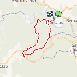
![](/images/other/stat-length.png)
![Randonnée Marche Montclus - MONTCLUS - 12.3 Km - 04h00 Heures - Dénivelé 368 m - Photo](https://media.geolcdn.com/t/1900/400/ext.pjpeg?maxdim=2&url=https%3A%2F%2Fstatic1.geolcdn.com%2Fsiteimages%2Fupload%2Ffiles%2F1553511878bg_sport_marche.png)
MONTCLUS - 12.3 Km - 04h00 Heures - Dénivelé 368 m
dansmabulle
Utilisateur
![Longueur](/images/other/stat-length.png)
![Altitude max](https://static1.geolcdn.com/siteimages/upload/files/1508320355ic_sort_altitude_max_24dp.png)
![Dénivelé positif](https://static1.geolcdn.com/siteimages/upload/files/1508320355ic_sort_den_pos_24dp.png)
![Km-Effort](/images/other/stat-length.png)
![Altitude min](https://static1.geolcdn.com/siteimages/upload/files/1508320355ic_sort_altitude_min_24dp.png)
![Dénivelé négatif](https://static1.geolcdn.com/siteimages/upload/files/1508320355ic_sort_den_neg_24dp.png)
![Boucle](https://static1.geolcdn.com/siteimages/upload/files/16400158638029165_repeat_loop_refresh_sync_direction_icon.png)
![Marche](https://static1.geolcdn.com/sitytour/trail-icons/101.png)
3h33
Difficulté : Moyen
![Scannez ce code QR pour ouvrir la randonnée dans l'application SityTrail](https://capi.geolives.com/qq0zvz2zws4bq2lad0pu/sitytour/trails/244603/qr.png?size=200)
Application GPS de randonnée GRATUITE
À propos
Randonnée Marche de 12,3 km à découvrir à Occitanie, Gard, Montclus. Cette randonnée est proposée par dansmabulle.
Description
12.3 Km - 04:00 Heures - Dénivelé 368 mètres
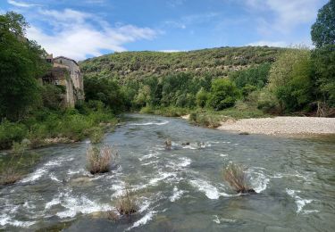
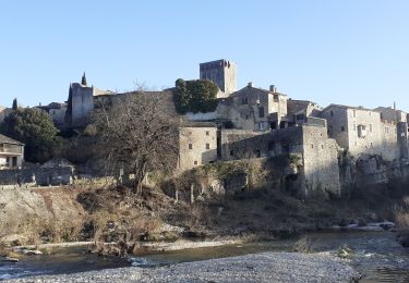
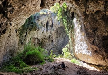
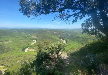
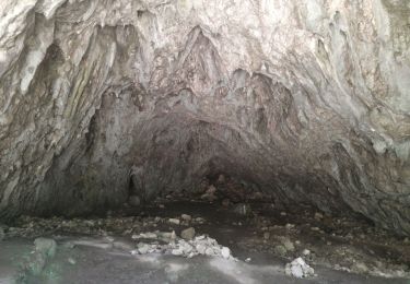
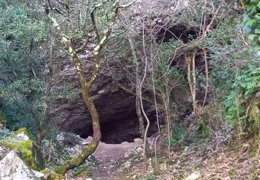
Départ randonnée : Village de Montclus -Gard 30- départ de Montclus pour une balade de 12,5Km dans la garrigue au nord du village. 330m de dénivelé cumulé, vue imprenable sur la CEZE depuis la dent du Serret, la balade se termine par la visite du village de MONTCLUS. Attention aux crues de la rivière -pont submersible-
Bonne randonnée
Localisation
Commentaires
Randonnées à proximité
![Randonnée Marche Saint-André-de-Roquepertuis - Montclus - St André de Roquepertuis - Photo](https://media.geolcdn.com/t/375/260/ext.jpg?maxdim=2&url=https%3A%2F%2Fservices.sitytrail.com%2FGeolivesWS%2FDownloadMedia.ashx%3FTrailID%3D317457%26Media%3D16689_6.jpg)
![Marche Marche](https://static1.geolcdn.com/sitytour/trail-icons/101.png)
Marche
![](/images/other/stat-length.png)
![](https://static1.geolcdn.com/siteimages/upload/files/16400158638029165_repeat_loop_refresh_sync_direction_icon.png)
![Randonnée Marche Le Garn - le garn - Photo](https://media.geolcdn.com/t/375/260/ext.jpg?maxdim=2&url=https%3A%2F%2Fstatic1.geolcdn.com%2Fsiteimages%2Fupload%2Ffiles%2F1553511878bg_sport_marche.png)
![Marche Marche](https://static1.geolcdn.com/sitytour/trail-icons/101.png)
![Randonnée Marche Montclus - Montclus - Photo](https://media.geolcdn.com/t/375/260/5b5dca1f-e2f4-40c9-83d1-740385f65a5b.jpg&format=jpg&maxdim=2)
![Marche Marche](https://static1.geolcdn.com/sitytour/trail-icons/101.png)
![Randonnée Marche Montclus - montclus - Photo](https://media.geolcdn.com/t/375/260/fc92434c-2f04-4c3b-985b-744df58331b6.jpg&format=jpg&maxdim=2)
![Marche Marche](https://static1.geolcdn.com/sitytour/trail-icons/101.png)
![Randonnée Marche Méjannes-le-Clap - grotte Aven de Peyre haute - Photo](https://media.geolcdn.com/t/375/260/d4f3ec17-14e0-4af7-b0c9-c2d485c47a84.jpg&format=jpg&maxdim=2)
![Marche Marche](https://static1.geolcdn.com/sitytour/trail-icons/101.png)
Marche
![](/images/other/stat-length.png)
![](https://static1.geolcdn.com/siteimages/upload/files/16400158638029165_repeat_loop_refresh_sync_direction_icon.png)
![Randonnée Marche Montclus - Montclus petite boucle. - Photo](https://media.geolcdn.com/t/375/260/ca2cf1e7-c5ab-4b22-8db8-d66d12e30ad1.jpg&format=jpg&maxdim=2)
![Marche Marche](https://static1.geolcdn.com/sitytour/trail-icons/101.png)
Marche
![](/images/other/stat-length.png)
![](https://static1.geolcdn.com/siteimages/upload/files/16400158638029165_repeat_loop_refresh_sync_direction_icon.png)
![Randonnée Marche Le Garn - Gorges de l'Ardèche - Photo](https://media.geolcdn.com/t/375/260/7be31073-c158-4c50-8635-f22156f6e6e3.jpg&format=jpg&maxdim=2)
![Marche Marche](https://static1.geolcdn.com/sitytour/trail-icons/101.png)
Marche
![](/images/other/stat-length.png)
![](https://static1.geolcdn.com/siteimages/upload/files/16400158638029165_repeat_loop_refresh_sync_direction_icon.png)
![Randonnée Marche Montclus - montclus le dent de serret - Photo](https://media.geolcdn.com/t/375/260/502269d4-8fd8-4096-b168-1f460ee74a78.jpg&format=jpg&maxdim=2)
![Marche Marche](https://static1.geolcdn.com/sitytour/trail-icons/101.png)
Marche
![](/images/other/stat-length.png)
![](https://static1.geolcdn.com/siteimages/upload/files/16400158638029165_repeat_loop_refresh_sync_direction_icon.png)
![Randonnée Marche Méjannes-le-Clap - Dent du Serret - Photo](https://media.geolcdn.com/t/375/260/8a2c0cb8-6baf-4e6f-bafb-7cfe6f13f7f8.jpg&format=jpg&maxdim=2)
![Marche Marche](https://static1.geolcdn.com/sitytour/trail-icons/101.png)
Marche
![](/images/other/stat-length.png)
![](https://static1.geolcdn.com/siteimages/upload/files/16400158638029165_repeat_loop_refresh_sync_direction_icon.png)