![](/images/other/stat-length.png)
![Randonnée Marche Aydius - Lac de Montagnon et pic Montagnon d'Iseye - Photo](https://media.geolcdn.com/t/1900/400/79e30076-f68a-4aa9-8c3c-46b60b0ada56.jpg&format=pjpeg&maxdim=2)
Lac de Montagnon et pic Montagnon d'Iseye
bedous
Utilisateur
![Longueur](/images/other/stat-length.png)
![Altitude max](https://static1.geolcdn.com/siteimages/upload/files/1508320355ic_sort_altitude_max_24dp.png)
![Dénivelé positif](https://static1.geolcdn.com/siteimages/upload/files/1508320355ic_sort_den_pos_24dp.png)
![Km-Effort](/images/other/stat-length.png)
![Altitude min](https://static1.geolcdn.com/siteimages/upload/files/1508320355ic_sort_altitude_min_24dp.png)
![Dénivelé négatif](https://static1.geolcdn.com/siteimages/upload/files/1508320355ic_sort_den_neg_24dp.png)
![Boucle](https://static1.geolcdn.com/siteimages/upload/files/16400158638029165_repeat_loop_refresh_sync_direction_icon.png)
![Marche](https://static1.geolcdn.com/sitytour/trail-icons/101.png)
6h40
Difficulté : Difficile
![Scannez ce code QR pour ouvrir la randonnée dans l'application SityTrail](https://capi.geolives.com/qq0zvz2zws4bq2lad0pu/sitytour/trails/2444823/qr.png?size=200)
Application GPS de randonnée GRATUITE
À propos
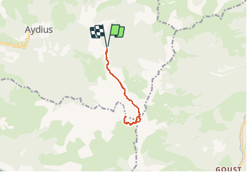
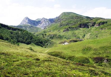
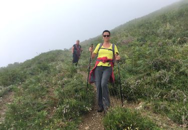
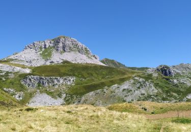
Randonnée Marche de 10,8 km à découvrir à Nouvelle-Aquitaine, Pyrénées-Atlantiques, Aydius. Cette randonnée est proposée par bedous.
Description
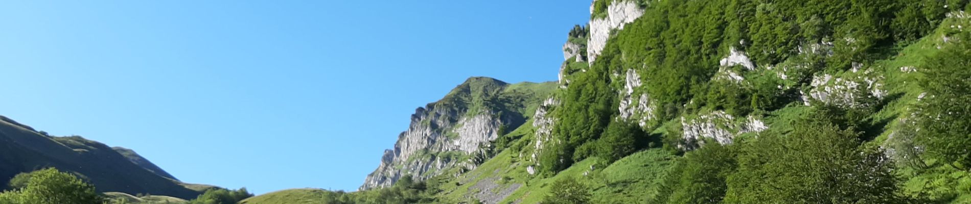
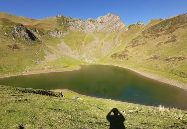
En vallée d'Aspe, du village d'Aydius suivre la piste d'accès ( très tôt le matin pour autorisation d'accès au plus près). La première heure de montée se déroule sous bois et est trés pentue ! Puis une longue rando qui monte au travers de paturages. L'accès au lac se termine par un sentier raide dans un pierré. Beaucoup d'effort pour un lieu magnifique. Un dernier effort pour atteindre le pic car vous aurez toujours envie d'y retourner pour les vues........
Localisation
Commentaires
Randonnées à proximité
![Randonnée Marche Bielle - Pics de Cambeilh et petit Gerbe - Photo](https://media.geolcdn.com/t/375/260/ext.jpg?maxdim=2&url=https%3A%2F%2Fservices.sitytrail.com%2FGeolivesWS%2FDownloadMedia.ashx%3FTrailID%3D521181%26Media%3Dfix__20160202151847.jpg)
![Marche Marche](https://static1.geolcdn.com/sitytour/trail-icons/101.png)
Marche
![](/images/other/stat-length.png)
![](https://static1.geolcdn.com/siteimages/upload/files/16400158638029165_repeat_loop_refresh_sync_direction_icon.png)
![Randonnée A pied Aydius - Tour du Mailh Massibé par Bésur asp100 - Photo](https://media.geolcdn.com/t/375/260/63a6bafa-5459-4dce-bf36-a3e4ba983890.jpeg&format=jpg&maxdim=2)
![A pied A pied](https://static1.geolcdn.com/sitytour/trail-icons/100.png)
A pied
![](/images/other/stat-length.png)
![](https://static1.geolcdn.com/siteimages/upload/files/16400158638029165_repeat_loop_refresh_sync_direction_icon.png)
![Randonnée A pied Aydius - Chemin des Buis de Camploung asp22 - Photo](https://media.geolcdn.com/t/375/260/63a6bafa-5459-4dce-bf36-a3e4ba983890.jpeg&format=jpg&maxdim=2)
![A pied A pied](https://static1.geolcdn.com/sitytour/trail-icons/100.png)
A pied
![](/images/other/stat-length.png)
![](https://static1.geolcdn.com/siteimages/upload/files/16400158638029165_repeat_loop_refresh_sync_direction_icon.png)
![Randonnée A pied Aydius - Col de Bergout par les Ichantes asp23 - Photo](https://media.geolcdn.com/t/375/260/63a6bafa-5459-4dce-bf36-a3e4ba983890.jpeg&format=jpg&maxdim=2)
![A pied A pied](https://static1.geolcdn.com/sitytour/trail-icons/100.png)
A pied
![](/images/other/stat-length.png)
![](https://static1.geolcdn.com/siteimages/upload/files/16400158638029165_repeat_loop_refresh_sync_direction_icon.png)
![Randonnée Marche Aydius - lac de montagnon - Photo](https://media.geolcdn.com/t/375/260/5ed19e71-65a9-444b-82ea-9100b101a800.jpg&format=jpg&maxdim=2)
![Marche Marche](https://static1.geolcdn.com/sitytour/trail-icons/101.png)
Marche
![](/images/other/stat-length.png)
![](https://static1.geolcdn.com/siteimages/upload/files/16400158638029165_repeat_loop_refresh_sync_direction_icon.png)
![Randonnée A pied Aydius - du Barca à la Cabane d'Arriutort asp106 - Photo](https://media.geolcdn.com/t/375/260/df582091-8896-406d-a764-75869922f6a5.jpeg&format=jpg&maxdim=2)
![A pied A pied](https://static1.geolcdn.com/sitytour/trail-icons/100.png)
A pied
![](/images/other/stat-length.png)
![](https://static1.geolcdn.com/siteimages/upload/files/16400158638029165_repeat_loop_refresh_sync_direction_icon.png)
![Randonnée Marche Aydius - Tour_Igaut-Chechit - Photo](https://media.geolcdn.com/t/375/260/4dff1440-f8d2-42a9-984d-2668c1d2f04d.jpg&format=jpg&maxdim=2)
![Marche Marche](https://static1.geolcdn.com/sitytour/trail-icons/101.png)
Marche
![](/images/other/stat-length.png)
![](https://static1.geolcdn.com/siteimages/upload/files/16400158638029165_repeat_loop_refresh_sync_direction_icon.png)
![Randonnée Marche Accous - Cabane du Bergout - Photo](https://media.geolcdn.com/t/375/260/d517029d-cf6a-4526-aeb7-ac8002b292f1.jpg&format=jpg&maxdim=2)
![Marche Marche](https://static1.geolcdn.com/sitytour/trail-icons/101.png)
Marche
![](/images/other/stat-length.png)
![](https://static1.geolcdn.com/siteimages/upload/files/16400158638029165_repeat_loop_refresh_sync_direction_icon.png)
![Randonnée Marche Aydius - pic mailh massibe et pic montagnon - Photo](https://media.geolcdn.com/t/375/260/12402e24-34c8-4e69-b3a6-ad60fc7c5ccb.jpg&format=jpg&maxdim=2)
![Marche Marche](https://static1.geolcdn.com/sitytour/trail-icons/101.png)
Marche
![](/images/other/stat-length.png)
![](https://static1.geolcdn.com/siteimages/upload/files/16400158638029165_repeat_loop_refresh_sync_direction_icon.png)