


6,8 km | 8,6 km-effort


Utilisateur


Application GPS de randonnée GRATUITE
 SityTrail
IGN / Instituts géographiques
SityTrail World
Le monde est à vous
Randonnée Marche de 9,6 km à découvrir à Occitanie, Gard, Saint-Hilaire-d'Ozilhan. Cette randonnée est proposée par dansmabulle.
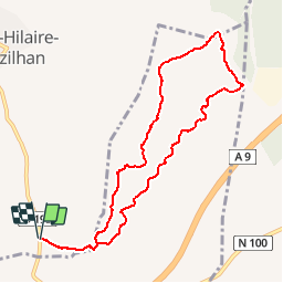
GRAND COMBE - ST HILAIRE D OZILHAN
9.7Km - 03:00
Départ randonnée : Garer la voiture au mieux dans les chemin vicinaux afin de na pas gêner les agriculteurs (Gard 30) 30210 carte IGN serie bleu 2941 Est Remoulins.Rando inattendue dans une gorge étroite et "labiryntique.Un instant de solitude.Cette rando peu faire suite à une autre déjà publiée sur ce site.Depuis le point de départ, partir vers l'Est sur un bon chemin et rejoindre la gorge qui ce devine à peine.Le sentier est bien tracé mais attention aux faux départs à droite ou à gauche (GPS utile) rester au fond de la gorge et déboucher sur le plateau.(l'autoroute n'est pas loin) rencontrer le GR63 que l'on prend à gauche et le quitter 900m plus loin par la gauche.La vue offre une vue d'ensemble des vignobles de St Hilaire et la voiture est proche.

Marche

Marche

Marche

Marche
Marche
Marche
Marche
Marche
Marche