![](/images/other/stat-length.png)
![Randonnée A pied Burg-Reuland - Burg-Reuland - Balade 29 - Guide de l'Ardenne du Nord - Photo](https://media.geolcdn.com/t/1900/400/ext.pjpeg?maxdim=2&url=https%3A%2F%2Fstatic1.geolcdn.com%2Fsiteimages%2Fupload%2Ffiles%2F1545311037marcheuse_200dpi.jpg)
Burg-Reuland - Balade 29 - Guide de l'Ardenne du Nord
AnneCecile
Utilisateur
![Longueur](/images/other/stat-length.png)
Longueur
11,2 km
![Altitude max](https://static1.geolcdn.com/siteimages/upload/files/1508320355ic_sort_altitude_max_24dp.png)
Altitude max
495 m
![Dénivelé positif](https://static1.geolcdn.com/siteimages/upload/files/1508320355ic_sort_den_pos_24dp.png)
Dénivelé positif
245 m
![Km-Effort](/images/other/stat-length.png)
Km-Effort
14,5 km
![Altitude min](https://static1.geolcdn.com/siteimages/upload/files/1508320355ic_sort_altitude_min_24dp.png)
Altitude min
350 m
![Dénivelé négatif](https://static1.geolcdn.com/siteimages/upload/files/1508320355ic_sort_den_neg_24dp.png)
Dénivelé négatif
245 m
![Boucle](https://static1.geolcdn.com/siteimages/upload/files/16400158638029165_repeat_loop_refresh_sync_direction_icon.png)
Boucle
Oui
Date de création :
2020-06-20 20:33:36.918
Dernière modification :
2020-06-20 20:49:32.531
![A pied](https://static1.geolcdn.com/sitytour/trail-icons/100.png)
--
Difficulté : Très facile
![Scannez ce code QR pour ouvrir la randonnée dans l'application SityTrail](https://capi.geolives.com/qq0zvz2zws4bq2lad0pu/sitytour/trails/2443911/qr.png?size=200)
Application GPS de randonnée GRATUITE
À propos
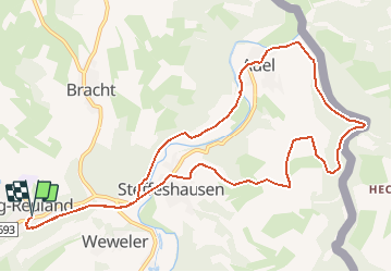
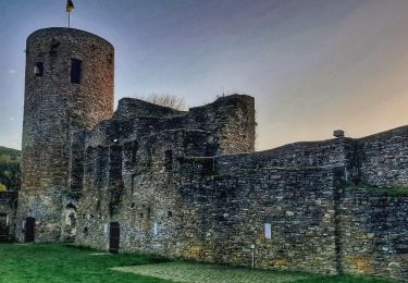
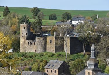
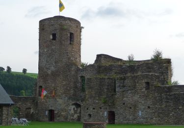
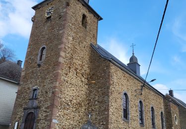
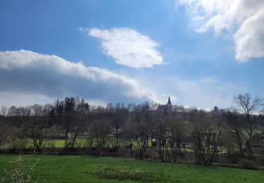
Randonnée A pied de 11,2 km à découvrir à Wallonie, Liège, Burg-Reuland. Cette randonnée est proposée par AnneCecile.
Description
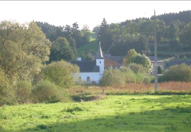
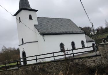
Situation: Burg-Reuland
Parking : à l'entrée du village sur la droite
Balisage : rectangle jaune
Départ : dans le centre de Burg-Reuland suivez les panneau Ravel
Localisation
Pays :
Belgique
Région :
Wallonie
Département/Province :
Liège
Commune :
Burg-Reuland
Localité :
Reuland
Départ:(Dec)
Départ:(UTM)
295600 ; 5564311 (32U) N.
Commentaires
Randonnées à proximité
![Randonnée Marche Saint-Vith - RB-Lg-08_Lommersweiler_via-racc - Photo](https://media.geolcdn.com/t/375/260/ext.jpg?maxdim=2&url=https%3A%2F%2Fservices.sitytrail.com%2FGeolivesWS%2FDownloadMedia.ashx%3FTrailID%3D209419%26Media%3D8658b813-efb8-4716-8028-e5a806af61f9.jpg)
![Marche Marche](https://static1.geolcdn.com/sitytour/trail-icons/101.png)
RB-Lg-08_Lommersweiler_via-racc
Marche
Très difficile
(2)
Saint-Vith,
Wallonie,
Liège,
Belgique
![](/images/other/stat-length.png)
16,3 km | 22 km-effort
4h 55min
![](https://static1.geolcdn.com/siteimages/upload/files/16400158638029165_repeat_loop_refresh_sync_direction_icon.png)
Oui
![Randonnée Marche Saint-Vith - RB-Lg-08_Lommersweiler - Photo](https://media.geolcdn.com/t/375/260/ext.jpg?maxdim=2&url=https%3A%2F%2Fservices.sitytrail.com%2FGeolivesWS%2FDownloadMedia.ashx%3FTrailID%3D179566%26Media%3D34b93d32-cd75-4b58-b84c-dd7aa7c61885.jpg)
![Marche Marche](https://static1.geolcdn.com/sitytour/trail-icons/101.png)
RB-Lg-08_Lommersweiler
Marche
Très difficile
(3)
Saint-Vith,
Wallonie,
Liège,
Belgique
![](/images/other/stat-length.png)
21 km | 28 km-effort
6h 18min
![](https://static1.geolcdn.com/siteimages/upload/files/16400158638029165_repeat_loop_refresh_sync_direction_icon.png)
Oui
![Randonnée Marche Burg-Reuland - Grufflngen - Photo](https://media.geolcdn.com/t/375/260/10cbd4be-8c1f-4424-9db5-3cea24db22bb.jpg&format=jpg&maxdim=2)
![Marche Marche](https://static1.geolcdn.com/sitytour/trail-icons/101.png)
Grufflngen
Marche
Très facile
(1)
Burg-Reuland,
Wallonie,
Liège,
Belgique
![](/images/other/stat-length.png)
10 km | 13,2 km-effort
4h 25min
![](https://static1.geolcdn.com/siteimages/upload/files/16400158638029165_repeat_loop_refresh_sync_direction_icon.png)
Oui
![Randonnée Marche Burg-Reuland - Balade à Burg-Reuland - Photo](https://media.geolcdn.com/t/375/260/4a1fc727-7ca9-43e9-9048-777c0d3a2d5c.jpeg&format=jpg&maxdim=2)
![Marche Marche](https://static1.geolcdn.com/sitytour/trail-icons/101.png)
Balade à Burg-Reuland
Marche
Difficile
Burg-Reuland,
Wallonie,
Liège,
Belgique
![](/images/other/stat-length.png)
13,4 km | 17,2 km-effort
6h 40min
![](https://static1.geolcdn.com/siteimages/upload/files/16400158638029165_repeat_loop_refresh_sync_direction_icon.png)
Oui
![Marche Marche](https://static1.geolcdn.com/sitytour/trail-icons/101.png)
20221027 - TOTEMUS Burg-Reuland - 5.2 Km
Marche
Moyen
Burg-Reuland,
Wallonie,
Liège,
Belgique
![](/images/other/stat-length.png)
5,2 km | 7,2 km-effort
2h 52min
![](https://static1.geolcdn.com/siteimages/upload/files/16400158638029165_repeat_loop_refresh_sync_direction_icon.png)
Oui
![A pied A pied](https://static1.geolcdn.com/sitytour/trail-icons/100.png)
GrWandArd 26: Burg-Reuland panorama's van de Thommerberg (PVDB)
A pied
Facile
Burg-Reuland,
Wallonie,
Liège,
Belgique
![](/images/other/stat-length.png)
6,5 km | 9 km-effort
2h 2min
![](https://static1.geolcdn.com/siteimages/upload/files/16400158638029165_repeat_loop_refresh_sync_direction_icon.png)
Oui
![Randonnée Marche Burg-Reuland - Burg Reuland 180423 - Photo](https://media.geolcdn.com/t/375/260/3c36ae65-aa52-40a7-a98c-9e9f1b9442b7.jpg&format=jpg&maxdim=2)
![Marche Marche](https://static1.geolcdn.com/sitytour/trail-icons/101.png)
Burg Reuland 180423
Marche
Difficile
Burg-Reuland,
Wallonie,
Liège,
Belgique
![](/images/other/stat-length.png)
144 km | 176 km-effort
5h 19min
![](https://static1.geolcdn.com/siteimages/upload/files/16400158638029165_repeat_loop_refresh_sync_direction_icon.png)
Non
![Randonnée Marche Burg-Reuland - rando burg reuland 18-04-2023 - Photo](https://media.geolcdn.com/t/375/260/0fdf5f0f-107a-404c-aa26-b0989bd639a9.jpg&format=jpg&maxdim=2)
![Marche Marche](https://static1.geolcdn.com/sitytour/trail-icons/101.png)
rando burg reuland 18-04-2023
Marche
Difficile
Burg-Reuland,
Wallonie,
Liège,
Belgique
![](/images/other/stat-length.png)
18,8 km | 26 km-effort
4h 29min
![](https://static1.geolcdn.com/siteimages/upload/files/16400158638029165_repeat_loop_refresh_sync_direction_icon.png)
Oui
![Randonnée Marche Saint-Vith - Burgknof circuit - Photo](https://media.geolcdn.com/t/375/260/5a026696-2e2c-4f0f-9029-84aee82d1ade.jpg&format=jpg&maxdim=2)
![Marche Marche](https://static1.geolcdn.com/sitytour/trail-icons/101.png)
Burgknof circuit
Marche
Facile
Saint-Vith,
Wallonie,
Liège,
Belgique
![](/images/other/stat-length.png)
16,1 km | 21 km-effort
3h 23min
![](https://static1.geolcdn.com/siteimages/upload/files/16400158638029165_repeat_loop_refresh_sync_direction_icon.png)
Oui