Randonnée Vélo de route Cabestany - Cab-Amelie-Llaurom - Photo
 Michel Pontie
Michel Pontie

Utilisateur

© OpenStreetMap contributors
Longueur
Longueur
100 km
Altitude max
Altitude max
392 m
Dénivelé positif
Dénivelé positif
1130 m
Km-Effort
Km-Effort  
115 km
Altitude min
Altitude min
5 m
Dénivelé négatif
Dénivelé négatif
1129 m
Boucle
Boucle
Oui
Date de création :
2020-06-20 05:18:07.166
Dernière modification :
2020-06-20 14:52:04.585

(0 Avis)

Vélo de route
Vélo de route
5h03
Difficulté : Moyen

Scannez ce code QR pour ouvrir la randonnée dans l'application SityTrail

Application GPS de randonnée GRATUITE

Logo SityTrail SityTrail

IGN / Instituts géographiques

Télécharger SityTrail sur l'App Store Télécharger SityTrail sur Google Play

Logo SityTrail SityTrail World

Le monde est à vous

Télécharger SityTrail sur l'App Store Télécharger SityTrail sur Google Play Télécharger SityTrail sur Huawei AppGallery

À propos

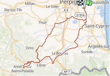
Randonnée Vélo de route de 100 km à découvrir à Occitanie, Pyrénées-Orientales, Cabestany. Cette randonnée est proposée par Michel Pontie.

Description

cab théza montescot brouilla st gen maureillas sr jean ceret amelie Palalda le vila  céret llauro fourques trouillas ponteilla nyls pollestres villeneuve théza

Profil altimétrique

Localisation

Pays :
France
Région :
Occitanie
Département/Province :
Pyrénées-Orientales
Commune :
Cabestany
Localité :
Unknown
Départ:(UTM)
495605 ; 4724408 (31T) N.

Randonnées à proximité

Randonnée Marche Théza - 66 THEZA - CORNEILLA-DEL-VERCOL - Photo
Marche
jeff66

Marche

Facile
(2)
Théza, Occitanie, Pyrénées-Orientales, France
7 km | 7,5 km-effort
1h 8min
Oui
Randonnée Marche Cabestany - Chemins autour de Cabestany - Photo
Marche
tracegps

Marche

Moyen
(2)
Cabestany, Occitanie, Pyrénées-Orientales, France
11,8 km | 12,7 km-effort
3h 0min
Oui
Randonnée Marche Perpignan - Perpignan 01.10.2017  - Photo
Marche
jeff66

Marche

Facile
(1)
Perpignan, Occitanie, Pyrénées-Orientales, France
6,7 km | 7,5 km-effort
1h 39min
Non
Randonnée Marche Villeneuve-de-la-Raho - 66 VILLENEUVE-DE-LA-RAHO - grand tour périphérique du lac par les lignes de crêtes  - Photo
Marche
jeff66

Marche

Facile
(2)
Villeneuve-de-la-Raho, Occitanie, Pyrénées-Orientales, France
10 km | 11,5 km-effort
1h 44min
Oui
Randonnée Marche Saleilles - 66 SALEILLES - St-NAZAIRE, entre FOSSEILLE et REART - Photo
Marche
jeff66

Marche

Facile
(1)
Saleilles, Occitanie, Pyrénées-Orientales, France
7,3 km | 7,7 km-effort
1h 8min
Oui
Randonnée Quad Villeneuve-de-la-Raho - Villeneuve-de-la-Raho-Collioure(Juillet-Aout) - Photo
Quad
Quad Ride

Quad

Très facile
(1)
Villeneuve-de-la-Raho, Occitanie, Pyrénées-Orientales, France
39 km | 44 km-effort
1h 40min
Non
Randonnée Marche Cabestany - cabestany - Photo
Marche
66Gribouille83

Marche

Moyen
Cabestany, Occitanie, Pyrénées-Orientales, France
7,5 km | 8,2 km-effort
2h 35min
Oui
Randonnée Marche Perpignan - petit tour à Perpignan  - Photo
Marche
GUIDE
stef789

Marche

Très facile
Perpignan, Occitanie, Pyrénées-Orientales, France
3,9 km | 4,2 km-effort
1h 53min
Oui
Randonnée Marche Perpignan - Perpignan  - Photo
Marche
ombrabella

Marche

Très facile
Perpignan, Occitanie, Pyrénées-Orientales, France
18 km | 19,9 km-effort
2h 23min
Non


Fermer
Mes abonnements