![](/images/other/stat-length.png)
![Randonnée Vélo de route Château-sur-Allier - Véloroute 70 Allier- Puy de Dôme - Photo](https://media.geolcdn.com/t/1900/400/ext.pjpeg?maxdim=2&url=https%3A%2F%2Fstatic1.geolcdn.com%2Fsiteimages%2Fupload%2Ffiles%2F1524743154velo.jpg)
Véloroute 70 Allier- Puy de Dôme
guillaumepdm
Utilisateur
![Longueur](/images/other/stat-length.png)
![Boucle](https://static1.geolcdn.com/siteimages/upload/files/16400158638029165_repeat_loop_refresh_sync_direction_icon.png)
![Vélo de route](https://static1.geolcdn.com/sitytour/trail-icons/201.png)
5h00
Difficulté : Difficile
![Scannez ce code QR pour ouvrir la randonnée dans l'application SityTrail](https://capi.geolives.com/qq0zvz2zws4bq2lad0pu/sitytour/trails/2440906/qr.png?size=200)
Application GPS de randonnée GRATUITE
À propos
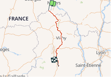
Randonnée Vélo de route de 244 km à découvrir à Auvergne-Rhône-Alpes, Allier, Château-sur-Allier. Cette randonnée est proposée par guillaumepdm.
Description
La VÉLOROUTE 70 parcourt le département Allier du nord au sud sur 141 km, autour du val d’Allier.
C’est l’une des rares portions balisées du grand itinéraire reliant l’Eurovélo 6 (au sud de Nevers) à la Méditerranée.
La "Véloroute 70", achevée en 2016, se connecte à Moulins à la « Véloroute 75 » qui dessert, à l'est, l'EV6 / "EuroVelo-route de l’Atlantique à la mer Noire" et "la Loire à Vélo" et qui rejoint, à l'ouest, la voie verte du canal du Berry (V46a) et la V87 à partir de Montluçon.
Localisation
Commentaires
Randonnées à proximité
![Randonnée Course à pied Sancoins - sancoins janvier 2019 - Photo](https://media.geolcdn.com/t/375/260/ext.jpg?maxdim=2&url=https%3A%2F%2Fservices.sitytrail.com%2FGeolivesWS%2FDownloadMedia.ashx%3FTrailID%3D1096257%26Media%3Dfix__20190113104415.jpg)
![Course à pied Course à pied](https://static1.geolcdn.com/sitytour/trail-icons/103.png)
Course à pied
![](/images/other/stat-length.png)
![](https://static1.geolcdn.com/siteimages/upload/files/16400158638029165_repeat_loop_refresh_sync_direction_icon.png)
![Randonnée Marche Sancoins - Sancoins. Charenton du Cher - Photo](https://media.geolcdn.com/t/375/260/ext.jpg?maxdim=2&url=https%3A%2F%2Fstatic1.geolcdn.com%2Fsiteimages%2Fupload%2Ffiles%2F1553511878bg_sport_marche.png)
![Marche Marche](https://static1.geolcdn.com/sitytour/trail-icons/101.png)
Marche
![](/images/other/stat-length.png)
![](https://static1.geolcdn.com/siteimages/upload/files/16400158638029165_repeat_loop_refresh_sync_direction_icon.png)
![Randonnée Marche Sancoins - GR300 Randonnée de Sancoins (Cher) au Puy-en-Velay (Haute-Loire) - Photo](https://media.geolcdn.com/t/375/260/ext.jpg?maxdim=2&url=https%3A%2F%2Fstatic1.geolcdn.com%2Fsiteimages%2Fupload%2Ffiles%2F1553511878bg_sport_marche.png)
![Marche Marche](https://static1.geolcdn.com/sitytour/trail-icons/101.png)
Marche
![](/images/other/stat-length.png)
![](https://static1.geolcdn.com/siteimages/upload/files/16400158638029165_repeat_loop_refresh_sync_direction_icon.png)
![Randonnée Course à pied Sancoins - sanctions Téléthon - Photo](https://media.geolcdn.com/t/375/260/ext.jpg?maxdim=2&url=https%3A%2F%2Fstatic1.geolcdn.com%2Fsiteimages%2Fupload%2Ffiles%2F1524743154running.jpg)
![Course à pied Course à pied](https://static1.geolcdn.com/sitytour/trail-icons/103.png)
Course à pied
![](/images/other/stat-length.png)
![](https://static1.geolcdn.com/siteimages/upload/files/16400158638029165_repeat_loop_refresh_sync_direction_icon.png)