![](/images/other/stat-length.png)
![Randonnée V.T.T. Saint-Paul-Trois-Châteaux - Circuit Vert n°2 - Les Faubourgs de St Paul - Photo](https://media.geolcdn.com/t/1900/400/c6ed598f-bd2f-4c00-96ca-a243b1144f9c.png&format=pjpeg&maxdim=2)
Circuit Vert n°2 - Les Faubourgs de St Paul
lespoulpes
Utilisateur
![Longueur](/images/other/stat-length.png)
![Altitude max](https://static1.geolcdn.com/siteimages/upload/files/1508320355ic_sort_altitude_max_24dp.png)
![Dénivelé positif](https://static1.geolcdn.com/siteimages/upload/files/1508320355ic_sort_den_pos_24dp.png)
![Km-Effort](/images/other/stat-length.png)
![Altitude min](https://static1.geolcdn.com/siteimages/upload/files/1508320355ic_sort_altitude_min_24dp.png)
![Dénivelé négatif](https://static1.geolcdn.com/siteimages/upload/files/1508320355ic_sort_den_neg_24dp.png)
![Boucle](https://static1.geolcdn.com/siteimages/upload/files/16400158638029165_repeat_loop_refresh_sync_direction_icon.png)
![V.T.T.](https://static1.geolcdn.com/sitytour/trail-icons/202.png)
1h00
Difficulté : Facile
![Scannez ce code QR pour ouvrir la randonnée dans l'application SityTrail](https://capi.geolives.com/qq0zvz2zws4bq2lad0pu/sitytour/trails/2437617/qr.png?size=200)
Application GPS de randonnée GRATUITE
À propos
Randonnée V.T.T. de 13,3 km à découvrir à Auvergne-Rhône-Alpes, Drôme, Saint-Paul-Trois-Châteaux. Cette randonnée est proposée par lespoulpes.
Description
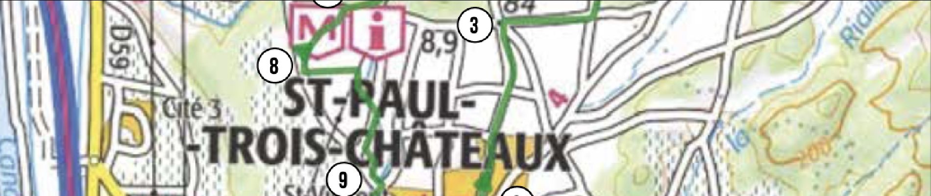
2 - TRÈS FACILE | 13,5 km | 110 m déniv. | 1h30 Départ : Saint-Paul-Trois-Châteaux
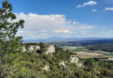
Sans grandes difficultés, ce circuit vous conduit au nord de Saint-Paul- Trois-Châteaux découvrir la plaine entre Saint-Paul, La Garde-Adhémar et la colline de Chanabasset avec ses paysages et ses senteurs de provence. Le retour s’effectue par la magnifique voie verte.
Parcours :
DÉPART : Place Chausy, devant l’office de Tourisme (point d’eau). Au poteau Saint-Paul Trois-Châteaux (alt. 90 m), tourner à droite, puis à gauche au prochain carrefour.
1. S'engager à droite dans une ruelle, suivre le balisage n°2, puis rejoindre une route et un rond point. Attention voitures !
0,2 km
2. Prendre la 3e sortie, puis continuer tout droit et passer devant un centre équestre.
0,6 km
3. Tourner sur la deuxième route à droite. Plus loin prendre à gauche. S'engager ensuite sur un chemin à gauche. Rejoindre une route et tourner à droite.
1,9 km
4. À un croisement, prendre à droite et continuer sur la plaine jusqu'à bifurquer à gauche sur un chemin carrossable.
4km
5. Arriver à une route, tourner à gauche puis de suite à droite. Continuer tout droit jusqu'à un gîte. Plus loin, à un pont, tourner à gauche.
6,4 km
6. Prendre à droite et plus loin s'engager sur un chemin à gauche, une montée parfois technique (pierres) et profiter du paysage méditéranéen.
8,7 km
7. Quitter la colline de Chanabasset en s'engageant en face sur une petite route. Rejoindre la D158 et tourner à gauche. Attention voitures !
10,1 km
8. Prendre à gauche un chemin à travers champs, puis rejoindre une petite route et tourner à droite.
10,6 km
9. Tourner à gauche dans le lotissement et atteindre une route. Attention voitures ! Tourner à gauche, puis plus loin à droite.
11,5 km
10. S'engager à gauche sur la pittoresque voie verte et atteindre le poteau Traverse de Piéjoux (alt. 83 m)
12,2 km
11. Continuer tout droit sur la voie verte et rejoindre, après une traversée de route, le chemin pris à l'aller.
12,8 km
ARRIVÉE : Place Chausy (point d’eau)
13,5 km
Localisation
Commentaires
Randonnées à proximité
![Randonnée Marche Clansayes - Clansayes Le Rouvergue 7km - Photo](https://media.geolcdn.com/t/375/260/de3feb6f-5587-4e87-a580-1261cf3df48e.jpg&format=jpg&maxdim=2)
![Marche Marche](https://static1.geolcdn.com/sitytour/trail-icons/101.png)
Marche
![](/images/other/stat-length.png)
![](https://static1.geolcdn.com/siteimages/upload/files/16400158638029165_repeat_loop_refresh_sync_direction_icon.png)
![Randonnée Marche Saint-Restitut - St Restitut Le Barry 12km - Photo](https://media.geolcdn.com/t/375/260/52d96bcf-650b-4fd0-a59a-69f2b2d3703d.jpg&format=jpg&maxdim=2)
![Marche Marche](https://static1.geolcdn.com/sitytour/trail-icons/101.png)
Marche
![](/images/other/stat-length.png)
![](https://static1.geolcdn.com/siteimages/upload/files/16400158638029165_repeat_loop_refresh_sync_direction_icon.png)
![Randonnée Marche Bollène - Barry Chabrières Enclume 7,5km - Photo](https://media.geolcdn.com/t/375/260/3a4e67d1-088f-449d-b525-af6a45f2f0d7.jpg&format=jpg&maxdim=2)
![Marche Marche](https://static1.geolcdn.com/sitytour/trail-icons/101.png)
Marche
![](/images/other/stat-length.png)
![](https://static1.geolcdn.com/siteimages/upload/files/16400158638029165_repeat_loop_refresh_sync_direction_icon.png)
![Randonnée Marche Saint-Restitut - St Restitut Barry 14km - Photo](https://media.geolcdn.com/t/375/260/919620e4-c2f5-475b-864c-8c28884f4028.jpg&format=jpg&maxdim=2)
![Marche Marche](https://static1.geolcdn.com/sitytour/trail-icons/101.png)
Marche
![](/images/other/stat-length.png)
![](https://static1.geolcdn.com/siteimages/upload/files/16400158638029165_repeat_loop_refresh_sync_direction_icon.png)
![Randonnée Marche Saint-Restitut - Les carrières de Sainte Juste - Saint Restitut - Photo](https://media.geolcdn.com/t/375/260/ext.jpg?maxdim=2&url=https%3A%2F%2Fservices.sitytrail.com%2FGeolivesWS%2FDownloadMedia.ashx%3FTrailID%3D317462%26Media%3D16693_6.jpg)
![Marche Marche](https://static1.geolcdn.com/sitytour/trail-icons/101.png)
Marche
![](/images/other/stat-length.png)
![](https://static1.geolcdn.com/siteimages/upload/files/16400158638029165_repeat_loop_refresh_sync_direction_icon.png)
![Randonnée Marche Suze-la-Rousse - soleirieu - Photo](https://media.geolcdn.com/t/375/260/ext.jpg?maxdim=2&url=https%3A%2F%2Fstatic1.geolcdn.com%2Fsiteimages%2Fupload%2Ffiles%2F1553511878bg_sport_marche.png)
![Marche Marche](https://static1.geolcdn.com/sitytour/trail-icons/101.png)
Marche
![](/images/other/stat-length.png)
![](https://static1.geolcdn.com/siteimages/upload/files/16400158638029165_repeat_loop_refresh_sync_direction_icon.png)
![Randonnée Marche Clansayes - Clansayes Le Rouvergue 11km - Photo](https://media.geolcdn.com/t/375/260/89c952dc-9c57-4311-93c9-63263f0349ef.jpg&format=jpg&maxdim=2)
![Marche Marche](https://static1.geolcdn.com/sitytour/trail-icons/101.png)
Marche
![](/images/other/stat-length.png)
![](https://static1.geolcdn.com/siteimages/upload/files/16400158638029165_repeat_loop_refresh_sync_direction_icon.png)
![Randonnée Marche Clansayes - Clansayes Le Rouvergue 8km. - Photo](https://media.geolcdn.com/t/375/260/00183d4b-7799-462e-b9b9-5e3d9f7cb776.jpg&format=jpg&maxdim=2)
![Marche Marche](https://static1.geolcdn.com/sitytour/trail-icons/101.png)
Marche
![](/images/other/stat-length.png)
![](https://static1.geolcdn.com/siteimages/upload/files/16400158638029165_repeat_loop_refresh_sync_direction_icon.png)
![Randonnée Marche Clansayes - Clansayes Le Rouvergue 12km - Photo](https://media.geolcdn.com/t/375/260/10944c4f-f60a-41d6-ab1f-e2a3431a6612.jpg&format=jpg&maxdim=2)
![Marche Marche](https://static1.geolcdn.com/sitytour/trail-icons/101.png)
Marche
![](/images/other/stat-length.png)
![](https://static1.geolcdn.com/siteimages/upload/files/16400158638029165_repeat_loop_refresh_sync_direction_icon.png)