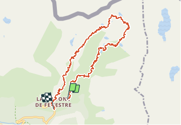
![](/images/other/stat-length.png)
![Randonnée Marche Saint-Martin-Vésubie - 200614 Lacs Balaour - Photo](https://media.geolcdn.com/t/1900/400/6c8cc98d-71f6-462c-8fea-8d46d7b04e2b.jpg&format=pjpeg&maxdim=2)
200614 Lacs Balaour
patsure
Utilisateur
![Longueur](/images/other/stat-length.png)
![Altitude max](https://static1.geolcdn.com/siteimages/upload/files/1508320355ic_sort_altitude_max_24dp.png)
![Dénivelé positif](https://static1.geolcdn.com/siteimages/upload/files/1508320355ic_sort_den_pos_24dp.png)
![Km-Effort](/images/other/stat-length.png)
![Altitude min](https://static1.geolcdn.com/siteimages/upload/files/1508320355ic_sort_altitude_min_24dp.png)
![Dénivelé négatif](https://static1.geolcdn.com/siteimages/upload/files/1508320355ic_sort_den_neg_24dp.png)
![Boucle](https://static1.geolcdn.com/siteimages/upload/files/16400158638029165_repeat_loop_refresh_sync_direction_icon.png)
![Marche](https://static1.geolcdn.com/sitytour/trail-icons/101.png)
4h00
Difficulté : Difficile
![Scannez ce code QR pour ouvrir la randonnée dans l'application SityTrail](https://capi.geolives.com/qq0zvz2zws4bq2lad0pu/sitytour/trails/2436591/qr.png?size=200)
Application GPS de randonnée GRATUITE
À propos
Randonnée Marche de 14 km à découvrir à Provence-Alpes-Côte d'Azur, Alpes-Maritimes, Saint-Martin-Vésubie. Cette randonnée est proposée par patsure.
Description
Très belle rando au départ de la vacherie de Fenestre qui sort des sentiers habituels donc avec moins de monde. Au pied du Gelas, de magnifique paysage qui donne une sensation de haute montagne.
Lacs Balaour - lac Cabret - lac Blanc - lac Mort.
En juin 2020 pas mal de neige au dessus du lac Cabret. Le lac Blanc était presque entièrement gelé.
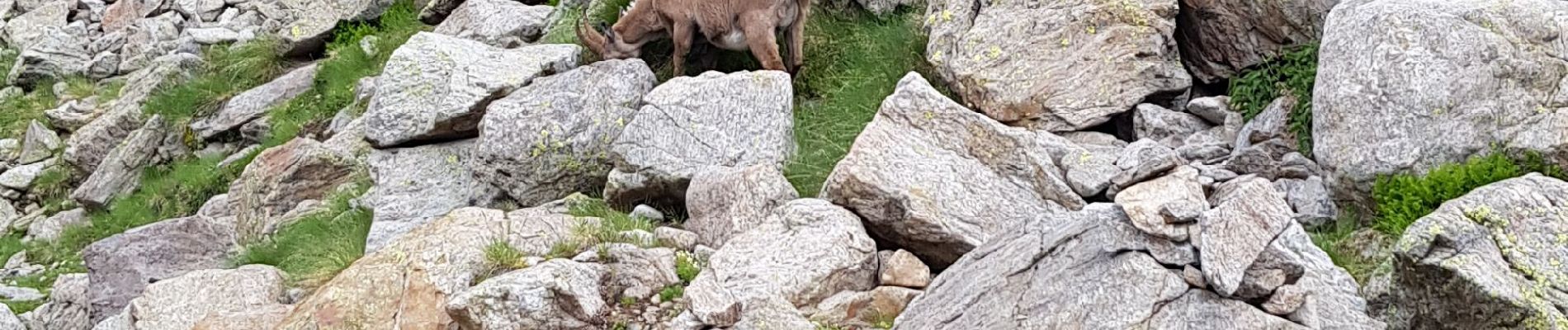
Le haut de la descente se fait dans les pierriers.
Localisation
Commentaires
Randonnées à proximité
![Randonnée Marche Saint-Martin-Vésubie - Lac de Trécolpas - Photo](https://media.geolcdn.com/t/375/260/ext.jpg?maxdim=2&url=https%3A%2F%2Fservices.sitytrail.com%2FGeolivesWS%2FDownloadMedia.ashx%3FTrailID%3D311062%26Media%3Dfix__20140607150849.jpg)
![Marche Marche](https://static1.geolcdn.com/sitytour/trail-icons/101.png)
Marche
![](/images/other/stat-length.png)
![](https://static1.geolcdn.com/siteimages/upload/files/16400158638029165_repeat_loop_refresh_sync_direction_icon.png)
![Randonnée A pied Saint-Martin-Vésubie - Lacs de Prals - Photo](https://media.geolcdn.com/t/375/260/ext.jpg?maxdim=2&url=https%3A%2F%2Fstatic1.geolcdn.com%2Fsiteimages%2Fupload%2Ffiles%2F1545311037marcheuse_200dpi.jpg)
![A pied A pied](https://static1.geolcdn.com/sitytour/trail-icons/100.png)
A pied
![](/images/other/stat-length.png)
![](https://static1.geolcdn.com/siteimages/upload/files/16400158638029165_repeat_loop_refresh_sync_direction_icon.png)
![Randonnée Marche Saint-Martin-Vésubie - lacs bessons - Photo](https://media.geolcdn.com/t/375/260/a0e4b44d-1510-4e32-82be-e7e2ee548788.jpg&format=jpg&maxdim=2)
![Marche Marche](https://static1.geolcdn.com/sitytour/trail-icons/101.png)
Marche
![](/images/other/stat-length.png)
![](https://static1.geolcdn.com/siteimages/upload/files/16400158638029165_repeat_loop_refresh_sync_direction_icon.png)
![Randonnée Marche Saint-Martin-Vésubie - Boucle Les lacs de Prals par la cime de la Vallette - Photo](https://media.geolcdn.com/t/375/260/2c298eac-1e8e-4f8d-83e4-c08337da9759.jpg&format=jpg&maxdim=2)
![Marche Marche](https://static1.geolcdn.com/sitytour/trail-icons/101.png)
Marche
![](/images/other/stat-length.png)
![](https://static1.geolcdn.com/siteimages/upload/files/16400158638029165_repeat_loop_refresh_sync_direction_icon.png)
![Randonnée Marche Saint-Martin-Vésubie - Lac Trecolpas - Pas des Ladres - Col de Fenestre - Refuge Cougourde - Photo](https://media.geolcdn.com/t/375/260/541e5768-e182-4791-be6f-0df4a21d2a23.jpg&format=jpg&maxdim=2)
![Marche Marche](https://static1.geolcdn.com/sitytour/trail-icons/101.png)
Marche
![](/images/other/stat-length.png)
![](https://static1.geolcdn.com/siteimages/upload/files/16400158638029165_repeat_loop_refresh_sync_direction_icon.png)
![Randonnée A pied Belvédère - Les Merveilles par la Gordolasque - Photo](https://media.geolcdn.com/t/375/260/530d04a7-b615-4962-acf5-9f79fcad8eda.jpeg&format=jpg&maxdim=2)
![A pied A pied](https://static1.geolcdn.com/sitytour/trail-icons/100.png)
A pied
![](/images/other/stat-length.png)
![](https://static1.geolcdn.com/siteimages/upload/files/16400158638029165_repeat_loop_refresh_sync_direction_icon.png)
![Randonnée A pied Saint-Martin-Vésubie - Circuit de Fenestre - Photo](https://media.geolcdn.com/t/375/260/2f55aaab-545e-409a-9c6e-8c2e9c42d8aa.jpeg&format=jpg&maxdim=2)
![A pied A pied](https://static1.geolcdn.com/sitytour/trail-icons/100.png)
A pied
![](/images/other/stat-length.png)
![](https://static1.geolcdn.com/siteimages/upload/files/16400158638029165_repeat_loop_refresh_sync_direction_icon.png)
![Randonnée A pied Saint-Martin-Vésubie - Circuit de Trécolpas - Photo](https://media.geolcdn.com/t/375/260/f92e70c7-1f9c-4fa6-ae6b-2c614b3b921c.jpeg&format=jpg&maxdim=2)
![A pied A pied](https://static1.geolcdn.com/sitytour/trail-icons/100.png)
A pied
![](/images/other/stat-length.png)
![](https://static1.geolcdn.com/siteimages/upload/files/16400158638029165_repeat_loop_refresh_sync_direction_icon.png)
![Marche Marche](https://static1.geolcdn.com/sitytour/trail-icons/101.png)
Marche
![](/images/other/stat-length.png)
![](https://static1.geolcdn.com/siteimages/upload/files/16400158638029165_repeat_loop_refresh_sync_direction_icon.png)