![](/images/other/stat-length.png)
![Randonnée Raquettes à neige Allevard - 2014 01 19 Crêt du poulet - Photo](https://media.geolcdn.com/t/1900/400/ext.pjpeg?maxdim=2&url=https%3A%2F%2Fstatic1.geolcdn.com%2Fsiteimages%2Fupload%2Ffiles%2F1524743153raquette.jpg)
2014 01 19 Crêt du poulet
lechner
Utilisateur
![Longueur](/images/other/stat-length.png)
![Altitude max](https://static1.geolcdn.com/siteimages/upload/files/1508320355ic_sort_altitude_max_24dp.png)
![Dénivelé positif](https://static1.geolcdn.com/siteimages/upload/files/1508320355ic_sort_den_pos_24dp.png)
![Km-Effort](/images/other/stat-length.png)
![Altitude min](https://static1.geolcdn.com/siteimages/upload/files/1508320355ic_sort_altitude_min_24dp.png)
![Dénivelé négatif](https://static1.geolcdn.com/siteimages/upload/files/1508320355ic_sort_den_neg_24dp.png)
![Boucle](https://static1.geolcdn.com/siteimages/upload/files/16400158638029165_repeat_loop_refresh_sync_direction_icon.png)
![Raquettes à neige](https://static1.geolcdn.com/sitytour/trail-icons/504.png)
5h00
Difficulté : Moyen
![Scannez ce code QR pour ouvrir la randonnée dans l'application SityTrail](https://capi.geolives.com/qq0zvz2zws4bq2lad0pu/sitytour/trails/243587/qr.png?size=200)
Application GPS de randonnée GRATUITE
À propos
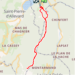
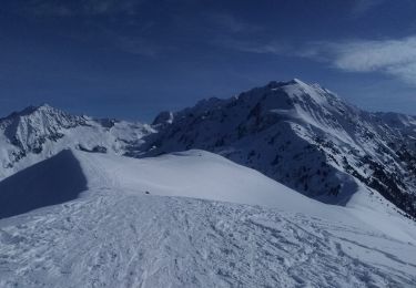
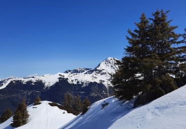
Randonnée Raquettes à neige de 17,2 km à découvrir à Auvergne-Rhône-Alpes, Isère, Allevard. Cette randonnée est proposée par lechner.
Description
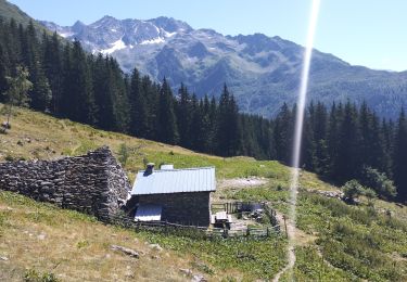
Laisser la voiture sur le parking du hameau de Montouvrard et prendre la direction du Carrefour du Jeu de Paume, puis du refuge du Lac des Tavernes. Vous pouvez ensuite monter jusqu'au refuge du Crêt du poulet. Ce refuge, tenu par des bénévoles, est ouvert en hivers et vous pouvez vous y restaurer ou simplement y boire une boisson chaude.
Localisation
Commentaires
Randonnées à proximité
![Randonnée Marche La Chapelle-du-Bard - Le Grand Charnier 2561m, par l'arête de l'Évêque - Photo](https://media.geolcdn.com/t/375/260/ext.jpg?maxdim=2&url=https%3A%2F%2Fservices.sitytrail.com%2FGeolivesWS%2FDownloadMedia.ashx%3FTrailID%3D102683%26Media%3D3706_1.jpg)
![Marche Marche](https://static1.geolcdn.com/sitytour/trail-icons/101.png)
Marche
![](/images/other/stat-length.png)
![](https://static1.geolcdn.com/siteimages/upload/files/16400158638029165_repeat_loop_refresh_sync_direction_icon.png)
![Randonnée Marche Le Haut-Bréda - Lac de Moretan avec bivouac - Photo](https://media.geolcdn.com/t/375/260/3f6f6c9a-9eda-4898-9aca-c8a8ce663caf.jpg&format=jpg&maxdim=2)
![Marche Marche](https://static1.geolcdn.com/sitytour/trail-icons/101.png)
Marche
![](/images/other/stat-length.png)
![](https://static1.geolcdn.com/siteimages/upload/files/16400158638029165_repeat_loop_refresh_sync_direction_icon.png)
![Randonnée Ski de randonnée Le Haut-Bréda - Col de Morétan - Photo](https://media.geolcdn.com/t/375/260/873ab7f9-f7ca-4112-a0d8-deee5e8e09db.jpg&format=jpg&maxdim=2)
![Ski de randonnée Ski de randonnée](https://static1.geolcdn.com/sitytour/trail-icons/503.png)
Ski de randonnée
![](/images/other/stat-length.png)
![](https://static1.geolcdn.com/siteimages/upload/files/16400158638029165_repeat_loop_refresh_sync_direction_icon.png)
![Randonnée Marche Le Haut-Bréda - Montagne de Périoule - Photo](https://media.geolcdn.com/t/375/260/2f5383cd-a0ab-4c06-9cbc-7601a3f9dca7.jpg&format=jpg&maxdim=2)
![Marche Marche](https://static1.geolcdn.com/sitytour/trail-icons/101.png)
Marche
![](/images/other/stat-length.png)
![](https://static1.geolcdn.com/siteimages/upload/files/16400158638029165_repeat_loop_refresh_sync_direction_icon.png)
![Randonnée Ski de randonnée La Chapelle-du-Bard - Crête de la Plagne descente Nord - Photo](https://media.geolcdn.com/t/375/260/a18dcbf8-7d05-4d6a-95a3-6473edcc6b7f.jpg&format=jpg&maxdim=2)
![Ski de randonnée Ski de randonnée](https://static1.geolcdn.com/sitytour/trail-icons/503.png)
Ski de randonnée
![](/images/other/stat-length.png)
![](https://static1.geolcdn.com/siteimages/upload/files/16400158638029165_repeat_loop_refresh_sync_direction_icon.png)
![Randonnée Marche Crêts-en-Belledonne - Brame Farine St Pierre Allevard - Photo](https://media.geolcdn.com/t/375/260/5306a5e1-46b2-422e-a183-63928def1b48.jpg&format=jpg&maxdim=2)
![Marche Marche](https://static1.geolcdn.com/sitytour/trail-icons/101.png)
Marche
![](/images/other/stat-length.png)
![](https://static1.geolcdn.com/siteimages/upload/files/16400158638029165_repeat_loop_refresh_sync_direction_icon.png)
![Randonnée Marche Le Haut-Bréda - Refuge de l'Oule - Croix et Lac du Léat - Photo](https://media.geolcdn.com/t/375/260/078c0fe6-5867-4c5f-8f9e-655ab5779903.jpg&format=jpg&maxdim=2)
![Marche Marche](https://static1.geolcdn.com/sitytour/trail-icons/101.png)
Marche
![](/images/other/stat-length.png)
![](https://static1.geolcdn.com/siteimages/upload/files/16400158638029165_repeat_loop_refresh_sync_direction_icon.png)
![Randonnée Marche Le Haut-Bréda - Lac et Croix du Léat - Photo](https://media.geolcdn.com/t/375/260/baf05127-eb6f-4a23-a9cc-3889b7723c4a.jpg&format=jpg&maxdim=2)
![Marche Marche](https://static1.geolcdn.com/sitytour/trail-icons/101.png)
Marche
![](/images/other/stat-length.png)
![](https://static1.geolcdn.com/siteimages/upload/files/16400158638029165_repeat_loop_refresh_sync_direction_icon.png)
![Randonnée Marche La Chapelle-du-Bard - Col de l'Occiput en raquettes - Photo](https://media.geolcdn.com/t/375/260/097b251d-d4e3-4eff-83ad-ca4286267be3.jpg&format=jpg&maxdim=2)
![Marche Marche](https://static1.geolcdn.com/sitytour/trail-icons/101.png)
Marche
![](/images/other/stat-length.png)
![](https://static1.geolcdn.com/siteimages/upload/files/16400158638029165_repeat_loop_refresh_sync_direction_icon.png)