![](/images/other/stat-length.png)
![Randonnée Marche Vœgtlinshoffen - 2020-06-12 Abbaye de Marbach / Bildstoeckle - Photo](https://media.geolcdn.com/t/1900/400/ext.pjpeg?maxdim=2&url=https%3A%2F%2Fmedia.geolcdn.com%2Ff%2F4f1b8e2c-a6ca-4088-9404-a7aeb617025c.jpg)
2020-06-12 Abbaye de Marbach / Bildstoeckle
ABICHE
Utilisateur
![Longueur](/images/other/stat-length.png)
Longueur
10,5 km
![Altitude max](https://static1.geolcdn.com/siteimages/upload/files/1508320355ic_sort_altitude_max_24dp.png)
Altitude max
755 m
![Dénivelé positif](https://static1.geolcdn.com/siteimages/upload/files/1508320355ic_sort_den_pos_24dp.png)
Dénivelé positif
403 m
![Km-Effort](/images/other/stat-length.png)
Km-Effort
15,8 km
![Altitude min](https://static1.geolcdn.com/siteimages/upload/files/1508320355ic_sort_altitude_min_24dp.png)
Altitude min
395 m
![Dénivelé négatif](https://static1.geolcdn.com/siteimages/upload/files/1508320355ic_sort_den_neg_24dp.png)
Dénivelé négatif
384 m
![Boucle](https://static1.geolcdn.com/siteimages/upload/files/16400158638029165_repeat_loop_refresh_sync_direction_icon.png)
Boucle
Oui
Date de création :
2020-06-12 07:56:17.009
Dernière modification :
2020-06-28 11:55:45.388
![Marche](https://static1.geolcdn.com/sitytour/trail-icons/101.png)
3h39
Difficulté : Moyen
![Scannez ce code QR pour ouvrir la randonnée dans l'application SityTrail](https://capi.geolives.com/qq0zvz2zws4bq2lad0pu/sitytour/trails/2434035/qr.png?size=200)
Application GPS de randonnée GRATUITE
À propos
Randonnée Marche de 10,5 km à découvrir à Grand Est, Haut-Rhin, Vœgtlinshoffen. Cette randonnée est proposée par ABICHE.
Description
Randonnée qui débute par une longue montée sur des chemins faciles jusqu'au Bildstoeckle. Possibilité de picnic au col de Hattstatt.
Localisation
Pays :
France
Région :
Grand Est
Département/Province :
Haut-Rhin
Commune :
Vœgtlinshoffen
Localité :
Unknown
Départ:(Dec)
Départ:(UTM)
371444 ; 5320419 (32U) N.
Commentaires
Randonnées à proximité
![Randonnée Marche Wettolsheim - 4 châteaux Wettolsheim Husseren - Photo](https://media.geolcdn.com/t/375/260/ext.jpg?maxdim=2&url=https%3A%2F%2Fmedia.geolcdn.com%2Ff%2F3d38d7b6-fe96-472e-849b-8dfa9ade163e.jpg)
![Marche Marche](https://static1.geolcdn.com/sitytour/trail-icons/101.png)
4 châteaux Wettolsheim Husseren
Marche
Moyen
(1)
Wettolsheim,
Grand Est,
Haut-Rhin,
France
![](/images/other/stat-length.png)
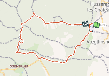
11,7 km | 17,7 km-effort
4h 28min
![](https://static1.geolcdn.com/siteimages/upload/files/16400158638029165_repeat_loop_refresh_sync_direction_icon.png)
Non
![Randonnée Marche Osenbach - Osenbach - Sentier des Sols - Photo](https://media.geolcdn.com/t/375/260/ext.jpg?maxdim=2&url=https%3A%2F%2Fmedia.geolcdn.com%2Ff%2F6c9ac6ed-dd66-44f3-ac1e-534ef34ca26a.JPG)
![Marche Marche](https://static1.geolcdn.com/sitytour/trail-icons/101.png)
Osenbach - Sentier des Sols
Marche
Facile
(1)
Osenbach,
Grand Est,
Haut-Rhin,
France
![](/images/other/stat-length.png)
4,7 km | 6,6 km-effort
3h 0min
![](https://static1.geolcdn.com/siteimages/upload/files/16400158638029165_repeat_loop_refresh_sync_direction_icon.png)
Oui
![Randonnée Marche Eguisheim - 2023-12-29 Marche Hagueneck Pflixbourg Hohlandsbourg - Photo](https://media.geolcdn.com/t/375/260/ext.jpg?maxdim=2&url=https%3A%2F%2Fmedia.geolcdn.com%2Ff%2Fdcbc603a-6326-4148-957e-2ff1d984719d.jpg)
![Marche Marche](https://static1.geolcdn.com/sitytour/trail-icons/101.png)
2023-12-29 Marche Hagueneck Pflixbourg Hohlandsbourg
Marche
Moyen
Eguisheim,
Grand Est,
Haut-Rhin,
France
![](/images/other/stat-length.png)
22 km | 32 km-effort
7h 16min
![](https://static1.geolcdn.com/siteimages/upload/files/16400158638029165_repeat_loop_refresh_sync_direction_icon.png)
Oui
![Randonnée Marche Pfaffenheim - Schauenberg 1 - Photo](https://media.geolcdn.com/t/375/260/ext.jpg?maxdim=2&url=https%3A%2F%2Fstatic1.geolcdn.com%2Fsiteimages%2Fupload%2Ffiles%2F1553511878bg_sport_marche.png)
![Marche Marche](https://static1.geolcdn.com/sitytour/trail-icons/101.png)
Schauenberg 1
Marche
Facile
(1)
Pfaffenheim,
Grand Est,
Haut-Rhin,
France
![](/images/other/stat-length.png)
10,3 km | 16,5 km-effort
3h 30min
![](https://static1.geolcdn.com/siteimages/upload/files/16400158638029165_repeat_loop_refresh_sync_direction_icon.png)
Oui
![Randonnée A pied Walbach - wihr au val - le petit hohnack - Photo](https://media.geolcdn.com/t/375/260/ext.jpg?maxdim=2&url=https%3A%2F%2Fstatic1.geolcdn.com%2Fsiteimages%2Fupload%2Ffiles%2F1545311037marcheuse_200dpi.jpg)
![A pied A pied](https://static1.geolcdn.com/sitytour/trail-icons/100.png)
wihr au val - le petit hohnack
A pied
Moyen
(1)
Walbach,
Grand Est,
Haut-Rhin,
France
![](/images/other/stat-length.png)
15,6 km | 25 km-effort
5h 46min
![](https://static1.geolcdn.com/siteimages/upload/files/16400158638029165_repeat_loop_refresh_sync_direction_icon.png)
Oui
![Randonnée Marche Husseren-les-Châteaux - Husseren les Châteaux - Photo](https://media.geolcdn.com/t/375/260/ext.jpg?maxdim=2&url=https%3A%2F%2Fmedia.geolcdn.com%2Ff%2Ffbdaec15-f3be-4264-9cbd-289a37b2f125.jpg)
![Marche Marche](https://static1.geolcdn.com/sitytour/trail-icons/101.png)
Husseren les Châteaux
Marche
Facile
Husseren-les-Châteaux,
Grand Est,
Haut-Rhin,
France
![](/images/other/stat-length.png)
12,7 km | 19,1 km-effort
3h 24min
![](https://static1.geolcdn.com/siteimages/upload/files/16400158638029165_repeat_loop_refresh_sync_direction_icon.png)
Oui
![Randonnée Marche Gueberschwihr - Les Marcheurs...et la fondue..26/01/2024 - Photo](https://media.geolcdn.com/t/375/260/ext.jpg?maxdim=2&url=https%3A%2F%2Fmedia.geolcdn.com%2Ff%2Fad885384-60ff-44a9-b1fd-e61a666f77f3.jpg)
![Marche Marche](https://static1.geolcdn.com/sitytour/trail-icons/101.png)
Les Marcheurs...et la fondue..26/01/2024
Marche
Moyen
Gueberschwihr,
Grand Est,
Haut-Rhin,
France
![](/images/other/stat-length.png)
20 km | 31 km-effort
4h 59min
![](https://static1.geolcdn.com/siteimages/upload/files/16400158638029165_repeat_loop_refresh_sync_direction_icon.png)
Oui
![Randonnée Marche Eguisheim - Rando des cinq châteaux - Photo](https://media.geolcdn.com/t/375/260/ext.jpg?maxdim=2&url=https%3A%2F%2Fmedia.geolcdn.com%2Ff%2F8226c9f6-a93f-4b2e-a6d9-b8f8a4c5665a.jpg)
![Marche Marche](https://static1.geolcdn.com/sitytour/trail-icons/101.png)
Rando des cinq châteaux
Marche
Moyen
Eguisheim,
Grand Est,
Haut-Rhin,
France
![](/images/other/stat-length.png)
18,4 km | 28 km-effort
5h 19min
![](https://static1.geolcdn.com/siteimages/upload/files/16400158638029165_repeat_loop_refresh_sync_direction_icon.png)
Oui
![Randonnée Marche Gueberschwihr - Promenade circulaire Kuckuckstei - Photo](https://media.geolcdn.com/t/375/260/ext.jpg?maxdim=2&url=https%3A%2F%2Fmedia.geolcdn.com%2Ff%2Faa86f8e7-d4e1-4258-9749-fac279d85298.jpg)
![Marche Marche](https://static1.geolcdn.com/sitytour/trail-icons/101.png)
Promenade circulaire Kuckuckstei
Marche
Moyen
Gueberschwihr,
Grand Est,
Haut-Rhin,
France
![](/images/other/stat-length.png)
7 km | 10,5 km-effort
2h 57min
![](https://static1.geolcdn.com/siteimages/upload/files/16400158638029165_repeat_loop_refresh_sync_direction_icon.png)
Oui