![](/images/other/stat-length.png)
![Randonnée V.T.C. Gujan-Mestras - 2020-06-10 Tour du Bassin d'Arcachon depuis La Hume - Photo](https://media.geolcdn.com/t/1900/400/ext.pjpeg?maxdim=2&url=https%3A%2F%2Fstatic1.geolcdn.com%2Fsiteimages%2Fupload%2Ffiles%2F1524743154velo.jpg)
2020-06-10 Tour du Bassin d'Arcachon depuis La Hume
eric.mignot
Utilisateur
![Longueur](/images/other/stat-length.png)
![Altitude max](https://static1.geolcdn.com/siteimages/upload/files/1508320355ic_sort_altitude_max_24dp.png)
![Dénivelé positif](https://static1.geolcdn.com/siteimages/upload/files/1508320355ic_sort_den_pos_24dp.png)
![Km-Effort](/images/other/stat-length.png)
![Altitude min](https://static1.geolcdn.com/siteimages/upload/files/1508320355ic_sort_altitude_min_24dp.png)
![Dénivelé négatif](https://static1.geolcdn.com/siteimages/upload/files/1508320355ic_sort_den_neg_24dp.png)
![Boucle](https://static1.geolcdn.com/siteimages/upload/files/16400158638029165_repeat_loop_refresh_sync_direction_icon.png)
![V.T.C.](https://static1.geolcdn.com/sitytour/trail-icons/203.png)
8h55
Difficulté : Moyen
![Scannez ce code QR pour ouvrir la randonnée dans l'application SityTrail](https://capi.geolives.com/qq0zvz2zws4bq2lad0pu/sitytour/trails/2431580/qr.png?size=200)
Application GPS de randonnée GRATUITE
À propos
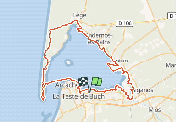
Randonnée V.T.C. de 106 km à découvrir à Nouvelle-Aquitaine, Gironde, Gujan-Mestras. Cette randonnée est proposée par eric.mignot.
Description
sur la presqu'île, entre la pointe du cap et Lège: par les pistes cyclables;
par un itinéraire perso dans le delta de la Leyre, entre le port de Biganos et Lamothe;
partout ailleurs, en suivant le GRP, essentiellement sur le sentier du littoral;
durée totale : 12h, avec 1h de pause pour le déjeuner.
Localisation
Commentaires
Randonnées à proximité
![Randonnée Marche La Teste-de-Buch - les prés salés La teste - Photo](https://media.geolcdn.com/t/375/260/86be3924-c0ab-4aef-aa85-26c1d81d9feb.jpg&format=jpg&maxdim=2)
![Marche Marche](https://static1.geolcdn.com/sitytour/trail-icons/101.png)
Marche
![](/images/other/stat-length.png)
![](https://static1.geolcdn.com/siteimages/upload/files/16400158638029165_repeat_loop_refresh_sync_direction_icon.png)
![Randonnée Vélo La Teste-de-Buch - Petit tour du lac de Cazaux - Photo](https://media.geolcdn.com/t/375/260/ext.jpg?maxdim=2&url=https%3A%2F%2Fstatic1.geolcdn.com%2Fsiteimages%2Fupload%2Ffiles%2F1524743154velo.jpg)
![Vélo Vélo](https://static1.geolcdn.com/sitytour/trail-icons/200.png)
Vélo
![](/images/other/stat-length.png)
![](https://static1.geolcdn.com/siteimages/upload/files/16400158638029165_repeat_loop_refresh_sync_direction_icon.png)
![Randonnée Marche Arcachon - Arcachon la Ville d'hiver 12.4.23 - Photo](https://media.geolcdn.com/t/375/260/0f63231a-28b2-43af-9681-63c0b1170e0b.jpg&format=jpg&maxdim=2)
![Marche Marche](https://static1.geolcdn.com/sitytour/trail-icons/101.png)
Marche
![](/images/other/stat-length.png)
![](https://static1.geolcdn.com/siteimages/upload/files/16400158638029165_repeat_loop_refresh_sync_direction_icon.png)
![Randonnée Vélo de route Arcachon - Les 7 Ports de Gujan-Mestras 10.4.23 - Photo](https://media.geolcdn.com/t/375/260/213dfc89-ffa2-46b8-937f-c84c5fcea237.jpg&format=jpg&maxdim=2)
![Vélo de route Vélo de route](https://static1.geolcdn.com/sitytour/trail-icons/201.png)
Vélo de route
![](/images/other/stat-length.png)
![](https://static1.geolcdn.com/siteimages/upload/files/16400158638029165_repeat_loop_refresh_sync_direction_icon.png)
![Randonnée Autre activité Arcachon - Arcachon - Ville d'hivers en train - Photo](https://media.geolcdn.com/t/375/260/4e028493-ab15-4bc2-939a-aa95fe826031.jpg&format=jpg&maxdim=2)
![Autre activité Autre activité](https://static1.geolcdn.com/sitytour/trail-icons/900.png)
Autre activité
![](/images/other/stat-length.png)
![](https://static1.geolcdn.com/siteimages/upload/files/16400158638029165_repeat_loop_refresh_sync_direction_icon.png)
![Randonnée Marche Arcachon - Cap Ferret - Photo](https://media.geolcdn.com/t/375/260/4357a232-66f1-489d-8cf5-6ae07a45b22a.jpg&format=jpg&maxdim=2)
![Marche Marche](https://static1.geolcdn.com/sitytour/trail-icons/101.png)
Marche
![](/images/other/stat-length.png)
![](https://static1.geolcdn.com/siteimages/upload/files/16400158638029165_repeat_loop_refresh_sync_direction_icon.png)
![Randonnée Bateau à moteur Arcachon - Samedi 18/07 randobateau - Photo](https://media.geolcdn.com/t/375/260/e2d4611d-4530-46ac-8ef4-ac29eadd9a06.jpg&format=jpg&maxdim=2)
![Bateau à moteur Bateau à moteur](https://static1.geolcdn.com/sitytour/trail-icons/701.png)
Bateau à moteur
![](/images/other/stat-length.png)
![](https://static1.geolcdn.com/siteimages/upload/files/16400158638029165_repeat_loop_refresh_sync_direction_icon.png)
![Randonnée Marche La Teste-de-Buch - les prés salés ouest - Photo](https://media.geolcdn.com/t/375/260/8d55b261-46ee-4fee-b4e3-b587276c9c55.jpg&format=jpg&maxdim=2)
![Marche Marche](https://static1.geolcdn.com/sitytour/trail-icons/101.png)
Marche
![](/images/other/stat-length.png)
![](https://static1.geolcdn.com/siteimages/upload/files/16400158638029165_repeat_loop_refresh_sync_direction_icon.png)
![Randonnée Marche Arcachon - ARCACHON Ville d'Hiver et Parc Mauresque - Photo](https://media.geolcdn.com/t/375/260/ext.jpg?maxdim=2&url=https%3A%2F%2Fstatic1.geolcdn.com%2Fsiteimages%2Fupload%2Ffiles%2F1553511878bg_sport_marche.png)
![Marche Marche](https://static1.geolcdn.com/sitytour/trail-icons/101.png)
Marche
![](/images/other/stat-length.png)
![](https://static1.geolcdn.com/siteimages/upload/files/16400158638029165_repeat_loop_refresh_sync_direction_icon.png)