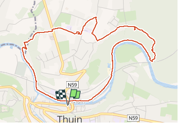
![](/images/other/stat-length.png)
![Randonnée Marche Thuin - Balade de Thuin au Hameau des Waibes - Photo](https://media.geolcdn.com/t/1900/400/bbe85e66-9d91-4f3f-9e30-5ef5dacfe1fb.jpg&format=pjpeg&maxdim=2)
Balade de Thuin au Hameau des Waibes
Desrumaux
Utilisateur GUIDE
![Longueur](/images/other/stat-length.png)
![Altitude max](https://static1.geolcdn.com/siteimages/upload/files/1508320355ic_sort_altitude_max_24dp.png)
![Dénivelé positif](https://static1.geolcdn.com/siteimages/upload/files/1508320355ic_sort_den_pos_24dp.png)
![Km-Effort](/images/other/stat-length.png)
![Altitude min](https://static1.geolcdn.com/siteimages/upload/files/1508320355ic_sort_altitude_min_24dp.png)
![Dénivelé négatif](https://static1.geolcdn.com/siteimages/upload/files/1508320355ic_sort_den_neg_24dp.png)
![Boucle](https://static1.geolcdn.com/siteimages/upload/files/16400158638029165_repeat_loop_refresh_sync_direction_icon.png)
![Marche](https://static1.geolcdn.com/sitytour/trail-icons/101.png)
3h17
Difficulté : Très facile
![Scannez ce code QR pour ouvrir la randonnée dans l'application SityTrail](https://capi.geolives.com/qq0zvz2zws4bq2lad0pu/sitytour/trails/2427556/qr.png?size=200)
Application GPS de randonnée GRATUITE
À propos
Randonnée Marche de 6 km à découvrir à Wallonie, Hainaut, Thuin. Cette randonnée est proposée par Desrumaux.
Description
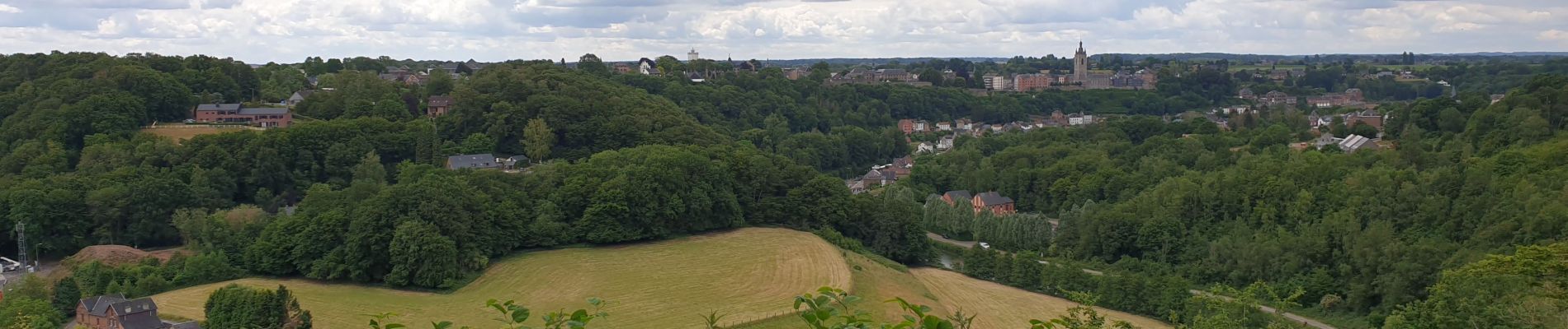
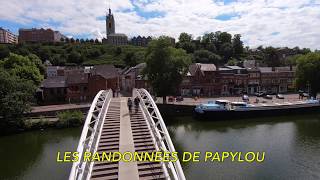
La promenade prend son départ sur la place de la Ville Basse en empruntant la nouvelle passerelle qui enjambe la Sambre pour atteindre le chemin de halage pour se diriger vers le hameau des Waibes. La balade prend de la hauteur via un sentier escarpé avec des jolis points de vues sur la ville de Thuin et son beffroi, (attention la descente vers la Sambre est pentu, éviter les périodes pluvieuse).
C'est au fil de l'eau que la boucle se referme.
Localisation
Commentaires
Randonnées à proximité
![Randonnée Marche Fontaine-l'Évêque - de l'Abbaye d'Aulne au hameau de Hourpes - Thuin - Photo](https://media.geolcdn.com/t/375/260/a34a09f7-2ebf-4334-b3ab-6307c79b316f.jpeg&format=jpg&maxdim=2)
![Marche Marche](https://static1.geolcdn.com/sitytour/trail-icons/101.png)
Marche
![](/images/other/stat-length.png)
![](https://static1.geolcdn.com/siteimages/upload/files/16400158638029165_repeat_loop_refresh_sync_direction_icon.png)
![Randonnée Marche Thuin - La balade du Bois des Waibes. - Photo](https://media.geolcdn.com/t/375/260/ext.jpg?maxdim=2&url=https%3A%2F%2Fservices.sitytrail.com%2FGeolivesWS%2FDownloadMedia.ashx%3FTrailID%3D846785%26Media%3D2a15c231-0cbe-4107-9b4e-b0ca15c25a1f.jpg)
![Marche Marche](https://static1.geolcdn.com/sitytour/trail-icons/101.png)
Marche
![](/images/other/stat-length.png)
![](https://static1.geolcdn.com/siteimages/upload/files/16400158638029165_repeat_loop_refresh_sync_direction_icon.png)
![Randonnée Marche Montigny-le-Tilleul - Balade en Val de Sambre - De Landelies à l'Abbaye d'Aulne - Photo](https://media.geolcdn.com/t/375/260/ext.jpg?maxdim=2&url=https%3A%2F%2Fservices.sitytrail.com%2FGeolivesWS%2FDownloadMedia.ashx%3FTrailID%3D498562%26Media%3D0c817a37-45f6-4c22-ab94-a572de965186.JPG)
![Marche Marche](https://static1.geolcdn.com/sitytour/trail-icons/101.png)
Marche
![](/images/other/stat-length.png)
![](https://static1.geolcdn.com/siteimages/upload/files/16400158638029165_repeat_loop_refresh_sync_direction_icon.png)
![Randonnée Marche Lobbes - Balade à Mont-Sainte-Geneviève - Photo](https://media.geolcdn.com/t/375/260/ext.jpg?maxdim=2&url=https%3A%2F%2Fservices.sitytrail.com%2FGeolivesWS%2FDownloadMedia.ashx%3FTrailID%3D378767%26Media%3D9ad7b20e-c031-407f-875d-742351009cf4.jpg)
![Marche Marche](https://static1.geolcdn.com/sitytour/trail-icons/101.png)
Marche
![](/images/other/stat-length.png)
![](https://static1.geolcdn.com/siteimages/upload/files/16400158638029165_repeat_loop_refresh_sync_direction_icon.png)
![Randonnée Marche Thuin - RB-Ha-08 - Thuin - Via allongement - Photo](https://media.geolcdn.com/t/375/260/ext.jpg?maxdim=2&url=https%3A%2F%2Fservices.sitytrail.com%2FGeolivesWS%2FDownloadMedia.ashx%3FTrailID%3D218762%26Media%3D7e0b1de5-2210-4f38-aa84-2fca8ae33ab8.jpg)
![Marche Marche](https://static1.geolcdn.com/sitytour/trail-icons/101.png)
Marche
![](/images/other/stat-length.png)
![](https://static1.geolcdn.com/siteimages/upload/files/16400158638029165_repeat_loop_refresh_sync_direction_icon.png)
![Randonnée Marche Thuin - RB-Ha-08 - Thuin - Photo](https://media.geolcdn.com/t/375/260/ext.jpg?maxdim=2&url=https%3A%2F%2Fservices.sitytrail.com%2FGeolivesWS%2FDownloadMedia.ashx%3FTrailID%3D179601%26Media%3D33d5cfdf-1096-4ca0-9209-00c5bbfd32f4.jpg)
![Marche Marche](https://static1.geolcdn.com/sitytour/trail-icons/101.png)
Marche
![](/images/other/stat-length.png)
![](https://static1.geolcdn.com/siteimages/upload/files/16400158638029165_repeat_loop_refresh_sync_direction_icon.png)
![Randonnée Marche Thuin - Thuin - De la Ville Haute à la Ville Basse - Photo](https://media.geolcdn.com/t/375/260/ext.jpg?maxdim=2&url=https%3A%2F%2Fservices.sitytrail.com%2FGeolivesWS%2FDownloadMedia.ashx%3FTrailID%3D96827%26Media%3Da38cc2d0-85a8-4251-9b00-ce6dea30fa93.JPG)
![Marche Marche](https://static1.geolcdn.com/sitytour/trail-icons/101.png)
Marche
![](/images/other/stat-length.png)
![](https://static1.geolcdn.com/siteimages/upload/files/16400158638029165_repeat_loop_refresh_sync_direction_icon.png)
![Randonnée Marche Lobbes - LOBBES (vers Hourpes) dép RHS - Photo](https://media.geolcdn.com/t/375/260/d9a7042e-0c53-41c5-a007-94b83a09ecc3.jpg&format=jpg&maxdim=2)
![Marche Marche](https://static1.geolcdn.com/sitytour/trail-icons/101.png)
Marche
![](/images/other/stat-length.png)
![](https://static1.geolcdn.com/siteimages/upload/files/16400158638029165_repeat_loop_refresh_sync_direction_icon.png)
![Randonnée Marche Thuin - Ragnies - Photo](https://media.geolcdn.com/t/375/260/8ab2079a-6e03-4639-b2a2-057277a8cea4.jpg&format=jpg&maxdim=2)
![Marche Marche](https://static1.geolcdn.com/sitytour/trail-icons/101.png)
Marche
![](/images/other/stat-length.png)
![](https://static1.geolcdn.com/siteimages/upload/files/16400158638029165_repeat_loop_refresh_sync_direction_icon.png)