![](/images/other/stat-length.png)
![Randonnée A pied Comblain-au-Pont - Rando bière : Poulseur - Photo](https://media.geolcdn.com/t/1900/400/1749b977-1bef-4828-9f9a-307985926e7d.jpg&format=pjpeg&maxdim=2)
Rando bière : Poulseur
Rando bière
Hiking inspiration PRO
![Longueur](/images/other/stat-length.png)
![Altitude max](https://static1.geolcdn.com/siteimages/upload/files/1508320355ic_sort_altitude_max_24dp.png)
![Dénivelé positif](https://static1.geolcdn.com/siteimages/upload/files/1508320355ic_sort_den_pos_24dp.png)
![Km-Effort](/images/other/stat-length.png)
![Altitude min](https://static1.geolcdn.com/siteimages/upload/files/1508320355ic_sort_altitude_min_24dp.png)
![Dénivelé négatif](https://static1.geolcdn.com/siteimages/upload/files/1508320355ic_sort_den_neg_24dp.png)
![Boucle](https://static1.geolcdn.com/siteimages/upload/files/16400158638029165_repeat_loop_refresh_sync_direction_icon.png)
![A pied](https://static1.geolcdn.com/sitytour/trail-icons/100.png)
5h00
Difficulté : Moyen
![Scannez ce code QR pour ouvrir la randonnée dans l'application SityTrail](https://capi.geolives.com/qq0zvz2zws4bq2lad0pu/sitytour/trails/2422059/qr.png?size=200)
Application GPS de randonnée GRATUITE
À propos
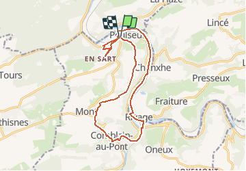
Randonnée A pied de 14,6 km à découvrir à Wallonie, Liège, Comblain-au-Pont. Cette randonnée est proposée par Rando bière.
Description
Hello, 😁
Je vous propose de me rejoindre pour une rando/bière du côté de Poulseur !
👣 15KM : 288 D 📈 et 288D -📉
⏳ Durée moyenne : entre 4h et 5h
🚗 27 minutes depuis Liège (23KM)
⚪ : rando peu exigeante physiquement
💧Prévoir au moins 2L d'eau (minimum)
🥾 Prévoir des chaussures de marche
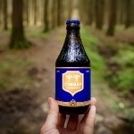
🍻 Poul's Bar : http://www.lepoulsbar.be/
🌡Météo : https://www.meteoblue.com/fr/meteo/semaine/poulseur_belgique_2788666
Passage possible devant la microbrasserie en fin de parcours (les 3 derniers km après le retour dans le centre de Poulseur) pour les curieux mais il n'y à rien de particulier à voir...
Localisation
Commentaires
Randonnées à proximité
![Randonnée Marche Esneux - Esneux bois du mary - Photo](https://media.geolcdn.com/t/375/260/71c77441-f9b7-4220-bb0a-fbf9c3317653.jpg&format=jpg&maxdim=2)
![Marche Marche](https://static1.geolcdn.com/sitytour/trail-icons/101.png)
Marche
![](/images/other/stat-length.png)
![](https://static1.geolcdn.com/siteimages/upload/files/16400158638029165_repeat_loop_refresh_sync_direction_icon.png)
![Randonnée Marche Neupré - Neupré - les contreforts de la Boucle de l'Ourthe - Photo](https://media.geolcdn.com/t/375/260/ext.jpg?maxdim=2&url=https%3A%2F%2Fservices.sitytrail.com%2FGeolivesWS%2FDownloadMedia.ashx%3FTrailID%3D347434%26Media%3Dfix__20140909180027.jpg)
![Marche Marche](https://static1.geolcdn.com/sitytour/trail-icons/101.png)
Marche
![](/images/other/stat-length.png)
![](https://static1.geolcdn.com/siteimages/upload/files/16400158638029165_repeat_loop_refresh_sync_direction_icon.png)
![Randonnée Marche Esneux - RB-Lg-10_Esneux_via-racc - Photo](https://media.geolcdn.com/t/375/260/ext.jpg?maxdim=2&url=https%3A%2F%2Fservices.sitytrail.com%2FGeolivesWS%2FDownloadMedia.ashx%3FTrailID%3D209422%26Media%3D464c3dd7-df43-4893-8019-c771f2bd17f1.jpg)
![Marche Marche](https://static1.geolcdn.com/sitytour/trail-icons/101.png)
Marche
![](/images/other/stat-length.png)
![](https://static1.geolcdn.com/siteimages/upload/files/16400158638029165_repeat_loop_refresh_sync_direction_icon.png)
![Marche Marche](https://static1.geolcdn.com/sitytour/trail-icons/101.png)
Marche
![](/images/other/stat-length.png)
![](https://static1.geolcdn.com/siteimages/upload/files/16400158638029165_repeat_loop_refresh_sync_direction_icon.png)
![Randonnée Marche Esneux - RB-Lg-10_Esneux - Photo](https://media.geolcdn.com/t/375/260/ext.jpg?maxdim=2&url=https%3A%2F%2Fservices.sitytrail.com%2FGeolivesWS%2FDownloadMedia.ashx%3FTrailID%3D179568%26Media%3D18c2b0fe-ccb1-462d-9e89-f89259226c52.jpg)
![Marche Marche](https://static1.geolcdn.com/sitytour/trail-icons/101.png)
Marche
![](/images/other/stat-length.png)
![](https://static1.geolcdn.com/siteimages/upload/files/16400158638029165_repeat_loop_refresh_sync_direction_icon.png)
![Randonnée Marche Comblain-au-Pont - RF-Lg-04_Comblain-au-Pont_Grande-boucle - Photo](https://media.geolcdn.com/t/375/260/b6c1584e-1801-407f-b05d-19d8f1862ff5.jpg&format=jpg&maxdim=2)
![Marche Marche](https://static1.geolcdn.com/sitytour/trail-icons/101.png)
Marche
![](/images/other/stat-length.png)
![](https://static1.geolcdn.com/siteimages/upload/files/16400158638029165_repeat_loop_refresh_sync_direction_icon.png)
![Randonnée Marche Neupré - Neupré - Sentier Paysage et Géologie - Photo](https://media.geolcdn.com/t/375/260/ext.jpg?maxdim=2&url=https%3A%2F%2Fservices.sitytrail.com%2FGeolivesWS%2FDownloadMedia.ashx%3FTrailID%3D343711%26Media%3Dfix__20140909182657.jpg)
![Marche Marche](https://static1.geolcdn.com/sitytour/trail-icons/101.png)
Marche
![](/images/other/stat-length.png)
![](https://static1.geolcdn.com/siteimages/upload/files/16400158638029165_repeat_loop_refresh_sync_direction_icon.png)
![Randonnée Marche Neupré - Neupré - Balade du Chemin des morts - Photo](https://media.geolcdn.com/t/375/260/ext.jpg?maxdim=2&url=https%3A%2F%2Fstatic1.geolcdn.com%2Fsiteimages%2Fupload%2Ffiles%2F1553511878bg_sport_marche.png)
![Marche Marche](https://static1.geolcdn.com/sitytour/trail-icons/101.png)
Marche
![](/images/other/stat-length.png)
![](https://static1.geolcdn.com/siteimages/upload/files/16400158638029165_repeat_loop_refresh_sync_direction_icon.png)
![Randonnée Marche Esneux - Esneux - Parc du Mary - Photo](https://media.geolcdn.com/t/375/260/a932a506-f892-4455-93af-64f2fda79c4c.jpg&format=jpg&maxdim=2)
![Marche Marche](https://static1.geolcdn.com/sitytour/trail-icons/101.png)
Marche
![](/images/other/stat-length.png)
![](https://static1.geolcdn.com/siteimages/upload/files/16400158638029165_repeat_loop_refresh_sync_direction_icon.png)