![](/images/other/stat-length.png)
![Randonnée Marche nordique Saint-Germain-en-Laye - caves du nord - étang du Corra 10km - Photo](https://media.geolcdn.com/t/1900/400/ext.pjpeg?maxdim=2&url=https%3A%2F%2Fstatic1.geolcdn.com%2Fsiteimages%2Fupload%2Ffiles%2F1545311037marcheuse_200dpi.jpg)
caves du nord - étang du Corra 10km
jpdhouilles
Utilisateur
![Longueur](/images/other/stat-length.png)
Longueur
10,4 km
![Altitude max](https://static1.geolcdn.com/siteimages/upload/files/1508320355ic_sort_altitude_max_24dp.png)
Altitude max
57 m
![Dénivelé positif](https://static1.geolcdn.com/siteimages/upload/files/1508320355ic_sort_den_pos_24dp.png)
Dénivelé positif
76 m
![Km-Effort](/images/other/stat-length.png)
Km-Effort
11,4 km
![Altitude min](https://static1.geolcdn.com/siteimages/upload/files/1508320355ic_sort_altitude_min_24dp.png)
Altitude min
22 m
![Dénivelé négatif](https://static1.geolcdn.com/siteimages/upload/files/1508320355ic_sort_den_neg_24dp.png)
Dénivelé négatif
76 m
![Boucle](https://static1.geolcdn.com/siteimages/upload/files/16400158638029165_repeat_loop_refresh_sync_direction_icon.png)
Boucle
Oui
Date de création :
2020-06-01 16:36:50.013
Dernière modification :
2020-06-01 16:44:07.839
![Marche nordique](https://static1.geolcdn.com/sitytour/trail-icons/102.png)
1h40
Difficulté : Facile
![Scannez ce code QR pour ouvrir la randonnée dans l'application SityTrail](https://capi.geolives.com/qq0zvz2zws4bq2lad0pu/sitytour/trails/2421439/qr.png?size=200)
Application GPS de randonnée GRATUITE
À propos
Randonnée Marche nordique de 10,4 km à découvrir à Île-de-France, Yvelines, Saint-Germain-en-Laye. Cette randonnée est proposée par jpdhouilles.
Description
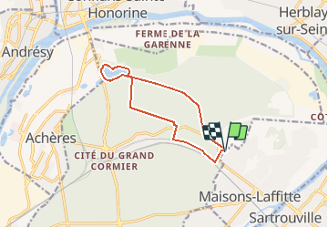
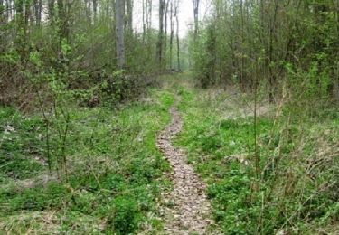
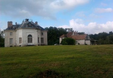
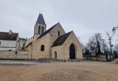
MN . Départ des caves du nord (parc Maisons Laffitte, jusqu'a l'étang du Corra et retour. 10kms. difficulté : facile
Localisation
Pays :
France
Région :
Île-de-France
Département/Province :
Yvelines
Commune :
Saint-Germain-en-Laye
Localité :
Saint-Germain-en-Laye
Départ:(Dec)
Départ:(UTM)
436719 ; 5423062 (31U) N.
Commentaires
Randonnées à proximité
![Randonnée A pied Conflans-Sainte-Honorine - Version définitive Conflans 7 janvier - Photo](https://media.geolcdn.com/t/375/260/2f5b666a-1419-402d-9c3e-8de986f24ebf.jpg&format=jpg&maxdim=2)
![A pied A pied](https://static1.geolcdn.com/sitytour/trail-icons/100.png)
Version définitive Conflans 7 janvier
A pied
Moyen
(1)
Conflans-Sainte-Honorine,
Île-de-France,
Yvelines,
France
![](/images/other/stat-length.png)
23 km | 28 km-effort
6h 22min
![](https://static1.geolcdn.com/siteimages/upload/files/16400158638029165_repeat_loop_refresh_sync_direction_icon.png)
Non
![Randonnée Marche Saint-Germain-en-Laye - GRP CV-IDF 04R Saint-Germain-en-Laye à Jouy-le-Moutier - Photo](https://media.geolcdn.com/t/375/260/9864db54-c566-4b60-8ec4-15499d0119f8.jpg&format=jpg&maxdim=2)
![Marche Marche](https://static1.geolcdn.com/sitytour/trail-icons/101.png)
GRP CV-IDF 04R Saint-Germain-en-Laye à Jouy-le-Moutier
Marche
Très difficile
(1)
Saint-Germain-en-Laye,
Île-de-France,
Yvelines,
France
![](/images/other/stat-length.png)
16,5 km | 19,1 km-effort
4h 21min
![](https://static1.geolcdn.com/siteimages/upload/files/16400158638029165_repeat_loop_refresh_sync_direction_icon.png)
Non
![Randonnée Marche Saint-Germain-en-Laye - circuit MA 271019 - Photo](https://media.geolcdn.com/t/375/260/ec0c3cc2-4262-481e-ac4c-e608d5354784.jpg&format=jpg&maxdim=2)
![Marche Marche](https://static1.geolcdn.com/sitytour/trail-icons/101.png)
circuit MA 271019
Marche
Très facile
(1)
Saint-Germain-en-Laye,
Île-de-France,
Yvelines,
France
![](/images/other/stat-length.png)
4,7 km | 5,2 km-effort
1h 3min
![](https://static1.geolcdn.com/siteimages/upload/files/16400158638029165_repeat_loop_refresh_sync_direction_icon.png)
Oui
![Randonnée Marche Maisons-Laffitte - Forêt de Saint Germain en Laye - Photo](https://media.geolcdn.com/t/375/260/ext.jpg?maxdim=2&url=https%3A%2F%2Fservices.sitytrail.com%2FGeolivesWS%2FDownloadMedia.ashx%3FTrailID%3D110160%26Media%3D5360_1.jpg)
![Marche Marche](https://static1.geolcdn.com/sitytour/trail-icons/101.png)
Forêt de Saint Germain en Laye
Marche
Difficile
(2)
Maisons-Laffitte,
Île-de-France,
Yvelines,
France
![](/images/other/stat-length.png)
22 km | 25 km-effort
4h 30min
![](https://static1.geolcdn.com/siteimages/upload/files/16400158638029165_repeat_loop_refresh_sync_direction_icon.png)
Oui
![Randonnée Marche Saint-Germain-en-Laye - D'Achères Grand Cormier à Maison Laffitte - Photo](https://media.geolcdn.com/t/375/260/ext.jpg?maxdim=2&url=https%3A%2F%2Fservices.sitytrail.com%2FGeolivesWS%2FDownloadMedia.ashx%3FTrailID%3D106827%26Media%3D11535_2.jpg)
![Marche Marche](https://static1.geolcdn.com/sitytour/trail-icons/101.png)
D'Achères Grand Cormier à Maison Laffitte
Marche
Moyen
(1)
Saint-Germain-en-Laye,
Île-de-France,
Yvelines,
France
![](/images/other/stat-length.png)
12,9 km | 14,4 km-effort
3h 0min
![](https://static1.geolcdn.com/siteimages/upload/files/16400158638029165_repeat_loop_refresh_sync_direction_icon.png)
Non
![Randonnée Marche Le Mesnil-le-Roi - RS 5 km porte chene corbeau - Photo](https://media.geolcdn.com/t/375/260/ext.jpg?maxdim=2&url=https%3A%2F%2Fstatic1.geolcdn.com%2Fsiteimages%2Fupload%2Ffiles%2F1553511878bg_sport_marche.png)
![Marche Marche](https://static1.geolcdn.com/sitytour/trail-icons/101.png)
RS 5 km porte chene corbeau
Marche
Facile
(1)
Le Mesnil-le-Roi,
Île-de-France,
Yvelines,
France
![](/images/other/stat-length.png)
5,2 km | 5,8 km-effort
1h 18min
![](https://static1.geolcdn.com/siteimages/upload/files/16400158638029165_repeat_loop_refresh_sync_direction_icon.png)
Oui
![Randonnée A pied Conflans-Sainte-Honorine - Conflans fin d'oise - Andresy - La Frette - Photo](https://media.geolcdn.com/t/375/260/43572d18-a869-49dd-98f4-125a083ecdd2.jpg&format=jpg&maxdim=2)
![A pied A pied](https://static1.geolcdn.com/sitytour/trail-icons/100.png)
Conflans fin d'oise - Andresy - La Frette
A pied
Moyen
Conflans-Sainte-Honorine,
Île-de-France,
Yvelines,
France
![](/images/other/stat-length.png)
22 km | 27 km-effort
6h 14min
![](https://static1.geolcdn.com/siteimages/upload/files/16400158638029165_repeat_loop_refresh_sync_direction_icon.png)
Non
![Randonnée Marche Saint-Germain-en-Laye - 20230824 5S 5KM - Photo](https://media.geolcdn.com/t/375/260/ext.jpg?maxdim=2&url=https%3A%2F%2Fstatic1.geolcdn.com%2Fsiteimages%2Fupload%2Ffiles%2F1553511878bg_sport_marche.png)
![Marche Marche](https://static1.geolcdn.com/sitytour/trail-icons/101.png)
20230824 5S 5KM
Marche
Moyen
(1)
Saint-Germain-en-Laye,
Île-de-France,
Yvelines,
France
![](/images/other/stat-length.png)
5,5 km | 6,3 km-effort
1h 25min
![](https://static1.geolcdn.com/siteimages/upload/files/16400158638029165_repeat_loop_refresh_sync_direction_icon.png)
Oui
![Randonnée Marche Saint-Germain-en-Laye - 20230519 RS 5km - Photo](https://media.geolcdn.com/t/375/260/ext.jpg?maxdim=2&url=https%3A%2F%2Fstatic1.geolcdn.com%2Fsiteimages%2Fupload%2Ffiles%2F1553511878bg_sport_marche.png)
![Marche Marche](https://static1.geolcdn.com/sitytour/trail-icons/101.png)
20230519 RS 5km
Marche
Facile
(1)
Saint-Germain-en-Laye,
Île-de-France,
Yvelines,
France
![](/images/other/stat-length.png)
5 km | 5,6 km-effort
1h 16min
![](https://static1.geolcdn.com/siteimages/upload/files/16400158638029165_repeat_loop_refresh_sync_direction_icon.png)
Oui