![](/images/other/stat-length.png)
![Randonnée Marche Saint-Cézaire-sur-Siagne - les balcons de la Siagne - Photo](https://media.geolcdn.com/t/1900/400/136fa414-f020-40c8-9d64-ce15acfc48f9.jpg&format=pjpeg&maxdim=2)
les balcons de la Siagne
Palimpseste
Utilisateur
![Longueur](/images/other/stat-length.png)
Longueur
9,2 km
![Altitude max](https://static1.geolcdn.com/siteimages/upload/files/1508320355ic_sort_altitude_max_24dp.png)
Altitude max
748 m
![Dénivelé positif](https://static1.geolcdn.com/siteimages/upload/files/1508320355ic_sort_den_pos_24dp.png)
Dénivelé positif
403 m
![Km-Effort](/images/other/stat-length.png)
Km-Effort
14,5 km
![Altitude min](https://static1.geolcdn.com/siteimages/upload/files/1508320355ic_sort_altitude_min_24dp.png)
Altitude min
521 m
![Dénivelé négatif](https://static1.geolcdn.com/siteimages/upload/files/1508320355ic_sort_den_neg_24dp.png)
Dénivelé négatif
402 m
![Boucle](https://static1.geolcdn.com/siteimages/upload/files/16400158638029165_repeat_loop_refresh_sync_direction_icon.png)
Boucle
Oui
Date de création :
2020-06-01 12:59:21.75
Dernière modification :
2020-06-01 16:59:04.689
![Marche](https://static1.geolcdn.com/sitytour/trail-icons/101.png)
2h52
Difficulté : Difficile
![Scannez ce code QR pour ouvrir la randonnée dans l'application SityTrail](https://capi.geolives.com/qq0zvz2zws4bq2lad0pu/sitytour/trails/2421315/qr.png?size=200)
Application GPS de randonnée GRATUITE
À propos
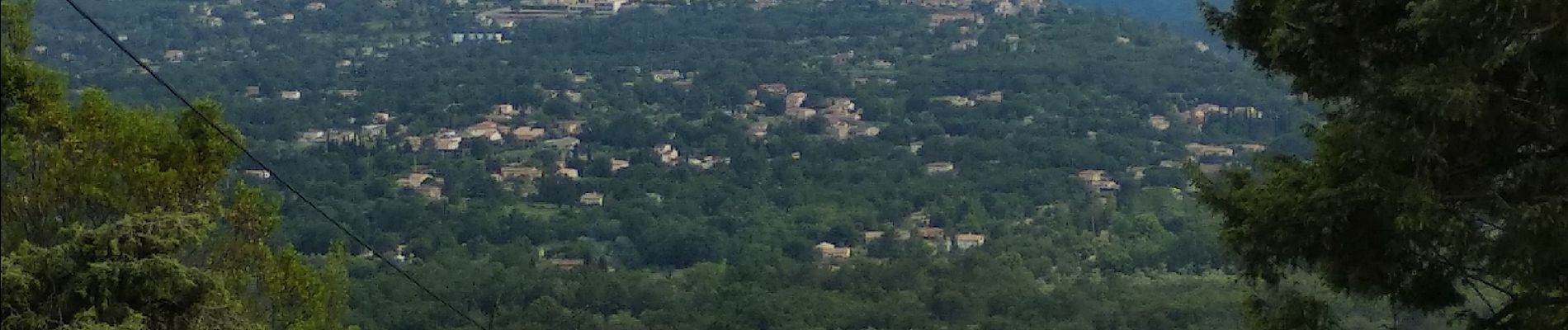
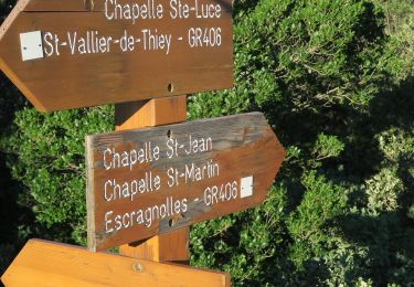
Randonnée Marche de 9,2 km à découvrir à Provence-Alpes-Côte d'Azur, Alpes-Maritimes, Saint-Cézaire-sur-Siagne. Cette randonnée est proposée par Palimpseste.
Description
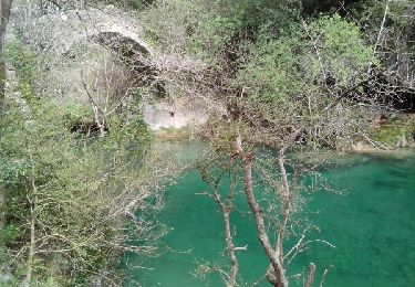
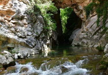
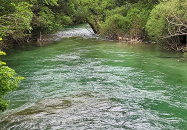
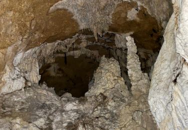
Ballade le long du GR 510 qui permet de surplomber la partie la plus inaccessible des gorges de la Siagne.
Passage au pied du site d''escalade des Malines aux falaises impressionnantes qui abritent de nombreux rapaces.
Localisation
Pays :
France
Région :
Provence-Alpes-Côte d'Azur
Département/Province :
Alpes-Maritimes
Commune :
Saint-Cézaire-sur-Siagne
Localité :
Unknown
Départ:(Dec)
Départ:(UTM)
321119 ; 4837711 (32T) N.
Commentaires
Randonnées à proximité
![Randonnée Marche Montauroux - Monteroux Gorges de la Siagne 04.04.2015 - Photo](https://media.geolcdn.com/t/375/260/ext.jpg?maxdim=2&url=https%3A%2F%2Fservices.sitytrail.com%2FGeolivesWS%2FDownloadMedia.ashx%3FTrailID%3D404141%26Media%3Dfix__20150404125312.jpg)
![Marche Marche](https://static1.geolcdn.com/sitytour/trail-icons/101.png)
Monteroux Gorges de la Siagne 04.04.2015
Marche
Facile
(1)
Montauroux,
Provence-Alpes-Côte d'Azur,
Var,
France
![](/images/other/stat-length.png)
11,8 km | 16,4 km-effort
3h 26min
![](https://static1.geolcdn.com/siteimages/upload/files/16400158638029165_repeat_loop_refresh_sync_direction_icon.png)
Oui
![Randonnée Marche Saint-Vallier-de-Thiey - Arche de Ponadieu Source de la Pare Baou Mourine Vieux Pont - Photo](https://media.geolcdn.com/t/375/260/7bf7c645-d759-4e3b-9f63-302e7218f005.jpg&format=jpg&maxdim=2)
![Marche Marche](https://static1.geolcdn.com/sitytour/trail-icons/101.png)
Arche de Ponadieu Source de la Pare Baou Mourine Vieux Pont
Marche
Très difficile
Saint-Vallier-de-Thiey,
Provence-Alpes-Côte d'Azur,
Alpes-Maritimes,
France
![](/images/other/stat-length.png)
19,2 km | 32 km-effort
7h 20min
![](https://static1.geolcdn.com/siteimages/upload/files/16400158638029165_repeat_loop_refresh_sync_direction_icon.png)
Oui
![Randonnée Marche Saint-Vallier-de-Thiey - St Vallier de Thiey - Aqueduc de Belletrud - Arche de Ponadieu - Photo](https://media.geolcdn.com/t/375/260/102f751b-e867-453b-847f-fc313f16fe9f.jpg&format=jpg&maxdim=2)
![Marche Marche](https://static1.geolcdn.com/sitytour/trail-icons/101.png)
St Vallier de Thiey - Aqueduc de Belletrud - Arche de Ponadieu
Marche
Très difficile
Saint-Vallier-de-Thiey,
Provence-Alpes-Côte d'Azur,
Alpes-Maritimes,
France
![](/images/other/stat-length.png)
18,5 km | 31 km-effort
6h 56min
![](https://static1.geolcdn.com/siteimages/upload/files/16400158638029165_repeat_loop_refresh_sync_direction_icon.png)
Oui
![Randonnée Marche Saint-Cézaire-sur-Siagne - Col de Cabris - Photo](https://media.geolcdn.com/t/375/260/ext.jpg?maxdim=2&url=https%3A%2F%2Fstatic1.geolcdn.com%2Fsiteimages%2Fupload%2Ffiles%2F1553511878bg_sport_marche.png)
![Marche Marche](https://static1.geolcdn.com/sitytour/trail-icons/101.png)
Col de Cabris
Marche
Facile
(1)
Saint-Cézaire-sur-Siagne,
Provence-Alpes-Côte d'Azur,
Alpes-Maritimes,
France
![](/images/other/stat-length.png)
7,3 km | 9,7 km-effort
3h 0min
![](https://static1.geolcdn.com/siteimages/upload/files/16400158638029165_repeat_loop_refresh_sync_direction_icon.png)
Oui
![Randonnée Marche Saint-Cézaire-sur-Siagne - st cezaire siagne - Photo](https://media.geolcdn.com/t/375/260/ext.jpg?maxdim=2&url=https%3A%2F%2Fstatic1.geolcdn.com%2Fsiteimages%2Fupload%2Ffiles%2F1553511878bg_sport_marche.png)
![Marche Marche](https://static1.geolcdn.com/sitytour/trail-icons/101.png)
st cezaire siagne
Marche
Très facile
(1)
Saint-Cézaire-sur-Siagne,
Provence-Alpes-Côte d'Azur,
Alpes-Maritimes,
France
![](/images/other/stat-length.png)
6,9 km | 11,4 km-effort
2h 42min
![](https://static1.geolcdn.com/siteimages/upload/files/16400158638029165_repeat_loop_refresh_sync_direction_icon.png)
Non
![Marche Marche](https://static1.geolcdn.com/sitytour/trail-icons/101.png)
St Vallier de Thiey - Col de la Lèque - Chapelle St Jean - Arche Ponadieu
Marche
Moyen
Saint-Vallier-de-Thiey,
Provence-Alpes-Côte d'Azur,
Alpes-Maritimes,
France
![](/images/other/stat-length.png)
14,1 km | 21 km-effort
4h 44min
![](https://static1.geolcdn.com/siteimages/upload/files/16400158638029165_repeat_loop_refresh_sync_direction_icon.png)
Oui
![Randonnée Marche Saint-Cézaire-sur-Siagne - Le canal et la rivière de la Siagne - Photo](https://media.geolcdn.com/t/375/260/8dec3c8f-da07-4204-a170-c1946b688755.jpg&format=jpg&maxdim=2)
![Marche Marche](https://static1.geolcdn.com/sitytour/trail-icons/101.png)
Le canal et la rivière de la Siagne
Marche
Moyen
Saint-Cézaire-sur-Siagne,
Provence-Alpes-Côte d'Azur,
Alpes-Maritimes,
France
![](/images/other/stat-length.png)
8,4 km | 13,9 km-effort
3h 8min
![](https://static1.geolcdn.com/siteimages/upload/files/16400158638029165_repeat_loop_refresh_sync_direction_icon.png)
Oui
![Randonnée Marche Saint-Vallier-de-Thiey - St Vallier : Pare2 - Photo](https://media.geolcdn.com/t/375/260/0e23e1f7-5365-422d-9e17-aca855b1fa8e.jpeg&format=jpg&maxdim=2)
![Marche Marche](https://static1.geolcdn.com/sitytour/trail-icons/101.png)
St Vallier : Pare2
Marche
Difficile
Saint-Vallier-de-Thiey,
Provence-Alpes-Côte d'Azur,
Alpes-Maritimes,
France
![](/images/other/stat-length.png)
17,7 km | 29 km-effort
6h 35min
![](https://static1.geolcdn.com/siteimages/upload/files/16400158638029165_repeat_loop_refresh_sync_direction_icon.png)
Oui
![Randonnée Marche Saint-Vallier-de-Thiey - St Vallier : Ponadieu et Pare - Photo](https://media.geolcdn.com/t/375/260/cd1c5cbe-cdfc-442d-b46e-04ba15662bae.jpeg&format=jpg&maxdim=2)
![Marche Marche](https://static1.geolcdn.com/sitytour/trail-icons/101.png)
St Vallier : Ponadieu et Pare
Marche
Difficile
Saint-Vallier-de-Thiey,
Provence-Alpes-Côte d'Azur,
Alpes-Maritimes,
France
![](/images/other/stat-length.png)
19,3 km | 33 km-effort
7h 31min
![](https://static1.geolcdn.com/siteimages/upload/files/16400158638029165_repeat_loop_refresh_sync_direction_icon.png)
Oui