![](/images/other/stat-length.png)
![Randonnée Marche Gorniès - la seŕanne - Photo](https://media.geolcdn.com/t/1900/400/dc1ebfbf-d275-4923-8573-14042f68c5e4.jpg&format=pjpeg&maxdim=2)
la seŕanne
labarone
Utilisateur
![Longueur](/images/other/stat-length.png)
Longueur
17,2 km
![Altitude max](https://static1.geolcdn.com/siteimages/upload/files/1508320355ic_sort_altitude_max_24dp.png)
Altitude max
924 m
![Dénivelé positif](https://static1.geolcdn.com/siteimages/upload/files/1508320355ic_sort_den_pos_24dp.png)
Dénivelé positif
820 m
![Km-Effort](/images/other/stat-length.png)
Km-Effort
28 km
![Altitude min](https://static1.geolcdn.com/siteimages/upload/files/1508320355ic_sort_altitude_min_24dp.png)
Altitude min
157 m
![Dénivelé négatif](https://static1.geolcdn.com/siteimages/upload/files/1508320355ic_sort_den_neg_24dp.png)
Dénivelé négatif
858 m
![Boucle](https://static1.geolcdn.com/siteimages/upload/files/16400158638029165_repeat_loop_refresh_sync_direction_icon.png)
Boucle
Non
Date de création :
2020-05-26 07:44:34.313
Dernière modification :
2020-05-26 15:01:31.122
![Marche](https://static1.geolcdn.com/sitytour/trail-icons/101.png)
6h30
Difficulté : Moyen
![Scannez ce code QR pour ouvrir la randonnée dans l'application SityTrail](https://capi.geolives.com/qq0zvz2zws4bq2lad0pu/sitytour/trails/2412108/qr.png?size=200)
Application GPS de randonnée GRATUITE
À propos
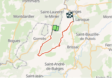
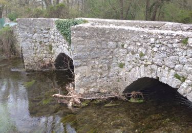
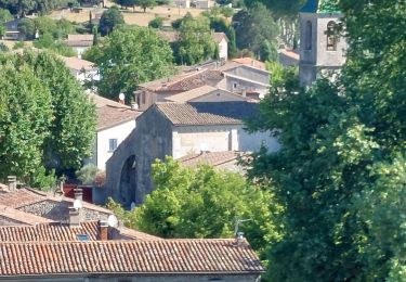
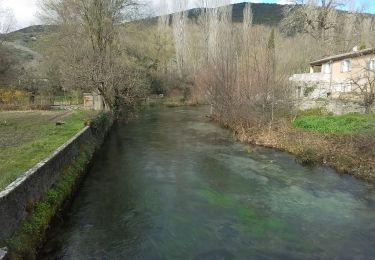
Randonnée Marche de 17,2 km à découvrir à Occitanie, Hérault, Gorniès. Cette randonnée est proposée par labarone.
Description
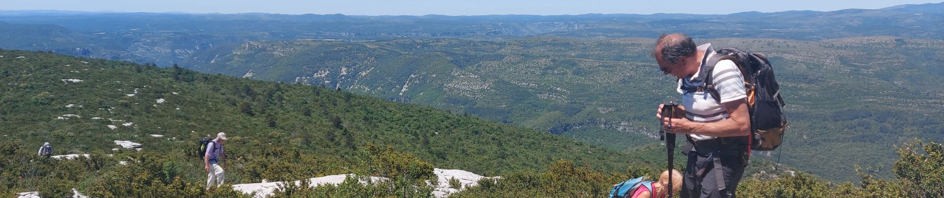
attention ne pas démarrer de souteyrol car chemin impraticable(ronce et pierrier) Partir plutôt de Planteyrol qui débouche sur la seranne. Arrivée au Roc blanc : vue magique. Descente un peu longue...
Localisation
Pays :
France
Région :
Occitanie
Département/Province :
Hérault
Commune :
Gorniès
Localité :
Unknown
Départ:(Dec)
Départ:(UTM)
552558 ; 4860695 (31T) N.
Commentaires
Randonnées à proximité
![Randonnée Marche Ganges - les Mines de Ganges - Photo](https://media.geolcdn.com/t/375/260/ext.jpg?maxdim=2&url=https%3A%2F%2Fservices.sitytrail.com%2FGeolivesWS%2FDownloadMedia.ashx%3FTrailID%3D835756%26Media%3D20170926145921.jpg)
![Marche Marche](https://static1.geolcdn.com/sitytour/trail-icons/101.png)
les Mines de Ganges
Marche
Moyen
(4)
Ganges,
Occitanie,
Hérault,
France
![](/images/other/stat-length.png)
12 km | 17,5 km-effort
5h 30min
![](https://static1.geolcdn.com/siteimages/upload/files/16400158638029165_repeat_loop_refresh_sync_direction_icon.png)
Oui
![Randonnée Marche Brissac - Brissac à Croix Ste Micisse - Photo](https://media.geolcdn.com/t/375/260/59e2c1f3-52eb-417b-9103-ff63004fd457.jpg&format=jpg&maxdim=2)
![Marche Marche](https://static1.geolcdn.com/sitytour/trail-icons/101.png)
Brissac à Croix Ste Micisse
Marche
Moyen
Brissac,
Occitanie,
Hérault,
France
![](/images/other/stat-length.png)
19,8 km | 28 km-effort
6h 1min
![](https://static1.geolcdn.com/siteimages/upload/files/16400158638029165_repeat_loop_refresh_sync_direction_icon.png)
Oui
![Randonnée Marche Brissac - 34 brissac - Photo](https://media.geolcdn.com/t/375/260/60cabbc4-5250-488d-a0c0-023fee13261d.jpg&format=jpg&maxdim=2)
![Marche Marche](https://static1.geolcdn.com/sitytour/trail-icons/101.png)
![Randonnée Marche Saint-Laurent-le-Minier - pic et grotte d Anneau au depart de St Laurent le Minier - Photo](https://media.geolcdn.com/t/375/260/f8302bfe-8e81-4700-a65e-4420a9b2464f.jpg&format=jpg&maxdim=2)
![Marche Marche](https://static1.geolcdn.com/sitytour/trail-icons/101.png)
pic et grotte d Anneau au depart de St Laurent le Minier
Marche
Difficile
Saint-Laurent-le-Minier,
Occitanie,
Gard,
France
![](/images/other/stat-length.png)
16,4 km | 27 km-effort
7h 38min
![](https://static1.geolcdn.com/siteimages/upload/files/16400158638029165_repeat_loop_refresh_sync_direction_icon.png)
Oui
![Randonnée Marche Saint-Laurent-le-Minier - Saint-Laurent-du-Minier - grotte d'Anjeau - tour du pic d'Anjeau - cascade de la Vis - Photo](https://media.geolcdn.com/t/375/260/ext.jpg?maxdim=2&url=https%3A%2F%2Fstatic1.geolcdn.com%2Fsiteimages%2Fupload%2Ffiles%2F1553511878bg_sport_marche.png)
![Marche Marche](https://static1.geolcdn.com/sitytour/trail-icons/101.png)
Saint-Laurent-du-Minier - grotte d'Anjeau - tour du pic d'Anjeau - cascade de...
Marche
Moyen
(2)
Saint-Laurent-le-Minier,
Occitanie,
Gard,
France
![](/images/other/stat-length.png)
13,5 km | 23 km-effort
4h 52min
![](https://static1.geolcdn.com/siteimages/upload/files/16400158638029165_repeat_loop_refresh_sync_direction_icon.png)
Oui
![Randonnée Marche Brissac - Brissac - abime Rabanel - Roc Blanc - Notre-Dame-du-Suc - Photo](https://media.geolcdn.com/t/375/260/ext.jpg?maxdim=2&url=https%3A%2F%2Fstatic1.geolcdn.com%2Fsiteimages%2Fupload%2Ffiles%2F1553511878bg_sport_marche.png)
![Marche Marche](https://static1.geolcdn.com/sitytour/trail-icons/101.png)
Brissac - abime Rabanel - Roc Blanc - Notre-Dame-du-Suc
Marche
Moyen
(1)
Brissac,
Occitanie,
Hérault,
France
![](/images/other/stat-length.png)
18,2 km | 29 km-effort
6h 7min
![](https://static1.geolcdn.com/siteimages/upload/files/16400158638029165_repeat_loop_refresh_sync_direction_icon.png)
Oui
![Randonnée Marche Brissac - autour de Brissac - Photo](https://media.geolcdn.com/t/375/260/ext.jpg?maxdim=2&url=https%3A%2F%2Fstatic1.geolcdn.com%2Fsiteimages%2Fupload%2Ffiles%2F1553511878bg_sport_marche.png)
![Marche Marche](https://static1.geolcdn.com/sitytour/trail-icons/101.png)
autour de Brissac
Marche
Difficile
(2)
Brissac,
Occitanie,
Hérault,
France
![](/images/other/stat-length.png)
20 km | 33 km-effort
6h 42min
![](https://static1.geolcdn.com/siteimages/upload/files/16400158638029165_repeat_loop_refresh_sync_direction_icon.png)
Oui
![Randonnée Marche Brissac - Brissac, ND du Suc, Papeterie - Photo](https://media.geolcdn.com/t/375/260/ec2e77c9-6145-40a7-84ea-5c5a7ac5c9ab.jpg&format=jpg&maxdim=2)
![Marche Marche](https://static1.geolcdn.com/sitytour/trail-icons/101.png)
Brissac, ND du Suc, Papeterie
Marche
Moyen
Brissac,
Occitanie,
Hérault,
France
![](/images/other/stat-length.png)
8,9 km | 12,5 km-effort
2h 50min
![](https://static1.geolcdn.com/siteimages/upload/files/16400158638029165_repeat_loop_refresh_sync_direction_icon.png)
Oui
![Randonnée A pied Brissac - BRISSAC- les trois termes aller retour - Photo](https://media.geolcdn.com/t/375/260/007e983e-6bab-4a06-be51-05d6cb6a7218.jpg&format=jpg&maxdim=2)
![A pied A pied](https://static1.geolcdn.com/sitytour/trail-icons/100.png)
BRISSAC- les trois termes aller retour
A pied
Moyen
Brissac,
Occitanie,
Hérault,
France
![](/images/other/stat-length.png)
18 km | 28 km-effort
6h 21min
![](https://static1.geolcdn.com/siteimages/upload/files/16400158638029165_repeat_loop_refresh_sync_direction_icon.png)
Oui