![](/images/other/stat-length.png)
![Randonnée Marche Cabrespine - Cabrespine - Photo](https://media.geolcdn.com/t/1900/400/ext.pjpeg?maxdim=2&url=https%3A%2F%2Fstatic1.geolcdn.com%2Fsiteimages%2Fupload%2Ffiles%2F1553511878bg_sport_marche.png)
Cabrespine
SoleilMoussanais
Utilisateur
![Longueur](/images/other/stat-length.png)
Longueur
10,8 km
![Altitude max](https://static1.geolcdn.com/siteimages/upload/files/1508320355ic_sort_altitude_max_24dp.png)
Altitude max
655 m
![Dénivelé positif](https://static1.geolcdn.com/siteimages/upload/files/1508320355ic_sort_den_pos_24dp.png)
Dénivelé positif
420 m
![Km-Effort](/images/other/stat-length.png)
Km-Effort
16,4 km
![Altitude min](https://static1.geolcdn.com/siteimages/upload/files/1508320355ic_sort_altitude_min_24dp.png)
Altitude min
302 m
![Dénivelé négatif](https://static1.geolcdn.com/siteimages/upload/files/1508320355ic_sort_den_neg_24dp.png)
Dénivelé négatif
418 m
![Boucle](https://static1.geolcdn.com/siteimages/upload/files/16400158638029165_repeat_loop_refresh_sync_direction_icon.png)
Boucle
Oui
Date de création :
2020-05-26 08:18:47.711
Dernière modification :
2020-05-26 15:38:28.575
![Marche](https://static1.geolcdn.com/sitytour/trail-icons/101.png)
5h35
Difficulté : Très facile
![Scannez ce code QR pour ouvrir la randonnée dans l'application SityTrail](https://capi.geolives.com/qq0zvz2zws4bq2lad0pu/sitytour/trails/2412030/qr.png?size=200)
Application GPS de randonnée GRATUITE
À propos
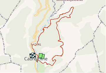
Randonnée Marche de 10,8 km à découvrir à Occitanie, Aude, Cabrespine. Cette randonnée est proposée par SoleilMoussanais.
Description
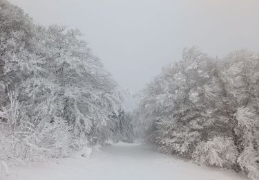
Les pas de l'aube. Randonnée de difficulté moyenne. Plus grande partie sous bois. Ruisseaux à traverser mais sans grande difficulté en mai,juin.
Localisation
Pays :
France
Région :
Occitanie
Département/Province :
Aude
Commune :
Cabrespine
Localité :
Unknown
Départ:(Dec)
Départ:(UTM)
456327 ; 4801108 (31T) N.
Commentaires
Randonnées à proximité
![Randonnée A pied Cabrespine - Les Villages Perchés - Photo](https://media.geolcdn.com/t/375/260/ext.jpg?maxdim=2&url=https%3A%2F%2Fmedia.geolcdn.com%2Ff%2F4379f8e7-e0a2-4ee4-810f-0aa42c1f51f8.jpeg)
![A pied A pied](https://static1.geolcdn.com/sitytour/trail-icons/100.png)
Les Villages Perchés
A pied
Facile
Cabrespine,
Occitanie,
Aude,
France
![](/images/other/stat-length.png)
8,3 km | 14,7 km-effort
3h 21min
![](https://static1.geolcdn.com/siteimages/upload/files/16400158638029165_repeat_loop_refresh_sync_direction_icon.png)
Non
![Randonnée A pied Cabrespine - Boucle du Gouffre de Cabrespine - Photo](https://media.geolcdn.com/t/375/260/ext.jpg?maxdim=2&url=https%3A%2F%2Fmedia.geolcdn.com%2Ff%2Fb4f79f08-71e0-4997-b690-a17cfd5f244e.jpeg)
![A pied A pied](https://static1.geolcdn.com/sitytour/trail-icons/100.png)
Boucle du Gouffre de Cabrespine
A pied
Facile
Cabrespine,
Occitanie,
Aude,
France
![](/images/other/stat-length.png)
4,9 km | 8,7 km-effort
1h 59min
![](https://static1.geolcdn.com/siteimages/upload/files/16400158638029165_repeat_loop_refresh_sync_direction_icon.png)
Non
![Randonnée Marche Villeneuve-Minervois - pujol de bosc castanviel - Photo](https://media.geolcdn.com/t/375/260/ext.jpg?maxdim=2&url=https%3A%2F%2Fmedia.geolcdn.com%2Ff%2F0e58840e-6e19-4149-b133-b9ac43c459d6.jpg)
![Marche Marche](https://static1.geolcdn.com/sitytour/trail-icons/101.png)
pujol de bosc castanviel
Marche
Facile
Villeneuve-Minervois,
Occitanie,
Aude,
France
![](/images/other/stat-length.png)
15,9 km | 23 km-effort
5h 20min
![](https://static1.geolcdn.com/siteimages/upload/files/16400158638029165_repeat_loop_refresh_sync_direction_icon.png)
Oui
![Randonnée Marche Sallèles-Cabardès - Sallèles Cabardès - Pradellles Cabardès - Pic du Nore- - Photo](https://media.geolcdn.com/t/375/260/ext.jpg?maxdim=2&url=https%3A%2F%2Fmedia.geolcdn.com%2Ff%2F90caa0b8-22c4-41a8-a0b4-9f5599ac34e4.jpg)
![Marche Marche](https://static1.geolcdn.com/sitytour/trail-icons/101.png)
Sallèles Cabardès - Pradellles Cabardès - Pic du Nore-
Marche
Très difficile
Sallèles-Cabardès,
Occitanie,
Aude,
France
![](/images/other/stat-length.png)
65 km | 0 m-effort
23h 36min
![](https://static1.geolcdn.com/siteimages/upload/files/16400158638029165_repeat_loop_refresh_sync_direction_icon.png)
Oui
![Randonnée Marche Sallèles-Cabardès - Reco Le Pic de Nore - Photo](https://media.geolcdn.com/t/375/260/ext.jpg?maxdim=2&url=https%3A%2F%2Fmedia.geolcdn.com%2Ff%2F81a42295-0bf8-4918-a48c-4464e99ea34e.jpg)
![Marche Marche](https://static1.geolcdn.com/sitytour/trail-icons/101.png)
Reco Le Pic de Nore
Marche
Très difficile
Sallèles-Cabardès,
Occitanie,
Aude,
France
![](/images/other/stat-length.png)
54 km | 79 km-effort
21h 27min
![](https://static1.geolcdn.com/siteimages/upload/files/16400158638029165_repeat_loop_refresh_sync_direction_icon.png)
Oui
![Randonnée Marche Limousis - Limousis - Photo](https://media.geolcdn.com/t/375/260/ext.jpg?maxdim=2&url=https%3A%2F%2Fmedia.geolcdn.com%2Ff%2Fc9382851-66d8-4f11-8490-1b66e63d0ad4.jpg)
![Marche Marche](https://static1.geolcdn.com/sitytour/trail-icons/101.png)
![Randonnée Marche Limousis - Mont Simel - Photo](https://media.geolcdn.com/t/375/260/ext.jpg?maxdim=2&url=https%3A%2F%2Fmedia.geolcdn.com%2Ff%2F38332c18-c5e2-4493-b4a7-4fa8f48f76d3.jpg)
![Marche Marche](https://static1.geolcdn.com/sitytour/trail-icons/101.png)
![Randonnée A pied Pradelles-Cabardès - Pradelles,roc de l'aigle,cabrespine,pradelles - Photo](https://media.geolcdn.com/t/375/260/ext.jpg?maxdim=2&url=https%3A%2F%2Fmedia.geolcdn.com%2Ff%2F82fe34a8-bde4-49e0-8e94-332d7cbba6cc.jpg)
![A pied A pied](https://static1.geolcdn.com/sitytour/trail-icons/100.png)
Pradelles,roc de l'aigle,cabrespine,pradelles
A pied
Difficile
Pradelles-Cabardès,
Occitanie,
Aude,
France
![](/images/other/stat-length.png)
15,3 km | 24 km-effort
5h 50min
![](https://static1.geolcdn.com/siteimages/upload/files/16400158638029165_repeat_loop_refresh_sync_direction_icon.png)
Oui
![Randonnée Marche Trassanel - trassanel gorges d'Escole RF - Photo](https://media.geolcdn.com/t/375/260/ext.jpg?maxdim=2&url=https%3A%2F%2Fstatic1.geolcdn.com%2Fsiteimages%2Fupload%2Ffiles%2F1553511878bg_sport_marche.png)
![Marche Marche](https://static1.geolcdn.com/sitytour/trail-icons/101.png)
trassanel gorges d'Escole RF
Marche
Moyen
(1)
Trassanel,
Occitanie,
Aude,
France
![](/images/other/stat-length.png)
8,7 km | 11,7 km-effort
3h 2min
![](https://static1.geolcdn.com/siteimages/upload/files/16400158638029165_repeat_loop_refresh_sync_direction_icon.png)
Oui