![](/images/other/stat-length.png)
![Randonnée Marche Cerre-lès-Noroy - Grand bois de Cerre les Noroy - Photo](https://media.geolcdn.com/t/1900/400/d57441b2-1aeb-4faa-9f6e-7bd13b9441a6.jpg&format=pjpeg&maxdim=2)
Grand bois de Cerre les Noroy
nicolasdresse
Utilisateur
![Longueur](/images/other/stat-length.png)
Longueur
10,8 km
![Altitude max](https://static1.geolcdn.com/siteimages/upload/files/1508320355ic_sort_altitude_max_24dp.png)
Altitude max
364 m
![Dénivelé positif](https://static1.geolcdn.com/siteimages/upload/files/1508320355ic_sort_den_pos_24dp.png)
Dénivelé positif
175 m
![Km-Effort](/images/other/stat-length.png)
Km-Effort
13,2 km
![Altitude min](https://static1.geolcdn.com/siteimages/upload/files/1508320355ic_sort_altitude_min_24dp.png)
Altitude min
296 m
![Dénivelé négatif](https://static1.geolcdn.com/siteimages/upload/files/1508320355ic_sort_den_neg_24dp.png)
Dénivelé négatif
176 m
![Boucle](https://static1.geolcdn.com/siteimages/upload/files/16400158638029165_repeat_loop_refresh_sync_direction_icon.png)
Boucle
Oui
Date de création :
2020-05-24 14:13:20.0
Dernière modification :
2020-05-24 17:36:22.004
![Marche](https://static1.geolcdn.com/sitytour/trail-icons/101.png)
3h22
Difficulté : Difficile
![Scannez ce code QR pour ouvrir la randonnée dans l'application SityTrail](https://capi.geolives.com/qq0zvz2zws4bq2lad0pu/sitytour/trails/2409820/qr.png?size=200)
Application GPS de randonnée GRATUITE
À propos
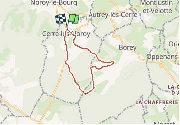
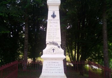
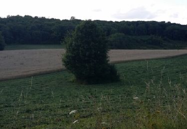
Randonnée Marche de 10,8 km à découvrir à Bourgogne-Franche-Comté, Haute-Saône, Cerre-lès-Noroy. Cette randonnée est proposée par nicolasdresse.
Description
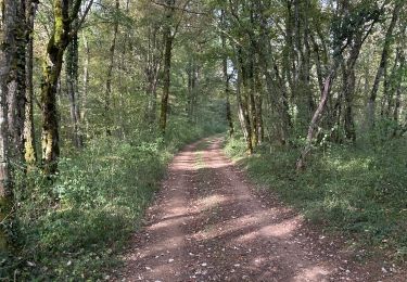
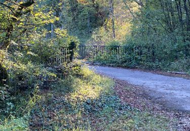
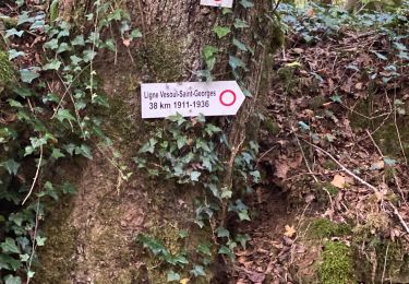
Randonnée agréable en sous bois , passage sympa sur 4 km de l’ancienne voie du tacot.
Passage par la fontaine à vin et les baraques de Borey.
Localisation
Pays :
France
Région :
Bourgogne-Franche-Comté
Département/Province :
Haute-Saône
Commune :
Cerre-lès-Noroy
Localité :
Unknown
Départ:(Dec)
Départ:(UTM)
298198 ; 5275446 (32T) N.
Commentaires
Randonnées à proximité
![Randonnée Marche Noroy-le-Bourg - Le sentier pédagogique de champfleurey - Photo](https://media.geolcdn.com/t/375/260/1ec00a77-aba6-4324-83b9-40bf283ac862.jpg&format=jpg&maxdim=2)
![Marche Marche](https://static1.geolcdn.com/sitytour/trail-icons/101.png)
Le sentier pédagogique de champfleurey
Marche
Moyen
Noroy-le-Bourg,
Bourgogne-Franche-Comté,
Haute-Saône,
France
![](/images/other/stat-length.png)
3,3 km | 4,6 km-effort
1h 48min
![](https://static1.geolcdn.com/siteimages/upload/files/16400158638029165_repeat_loop_refresh_sync_direction_icon.png)
Oui
![Randonnée Marche Noroy-le-Bourg - La Croix mercier - Photo](https://media.geolcdn.com/t/375/260/dbca0bb3-bb6f-4a4b-b32e-705e449c5ca5.jpg&format=jpg&maxdim=2)
![Marche Marche](https://static1.geolcdn.com/sitytour/trail-icons/101.png)
La Croix mercier
Marche
Moyen
Noroy-le-Bourg,
Bourgogne-Franche-Comté,
Haute-Saône,
France
![](/images/other/stat-length.png)
6,9 km | 8,6 km-effort
2h 12min
![](https://static1.geolcdn.com/siteimages/upload/files/16400158638029165_repeat_loop_refresh_sync_direction_icon.png)
Oui
![Randonnée Marche Noroy-le-Bourg - Noroy - le tacot- La Croix mercier -noroy - Photo](https://media.geolcdn.com/t/375/260/babbab5b-c2bd-45f3-bb41-0297a88dbf90.jpg&format=jpg&maxdim=2)
![Marche Marche](https://static1.geolcdn.com/sitytour/trail-icons/101.png)
Noroy - le tacot- La Croix mercier -noroy
Marche
Moyen
Noroy-le-Bourg,
Bourgogne-Franche-Comté,
Haute-Saône,
France
![](/images/other/stat-length.png)
6,1 km | 7,5 km-effort
1h 52min
![](https://static1.geolcdn.com/siteimages/upload/files/16400158638029165_repeat_loop_refresh_sync_direction_icon.png)
Oui
![Randonnée Marche Oppenans - OPPENANS 70 - Photo](https://media.geolcdn.com/t/375/260/1d0b76f7-1690-45c8-90af-183e843f809c.jpg&format=jpg&maxdim=2)
![Marche Marche](https://static1.geolcdn.com/sitytour/trail-icons/101.png)
OPPENANS 70
Marche
Moyen
Oppenans,
Bourgogne-Franche-Comté,
Haute-Saône,
France
![](/images/other/stat-length.png)
24 km | 31 km-effort
7h 35min
![](https://static1.geolcdn.com/siteimages/upload/files/16400158638029165_repeat_loop_refresh_sync_direction_icon.png)
Oui
![Randonnée Marche Noroy-le-Bourg - Circuit du veuvey prolongé - Photo](https://media.geolcdn.com/t/375/260/144bac1d-2ffc-4230-8c19-93676c892b8d.jpg&format=jpg&maxdim=2)
![Marche Marche](https://static1.geolcdn.com/sitytour/trail-icons/101.png)
Circuit du veuvey prolongé
Marche
Noroy-le-Bourg,
Bourgogne-Franche-Comté,
Haute-Saône,
France
![](/images/other/stat-length.png)
7 km | 9,4 km-effort
2h 13min
![](https://static1.geolcdn.com/siteimages/upload/files/16400158638029165_repeat_loop_refresh_sync_direction_icon.png)
Oui
![Randonnée Marche Noroy-le-Bourg - Les miroudot - Photo](https://media.geolcdn.com/t/375/260/c58403c0-25b7-4195-a630-687b5cf289df.jpg&format=jpg&maxdim=2)
![Marche Marche](https://static1.geolcdn.com/sitytour/trail-icons/101.png)
Les miroudot
Marche
Moyen
(1)
Noroy-le-Bourg,
Bourgogne-Franche-Comté,
Haute-Saône,
France
![](/images/other/stat-length.png)
7,1 km | 8,8 km-effort
2h 7min
![](https://static1.geolcdn.com/siteimages/upload/files/16400158638029165_repeat_loop_refresh_sync_direction_icon.png)
Oui
![Randonnée V.T.T. Cerre-lès-Noroy - Trail nocturne de Cerre les Noroy - Photo](https://media.geolcdn.com/t/375/260/ext.jpg?maxdim=2&url=https%3A%2F%2Fstatic1.geolcdn.com%2Fsiteimages%2Fupload%2Ffiles%2F1524743154velo.jpg)
![V.T.T. V.T.T.](https://static1.geolcdn.com/sitytour/trail-icons/202.png)
Trail nocturne de Cerre les Noroy
V.T.T.
Moyen
Cerre-lès-Noroy,
Bourgogne-Franche-Comté,
Haute-Saône,
France
![](/images/other/stat-length.png)
11,2 km | 14,1 km-effort
1h 34min
![](https://static1.geolcdn.com/siteimages/upload/files/16400158638029165_repeat_loop_refresh_sync_direction_icon.png)
Oui
![Randonnée Marche Noroy-le-Bourg - trou du tilleul - Photo](https://media.geolcdn.com/t/375/260/ext.jpg?maxdim=2&url=https%3A%2F%2Fservices.sitytrail.com%2FGeolivesWS%2FDownloadMedia.ashx%3FTrailID%3D326215%26Media%3Dfix__20140714191727.jpg)
![Marche Marche](https://static1.geolcdn.com/sitytour/trail-icons/101.png)
trou du tilleul
Marche
Facile
Noroy-le-Bourg,
Bourgogne-Franche-Comté,
Haute-Saône,
France
![](/images/other/stat-length.png)
3,8 km | 4,9 km-effort
1h 5min
![](https://static1.geolcdn.com/siteimages/upload/files/16400158638029165_repeat_loop_refresh_sync_direction_icon.png)
Oui
![Randonnée Marche Borey - Les baraques de borey- le creux qui sonne - bois de la brosse - Photo](https://media.geolcdn.com/t/375/260/ext.jpg?maxdim=2&url=https%3A%2F%2Fstatic1.geolcdn.com%2Fsiteimages%2Fupload%2Ffiles%2F1553511878bg_sport_marche.png)
![Marche Marche](https://static1.geolcdn.com/sitytour/trail-icons/101.png)
Les baraques de borey- le creux qui sonne - bois de la brosse
Marche
Moyen
Borey,
Bourgogne-Franche-Comté,
Haute-Saône,
France
![](/images/other/stat-length.png)
7,4 km | 9,1 km-effort
2h 12min
![](https://static1.geolcdn.com/siteimages/upload/files/16400158638029165_repeat_loop_refresh_sync_direction_icon.png)
Oui