![](/images/other/stat-length.png)
![Randonnée Marche Sarrancolin - Boucle Cap Nestes depuis Nistos - Photo](https://media.geolcdn.com/t/1900/400/ext.pjpeg?maxdim=2&url=https%3A%2F%2Fstatic1.geolcdn.com%2Fsiteimages%2Fupload%2Ffiles%2F1553511878bg_sport_marche.png)
Boucle Cap Nestes depuis Nistos
Rouzier
Utilisateur
![Longueur](/images/other/stat-length.png)
Longueur
10,4 km
![Altitude max](https://static1.geolcdn.com/siteimages/upload/files/1508320355ic_sort_altitude_max_24dp.png)
Altitude max
1865 m
![Dénivelé positif](https://static1.geolcdn.com/siteimages/upload/files/1508320355ic_sort_den_pos_24dp.png)
Dénivelé positif
470 m
![Km-Effort](/images/other/stat-length.png)
Km-Effort
16,6 km
![Altitude min](https://static1.geolcdn.com/siteimages/upload/files/1508320355ic_sort_altitude_min_24dp.png)
Altitude min
1587 m
![Dénivelé négatif](https://static1.geolcdn.com/siteimages/upload/files/1508320355ic_sort_den_neg_24dp.png)
Dénivelé négatif
469 m
![Boucle](https://static1.geolcdn.com/siteimages/upload/files/16400158638029165_repeat_loop_refresh_sync_direction_icon.png)
Boucle
Oui
Date de création :
2020-05-24 07:06:41.34
Dernière modification :
2020-05-24 17:26:12.131
![Marche](https://static1.geolcdn.com/sitytour/trail-icons/101.png)
5h03
Difficulté : Moyen
![Scannez ce code QR pour ouvrir la randonnée dans l'application SityTrail](https://capi.geolives.com/qq0zvz2zws4bq2lad0pu/sitytour/trails/2409802/qr.png?size=200)
Application GPS de randonnée GRATUITE
À propos
Randonnée Marche de 10,4 km à découvrir à Occitanie, Hautes-Pyrénées, Sarrancolin. Cette randonnée est proposée par Rouzier.
Description
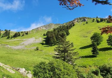
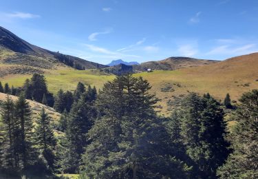
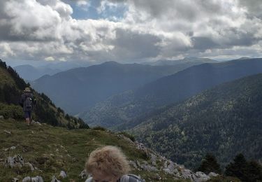
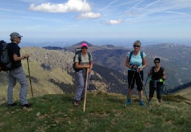
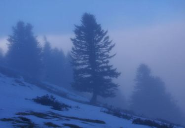
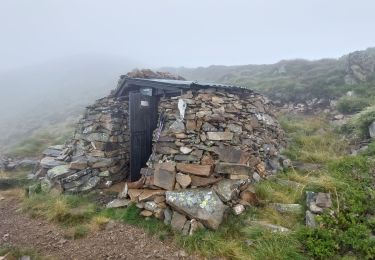
Station de ski , cabane de Campus, col de Soneres, col de l'Aouet ,Cap Nestes(1887m) et retour par les crêtes (brouillard intense toute la journée)
Localisation
Pays :
France
Région :
Occitanie
Département/Province :
Hautes-Pyrénées
Commune :
Sarrancolin
Localité :
Unknown
Départ:(Dec)
Départ:(UTM)
292504 ; 4757764 (31T) N.
Commentaires
Randonnées à proximité
![Randonnée Marche Ferrère - montagne d'Areng depuis la piste forestière après Férrères - Photo](https://media.geolcdn.com/t/375/260/b26d10b6-49f2-42a6-bd0e-42b976ea8679.jpg&format=jpg&maxdim=2)
![Marche Marche](https://static1.geolcdn.com/sitytour/trail-icons/101.png)
montagne d'Areng depuis la piste forestière après Férrères
Marche
Difficile
Ferrère,
Occitanie,
Hautes-Pyrénées,
France
![](/images/other/stat-length.png)
11,7 km | 24 km-effort
7h 44min
![](https://static1.geolcdn.com/siteimages/upload/files/16400158638029165_repeat_loop_refresh_sync_direction_icon.png)
Oui
![Randonnée Marche Sarrancolin - Mountarrouy en boucle depuis la station de Nistos - Photo](https://media.geolcdn.com/t/375/260/91730f02-00b8-4910-8950-1be3b401b416.jpg&format=jpg&maxdim=2)
![Marche Marche](https://static1.geolcdn.com/sitytour/trail-icons/101.png)
Mountarrouy en boucle depuis la station de Nistos
Marche
Moyen
Sarrancolin,
Occitanie,
Hautes-Pyrénées,
France
![](/images/other/stat-length.png)
10,8 km | 19,1 km-effort
5h 48min
![](https://static1.geolcdn.com/siteimages/upload/files/16400158638029165_repeat_loop_refresh_sync_direction_icon.png)
Oui
![Randonnée Marche Sarrancolin - nistos Nestea fait G4 - Photo](https://media.geolcdn.com/t/375/260/cedb4b5c-d7a1-493a-b2b1-455b86ff1a8b.jpg&format=jpg&maxdim=2)
![Marche Marche](https://static1.geolcdn.com/sitytour/trail-icons/101.png)
nistos Nestea fait G4
Marche
Très facile
Sarrancolin,
Occitanie,
Hautes-Pyrénées,
France
![](/images/other/stat-length.png)
7,4 km | 10,2 km-effort
4h 21min
![](https://static1.geolcdn.com/siteimages/upload/files/16400158638029165_repeat_loop_refresh_sync_direction_icon.png)
Oui
![Randonnée Marche Ferrère - Le Cournudère en boucle depuis Bordes de Saube - Photo](https://media.geolcdn.com/t/375/260/ext.jpg?maxdim=2&url=https%3A%2F%2Fservices.sitytrail.com%2FGeolivesWS%2FDownloadMedia.ashx%3FTrailID%3D754218%26Media%3Dfix__20170516124833.jpg)
![Marche Marche](https://static1.geolcdn.com/sitytour/trail-icons/101.png)
Le Cournudère en boucle depuis Bordes de Saube
Marche
Moyen
Ferrère,
Occitanie,
Hautes-Pyrénées,
France
![](/images/other/stat-length.png)
17,2 km | 34 km-effort
6h 35min
![](https://static1.geolcdn.com/siteimages/upload/files/16400158638029165_repeat_loop_refresh_sync_direction_icon.png)
Oui
![Randonnée Marche Sarrancolin - Cap Nestes - Photo](https://media.geolcdn.com/t/375/260/ext.jpg?maxdim=2&url=https%3A%2F%2Fservices.sitytrail.com%2FGeolivesWS%2FDownloadMedia.ashx%3FTrailID%3D109654%26Media%3D4295_5.jpg)
![Marche Marche](https://static1.geolcdn.com/sitytour/trail-icons/101.png)
Cap Nestes
Marche
Moyen
Sarrancolin,
Occitanie,
Hautes-Pyrénées,
France
![](/images/other/stat-length.png)
4 km | 7,7 km-effort
2h 10min
![](https://static1.geolcdn.com/siteimages/upload/files/16400158638029165_repeat_loop_refresh_sync_direction_icon.png)
Oui
![Randonnée Marche Nistos - NISTOS Cimetière Anglo-Canadien et pic de DOULY - Photo](https://media.geolcdn.com/t/375/260/ext.jpg?maxdim=2&url=https%3A%2F%2Fstatic1.geolcdn.com%2Fsiteimages%2Fupload%2Ffiles%2F1553511878bg_sport_marche.png)
![Marche Marche](https://static1.geolcdn.com/sitytour/trail-icons/101.png)
NISTOS Cimetière Anglo-Canadien et pic de DOULY
Marche
Difficile
Nistos,
Occitanie,
Hautes-Pyrénées,
France
![](/images/other/stat-length.png)
8,8 km | 14,9 km-effort
3h 23min
![](https://static1.geolcdn.com/siteimages/upload/files/16400158638029165_repeat_loop_refresh_sync_direction_icon.png)
Oui
![Randonnée Marche Ferrère - soum de templa - Photo](https://media.geolcdn.com/t/375/260/56aeb48b-18c0-4d72-a4b8-9250f7833f10.jpg&format=jpg&maxdim=2)
![Marche Marche](https://static1.geolcdn.com/sitytour/trail-icons/101.png)
soum de templa
Marche
Moyen
Ferrère,
Occitanie,
Hautes-Pyrénées,
France
![](/images/other/stat-length.png)
16,7 km | 32 km-effort
5h 21min
![](https://static1.geolcdn.com/siteimages/upload/files/16400158638029165_repeat_loop_refresh_sync_direction_icon.png)
Oui
![Randonnée Marche Ferrère - cap Nesté depuis la Barousse - Photo](https://media.geolcdn.com/t/375/260/ext.jpg?maxdim=2&url=https%3A%2F%2Fstatic1.geolcdn.com%2Fsiteimages%2Fupload%2Ffiles%2F1553511878bg_sport_marche.png)
![Marche Marche](https://static1.geolcdn.com/sitytour/trail-icons/101.png)
cap Nesté depuis la Barousse
Marche
Moyen
Ferrère,
Occitanie,
Hautes-Pyrénées,
France
![](/images/other/stat-length.png)
9,2 km | 19,3 km-effort
6h 46min
![](https://static1.geolcdn.com/siteimages/upload/files/16400158638029165_repeat_loop_refresh_sync_direction_icon.png)
Oui
![Randonnée Marche Nistos - 2016-10-08 Nistos - cimetière américain - Photo](https://media.geolcdn.com/t/375/260/ext.jpg?maxdim=2&url=https%3A%2F%2Fservices.sitytrail.com%2FGeolivesWS%2FDownloadMedia.ashx%3FTrailID%3D903798%26Media%3Dfix__20161008054052.jpg)
![Marche Marche](https://static1.geolcdn.com/sitytour/trail-icons/101.png)
2016-10-08 Nistos - cimetière américain
Marche
Facile
Nistos,
Occitanie,
Hautes-Pyrénées,
France
![](/images/other/stat-length.png)
6,3 km | 8,9 km-effort
2h 2min
![](https://static1.geolcdn.com/siteimages/upload/files/16400158638029165_repeat_loop_refresh_sync_direction_icon.png)
Oui