![](/images/other/stat-length.png)
![Randonnée A pied Pont-de-Veyle - Rando autour de Pont de Veyle - Photo](https://media.geolcdn.com/t/1900/400/ext.pjpeg?maxdim=2&url=https%3A%2F%2Fstatic1.geolcdn.com%2Fsiteimages%2Fupload%2Ffiles%2F1545311037marcheuse_200dpi.jpg)
Rando autour de Pont de Veyle
janussity
Utilisateur
![Longueur](/images/other/stat-length.png)
Longueur
11,8 km
![Altitude max](https://static1.geolcdn.com/siteimages/upload/files/1508320355ic_sort_altitude_max_24dp.png)
Altitude max
211 m
![Dénivelé positif](https://static1.geolcdn.com/siteimages/upload/files/1508320355ic_sort_den_pos_24dp.png)
Dénivelé positif
84 m
![Km-Effort](/images/other/stat-length.png)
Km-Effort
12,9 km
![Altitude min](https://static1.geolcdn.com/siteimages/upload/files/1508320355ic_sort_altitude_min_24dp.png)
Altitude min
171 m
![Dénivelé négatif](https://static1.geolcdn.com/siteimages/upload/files/1508320355ic_sort_den_neg_24dp.png)
Dénivelé négatif
84 m
![Boucle](https://static1.geolcdn.com/siteimages/upload/files/16400158638029165_repeat_loop_refresh_sync_direction_icon.png)
Boucle
Oui
Date de création :
2020-05-24 11:59:10.517
Dernière modification :
2020-05-24 12:02:23.226
![A pied](https://static1.geolcdn.com/sitytour/trail-icons/100.png)
--
Difficulté : Très facile
![Scannez ce code QR pour ouvrir la randonnée dans l'application SityTrail](https://capi.geolives.com/qq0zvz2zws4bq2lad0pu/sitytour/trails/2408780/qr.png?size=200)
Application GPS de randonnée GRATUITE
À propos
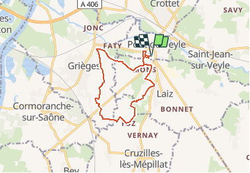
Randonnée A pied de 11,8 km à découvrir à Auvergne-Rhône-Alpes, Ain, Pont-de-Veyle. Cette randonnée est proposée par janussity.
Description
faite le 24 mai 2020 avec les Henri par temps ensoleillé agréable à 21°C.
PdV,Faty( Grièges) Courcelles, Foz, Laiz Malivert.
11.77 km
Localisation
Pays :
France
Région :
Auvergne-Rhône-Alpes
Département/Province :
Ain
Commune :
Pont-de-Veyle
Localité :
Unknown
Départ:(Dec)
Départ:(UTM)
645359 ; 5124560 (31T) N.
Commentaires
Randonnées à proximité
![Randonnée Marche Mâcon - Macon Cluny Chalon Macon 148km - Photo](https://media.geolcdn.com/t/375/260/a87f1fe2-8c9a-4575-aa8e-c461c2bdf882.jpg&format=jpg&maxdim=2)
![Marche Marche](https://static1.geolcdn.com/sitytour/trail-icons/101.png)
Macon Cluny Chalon Macon 148km
Marche
Moyen
Mâcon,
Bourgogne-Franche-Comté,
Saône-et-Loire,
France
![](/images/other/stat-length.png)
148 km | 165 km-effort
13h 44min
![](https://static1.geolcdn.com/siteimages/upload/files/16400158638029165_repeat_loop_refresh_sync_direction_icon.png)
Oui
![Randonnée Randonnée équestre Laiz - Bords de Saône. Version inondée - Photo](https://media.geolcdn.com/t/375/260/ext.jpg?maxdim=2&url=https%3A%2F%2Fstatic1.geolcdn.com%2Fsiteimages%2Fupload%2Ffiles%2F1524743154cheval.jpg)
![Randonnée équestre Randonnée équestre](https://static1.geolcdn.com/sitytour/trail-icons/301.png)
Bords de Saône. Version inondée
Randonnée équestre
Difficile
(1)
Laiz,
Auvergne-Rhône-Alpes,
Ain,
France
![](/images/other/stat-length.png)
31 km | 35 km-effort
4h 33min
![](https://static1.geolcdn.com/siteimages/upload/files/16400158638029165_repeat_loop_refresh_sync_direction_icon.png)
Oui
![Randonnée sport Replonges - 2023-12-17_13h47m13_retour_a_laiz-18080067-1702813386-845-1 - Photo](https://media.geolcdn.com/t/375/260/ext.jpg?maxdim=2&url=https%3A%2F%2Fsecurestorage.geolives.com%2Fsitytour%2Ftrail-bg%2Fdefault.jpg)
2023-12-17_13h47m13_retour_a_laiz-18080067-1702813386-845-1
sport
Très facile
(1)
Replonges,
Auvergne-Rhône-Alpes,
Ain,
France
![](/images/other/stat-length.png)
17,9 km | 19,8 km-effort
Inconnu
![](https://static1.geolcdn.com/siteimages/upload/files/16400158638029165_repeat_loop_refresh_sync_direction_icon.png)
Non
![Randonnée Vélo de route Cormoranche-sur-Saône - 01 voie verte et bleue macon - Photo](https://media.geolcdn.com/t/375/260/db10580d-accf-4352-a58c-c49df6817574.jpg&format=jpg&maxdim=2)
![Vélo de route Vélo de route](https://static1.geolcdn.com/sitytour/trail-icons/201.png)
01 voie verte et bleue macon
Vélo de route
Moyen
Cormoranche-sur-Saône,
Auvergne-Rhône-Alpes,
Ain,
France
![](/images/other/stat-length.png)
74 km | 84 km-effort
4h 45min
![](https://static1.geolcdn.com/siteimages/upload/files/16400158638029165_repeat_loop_refresh_sync_direction_icon.png)
Oui
![Randonnée A pied Mâcon - sejour-rcy-les-cretes-du-haut-beaujolais-visite-de-macon-et-retour-a-la-gare- - Photo](https://media.geolcdn.com/t/375/260/ext.jpg?maxdim=2&url=https%3A%2F%2Fstatic1.geolcdn.com%2Fsiteimages%2Fupload%2Ffiles%2F1545311037marcheuse_200dpi.jpg)
![A pied A pied](https://static1.geolcdn.com/sitytour/trail-icons/100.png)
sejour-rcy-les-cretes-du-haut-beaujolais-visite-de-macon-et-retour-a-la-gare-
A pied
Facile
Mâcon,
Bourgogne-Franche-Comté,
Saône-et-Loire,
France
![](/images/other/stat-length.png)
9 km | 10,2 km-effort
2h 18min
![](https://static1.geolcdn.com/siteimages/upload/files/16400158638029165_repeat_loop_refresh_sync_direction_icon.png)
Non
![Randonnée Marche Crottet - Ballade autour de CROTTET - Photo](https://media.geolcdn.com/t/375/260/ext.jpg?maxdim=2&url=https%3A%2F%2Fstatic1.geolcdn.com%2Fsiteimages%2Fupload%2Ffiles%2F1553511878bg_sport_marche.png)
![Marche Marche](https://static1.geolcdn.com/sitytour/trail-icons/101.png)
Ballade autour de CROTTET
Marche
Crottet,
Auvergne-Rhône-Alpes,
Ain,
France
![](/images/other/stat-length.png)
5,2 km | 5,7 km-effort
1h 21min
![](https://static1.geolcdn.com/siteimages/upload/files/16400158638029165_repeat_loop_refresh_sync_direction_icon.png)
Oui
![Randonnée V.T.T. Pont-de-Veyle - Ain et voie bleue - Photo](https://media.geolcdn.com/t/375/260/ext.jpg?maxdim=2&url=https%3A%2F%2Fstatic1.geolcdn.com%2Fsiteimages%2Fupload%2Ffiles%2F1524743154velo.jpg)
![V.T.T. V.T.T.](https://static1.geolcdn.com/sitytour/trail-icons/202.png)
Ain et voie bleue
V.T.T.
Moyen
Pont-de-Veyle,
Auvergne-Rhône-Alpes,
Ain,
France
![](/images/other/stat-length.png)
24 km | 26 km-effort
1h 43min
![](https://static1.geolcdn.com/siteimages/upload/files/16400158638029165_repeat_loop_refresh_sync_direction_icon.png)
Oui
![Randonnée Randonnée équestre Laiz - 2023-05-25_09h39m05_boucle_30_km_vonnas-7413273-1684955259-744 - Photo](https://media.geolcdn.com/t/375/260/ext.jpg?maxdim=2&url=https%3A%2F%2Fstatic1.geolcdn.com%2Fsiteimages%2Fupload%2Ffiles%2F1524743154cheval.jpg)
![Randonnée équestre Randonnée équestre](https://static1.geolcdn.com/sitytour/trail-icons/301.png)
2023-05-25_09h39m05_boucle_30_km_vonnas-7413273-1684955259-744
Randonnée équestre
Difficile
Laiz,
Auvergne-Rhône-Alpes,
Ain,
France
![](/images/other/stat-length.png)
29 km | 33 km-effort
4h 21min
![](https://static1.geolcdn.com/siteimages/upload/files/16400158638029165_repeat_loop_refresh_sync_direction_icon.png)
Oui
![Randonnée Randonnée équestre Laiz - 2023-05-25_09h38m20_laiz_vesines_34_km-16835074-1684955197-729 - Photo](https://media.geolcdn.com/t/375/260/ext.jpg?maxdim=2&url=https%3A%2F%2Fstatic1.geolcdn.com%2Fsiteimages%2Fupload%2Ffiles%2F1524743154cheval.jpg)
![Randonnée équestre Randonnée équestre](https://static1.geolcdn.com/sitytour/trail-icons/301.png)
2023-05-25_09h38m20_laiz_vesines_34_km-16835074-1684955197-729
Randonnée équestre
Difficile
(1)
Laiz,
Auvergne-Rhône-Alpes,
Ain,
France
![](/images/other/stat-length.png)
34 km | 38 km-effort
4h 57min
![](https://static1.geolcdn.com/siteimages/upload/files/16400158638029165_repeat_loop_refresh_sync_direction_icon.png)
Non