![](/images/other/stat-length.png)
![Randonnée A pied Ham-sur-Heure-Nalinnes - Promenade de Jamioulx - Photo](https://media.geolcdn.com/t/1900/400/df69fcdd-f8b5-43fb-ba99-e35268912805.jpg&format=pjpeg&maxdim=2)
Promenade de Jamioulx
Desrumaux
Utilisateur GUIDE
![Longueur](/images/other/stat-length.png)
Longueur
5,2 km
![Altitude max](https://static1.geolcdn.com/siteimages/upload/files/1508320355ic_sort_altitude_max_24dp.png)
Altitude max
213 m
![Dénivelé positif](https://static1.geolcdn.com/siteimages/upload/files/1508320355ic_sort_den_pos_24dp.png)
Dénivelé positif
121 m
![Km-Effort](/images/other/stat-length.png)
Km-Effort
6,8 km
![Altitude min](https://static1.geolcdn.com/siteimages/upload/files/1508320355ic_sort_altitude_min_24dp.png)
Altitude min
119 m
![Dénivelé négatif](https://static1.geolcdn.com/siteimages/upload/files/1508320355ic_sort_den_neg_24dp.png)
Dénivelé négatif
121 m
![Boucle](https://static1.geolcdn.com/siteimages/upload/files/16400158638029165_repeat_loop_refresh_sync_direction_icon.png)
Boucle
Oui
Date de création :
2020-05-11 19:42:51.848
Dernière modification :
2020-05-11 20:06:05.307
![A pied](https://static1.geolcdn.com/sitytour/trail-icons/100.png)
--
Difficulté : Très facile
![Scannez ce code QR pour ouvrir la randonnée dans l'application SityTrail](https://capi.geolives.com/qq0zvz2zws4bq2lad0pu/sitytour/trails/2394610/qr.png?size=200)
Application GPS de randonnée GRATUITE
À propos
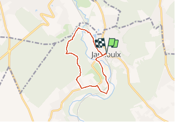
Randonnée A pied de 5,2 km à découvrir à Wallonie, Hainaut, Ham-sur-Heure-Nalinnes. Cette randonnée est proposée par Desrumaux.
Description
Jolie promenade proposée par l'office du tourisme de Ham-sur-heure - Nalinnes au départ du village de Jamioulx.
Balisage: losange rouge.
Localisation
Pays :
Belgique
Région :
Wallonie
Département/Province :
Hainaut
Commune :
Ham-sur-Heure-Nalinnes
Localité :
Jamioulx
Départ:(Dec)
Départ:(UTM)
600512 ; 5578825 (31U) N.
Commentaires
Randonnées à proximité
![Randonnée Marche Gerpinnes - La promenade des Lacs de Loverval - Photo](https://media.geolcdn.com/t/375/260/ext.jpg?maxdim=2&url=https%3A%2F%2Fstatic1.geolcdn.com%2Fsiteimages%2Fupload%2Ffiles%2F1553511878bg_sport_marche.png)
![Marche Marche](https://static1.geolcdn.com/sitytour/trail-icons/101.png)
La promenade des Lacs de Loverval
Marche
Facile
(7)
Gerpinnes,
Wallonie,
Hainaut,
Belgique
![](/images/other/stat-length.png)
8,5 km | 10,6 km-effort
2h 10min
![](https://static1.geolcdn.com/siteimages/upload/files/16400158638029165_repeat_loop_refresh_sync_direction_icon.png)
Oui
![Randonnée Marche Ham-sur-Heure-Nalinnes - Promenade dans le Bois Jacques - Photo](https://media.geolcdn.com/t/375/260/ext.jpg?maxdim=2&url=https%3A%2F%2Fstatic1.geolcdn.com%2Fsiteimages%2Fupload%2Ffiles%2F1553511878bg_sport_marche.png)
![Marche Marche](https://static1.geolcdn.com/sitytour/trail-icons/101.png)
Promenade dans le Bois Jacques
Marche
Très facile
(8)
Ham-sur-Heure-Nalinnes,
Wallonie,
Hainaut,
Belgique
![](/images/other/stat-length.png)
3,5 km | 4,7 km-effort
1h 0min
![](https://static1.geolcdn.com/siteimages/upload/files/16400158638029165_repeat_loop_refresh_sync_direction_icon.png)
Oui
![Randonnée Marche Montigny-le-Tilleul - A la découverte des sentes et venelles de Montigny-le-Tilleul - Photo](https://media.geolcdn.com/t/375/260/ext.jpg?maxdim=2&url=https%3A%2F%2Fstatic1.geolcdn.com%2Fsiteimages%2Fupload%2Ffiles%2F1553511878bg_sport_marche.png)
![Marche Marche](https://static1.geolcdn.com/sitytour/trail-icons/101.png)
A la découverte des sentes et venelles de Montigny-le-Tilleul
Marche
Facile
(6)
Montigny-le-Tilleul,
Wallonie,
Hainaut,
Belgique
![](/images/other/stat-length.png)
7,8 km | 9,9 km-effort
2h 0min
![](https://static1.geolcdn.com/siteimages/upload/files/16400158638029165_repeat_loop_refresh_sync_direction_icon.png)
Oui
![Randonnée Marche Montigny-le-Tilleul - Balade en Val de Sambre - De Landelies à l'Abbaye d'Aulne - Photo](https://media.geolcdn.com/t/375/260/ext.jpg?maxdim=2&url=https%3A%2F%2Fservices.sitytrail.com%2FGeolivesWS%2FDownloadMedia.ashx%3FTrailID%3D498562%26Media%3D0c817a37-45f6-4c22-ab94-a572de965186.JPG)
![Marche Marche](https://static1.geolcdn.com/sitytour/trail-icons/101.png)
Balade en Val de Sambre - De Landelies à l'Abbaye d'Aulne
Marche
Très facile
(1)
Montigny-le-Tilleul,
Wallonie,
Hainaut,
Belgique
![](/images/other/stat-length.png)
6,6 km | 8 km-effort
1h 49min
![](https://static1.geolcdn.com/siteimages/upload/files/16400158638029165_repeat_loop_refresh_sync_direction_icon.png)
Oui
![Marche Marche](https://static1.geolcdn.com/sitytour/trail-icons/101.png)
BE-Montigny-le-Tilleul - Landelies - Aulne - 2
Marche
Très facile
(1)
Montigny-le-Tilleul,
Wallonie,
Hainaut,
Belgique
![](/images/other/stat-length.png)
7,1 km | 9,6 km-effort
2h 4min
![](https://static1.geolcdn.com/siteimages/upload/files/16400158638029165_repeat_loop_refresh_sync_direction_icon.png)
Oui
![Randonnée Marche Ham-sur-Heure-Nalinnes - Balade printanière à Ham-sur-Heure - Photo](https://media.geolcdn.com/t/375/260/ext.jpg?maxdim=2&url=https%3A%2F%2Fservices.sitytrail.com%2FGeolivesWS%2FDownloadMedia.ashx%3FTrailID%3D186510%26Media%3Ddd080f12-76d1-45e7-9821-4f87e3881262.JPG)
![Marche Marche](https://static1.geolcdn.com/sitytour/trail-icons/101.png)
Balade printanière à Ham-sur-Heure
Marche
Facile
(1)
Ham-sur-Heure-Nalinnes,
Wallonie,
Hainaut,
Belgique
![](/images/other/stat-length.png)
11,5 km | 14,5 km-effort
3h 7min
![](https://static1.geolcdn.com/siteimages/upload/files/16400158638029165_repeat_loop_refresh_sync_direction_icon.png)
Oui
![Randonnée Marche Charleroi - RB-Ha-06 - Bois du Cazier - Photo](https://media.geolcdn.com/t/375/260/ext.jpg?maxdim=2&url=https%3A%2F%2Fservices.sitytrail.com%2FGeolivesWS%2FDownloadMedia.ashx%3FTrailID%3D179599%26Media%3D2837e250-a032-4aff-9766-ede65c270e46.jpg)
![Marche Marche](https://static1.geolcdn.com/sitytour/trail-icons/101.png)
RB-Ha-06 - Bois du Cazier
Marche
Très difficile
(4)
Charleroi,
Wallonie,
Hainaut,
Belgique
![](/images/other/stat-length.png)
21 km | 26 km-effort
5h 58min
![](https://static1.geolcdn.com/siteimages/upload/files/16400158638029165_repeat_loop_refresh_sync_direction_icon.png)
Oui
![Randonnée Marche Ham-sur-Heure-Nalinnes - Balade en forêt à Ham-sur-Heure - Photo](https://media.geolcdn.com/t/375/260/ext.jpg?maxdim=2&url=https%3A%2F%2Fservices.sitytrail.com%2FGeolivesWS%2FDownloadMedia.ashx%3FTrailID%3D107876%26Media%3Da9fb6354-3acc-4c81-b9e0-1c56fd4c8076.jpg)
![Marche Marche](https://static1.geolcdn.com/sitytour/trail-icons/101.png)
Balade en forêt à Ham-sur-Heure
Marche
Facile
(2)
Ham-sur-Heure-Nalinnes,
Wallonie,
Hainaut,
Belgique
![](/images/other/stat-length.png)
5,7 km | 7,1 km-effort
1h 30min
![](https://static1.geolcdn.com/siteimages/upload/files/16400158638029165_repeat_loop_refresh_sync_direction_icon.png)
Oui
![Randonnée Marche Ham-sur-Heure-Nalinnes - Balade en forêt à Ham-sur-Heure - Photo](https://media.geolcdn.com/t/375/260/ext.jpg?maxdim=2&url=https%3A%2F%2Fstatic1.geolcdn.com%2Fsiteimages%2Fupload%2Ffiles%2F1553511878bg_sport_marche.png)
![Marche Marche](https://static1.geolcdn.com/sitytour/trail-icons/101.png)
Balade en forêt à Ham-sur-Heure
Marche
Moyen
(1)
Ham-sur-Heure-Nalinnes,
Wallonie,
Hainaut,
Belgique
![](/images/other/stat-length.png)
9 km | 11 km-effort
2h 23min
![](https://static1.geolcdn.com/siteimages/upload/files/16400158638029165_repeat_loop_refresh_sync_direction_icon.png)
Oui