![](/images/other/stat-length.png)
![Randonnée Autre activité Zernez - Nationalpark: Margunet - Photo](https://media.geolcdn.com/t/1900/400/ext.pjpeg?maxdim=2&url=https%3A%2F%2Fstatic1.geolcdn.com%2Fsiteimages%2Fupload%2Ffiles%2F1545311037marcheuse_200dpi.jpg)
Nationalpark: Margunet
bffcuc
Utilisateur
![Longueur](/images/other/stat-length.png)
![Altitude max](https://static1.geolcdn.com/siteimages/upload/files/1508320355ic_sort_altitude_max_24dp.png)
![Dénivelé positif](https://static1.geolcdn.com/siteimages/upload/files/1508320355ic_sort_den_pos_24dp.png)
![Km-Effort](/images/other/stat-length.png)
![Altitude min](https://static1.geolcdn.com/siteimages/upload/files/1508320355ic_sort_altitude_min_24dp.png)
![Dénivelé négatif](https://static1.geolcdn.com/siteimages/upload/files/1508320355ic_sort_den_neg_24dp.png)
![Boucle](https://static1.geolcdn.com/siteimages/upload/files/16400158638029165_repeat_loop_refresh_sync_direction_icon.png)
![Autre activité](https://static1.geolcdn.com/sitytour/trail-icons/900.png)
--
Difficulté : Inconnu
![Scannez ce code QR pour ouvrir la randonnée dans l'application SityTrail](https://capi.geolives.com/qq0zvz2zws4bq2lad0pu/sitytour/trails/23889/qr.png?size=200)
Application GPS de randonnée GRATUITE
À propos
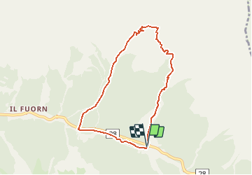
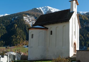
Randonnée Autre activité de 7,1 km à découvrir à Grisons, Region Engiadina Bassa/Val Müstair, Zernez. Cette randonnée est proposée par bffcuc.
Description
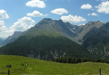
Anstrengende aber grossartige Tour duch den Nationalpark.
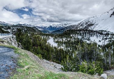
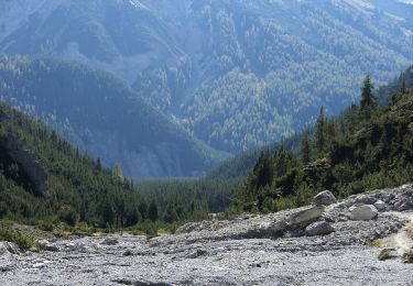
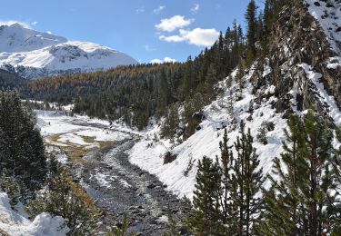
Von Buffalora aus steigt man an den alten Eisenerzminen vorbei zum Nationalpark auf. Danach verläft die Route auf gut 2''300 Metern Höhe richtung Munt la Schera. Gämsen und Murmeltiere können beobachtet werden. Danach steigt man zum Plateau des Munt la Schera hoch, von wo man eine grossartige Aussicht hat. Danach gehts runter auf die Alp la Schera und weiter Richtung Spölschlucht. Kurz vor der Staumauer zweigt man rechts ab und überquert die Spöl. Dann folgt man hoch über dem FLuss dem Verlauf der Schlucht bis man auf den Fussweg der vom Munter herunterommt trifft. Hier überquert man die Spöl erneut, traversiert dann die Ofenpasstrasse und wandert durch einen schönen Bergwald hoch zur Alp Grumells. Von her hat man einen wunderbaren Ausblick ins Fuorn-Tal. Danach geht es runter nach Il Fuorn. Hier gibt es ein Hotel, es ist die einzige Verpflegungsmöglichkeit während der ganzen Wanderung. Dnach folgt man dem Fuorntal hoch in zurück nach Buffalora. Dieser Teil der Wanderung ist nicht mehr sonderlich attraktiv. Wer will kann auch das Postauto nehmen.
Localisation
Commentaires
Randonnées à proximité
![Randonnée A pied Val Müstair - Pass dal Fuorn - Süsom Tschierv - Photo](https://media.geolcdn.com/t/375/260/1c1847b4-9881-4989-8b2a-3faf354498ca.jpeg&format=jpg&maxdim=2)
![A pied A pied](https://static1.geolcdn.com/sitytour/trail-icons/100.png)
A pied
![](/images/other/stat-length.png)
![](https://static1.geolcdn.com/siteimages/upload/files/16400158638029165_repeat_loop_refresh_sync_direction_icon.png)
![Randonnée A pied Zernez - Nationalpark Wanderroute 16 (Fuorntal) - Photo](https://media.geolcdn.com/t/375/260/dev_b47906a4-0a0c-47a9-8e95-628ca5757862.jpeg&format=jpg&maxdim=2)
![A pied A pied](https://static1.geolcdn.com/sitytour/trail-icons/100.png)
A pied
![](/images/other/stat-length.png)
![](https://static1.geolcdn.com/siteimages/upload/files/16400158638029165_repeat_loop_refresh_sync_direction_icon.png)
![Randonnée A pied Zernez - P7 - Margunet - Stabelchod - P8 - P7 - Photo](https://media.geolcdn.com/t/375/260/83a8d9bc-4994-4e4a-92b2-11a43b17ba43.jpeg&format=jpg&maxdim=2)
![A pied A pied](https://static1.geolcdn.com/sitytour/trail-icons/100.png)
A pied
![](/images/other/stat-length.png)
![](https://static1.geolcdn.com/siteimages/upload/files/16400158638029165_repeat_loop_refresh_sync_direction_icon.png)
![Randonnée A pied Val Müstair - Pass dal Fuorn - Funtana da S-charl - Photo](https://media.geolcdn.com/t/375/260/1c1847b4-9881-4989-8b2a-3faf354498ca.jpeg&format=jpg&maxdim=2)
![A pied A pied](https://static1.geolcdn.com/sitytour/trail-icons/100.png)
A pied
![](/images/other/stat-length.png)
![](https://static1.geolcdn.com/siteimages/upload/files/16400158638029165_repeat_loop_refresh_sync_direction_icon.png)
![Randonnée A pied Zernez - Punt dal Gal - Punt la Drossa - Photo](https://media.geolcdn.com/t/375/260/b5a85f00-7869-4b1d-bb20-90c2864a66f0.jpeg&format=jpg&maxdim=2)
![A pied A pied](https://static1.geolcdn.com/sitytour/trail-icons/100.png)
A pied
![](/images/other/stat-length.png)
![](https://static1.geolcdn.com/siteimages/upload/files/16400158638029165_repeat_loop_refresh_sync_direction_icon.png)
![Randonnée A pied Zernez - Nationalpark Wanderroute 13 (Champlönch) - Photo](https://media.geolcdn.com/t/375/260/7214e2c0-1b5b-4610-beb4-b5246d065ea1.jpeg&format=jpg&maxdim=2)
![A pied A pied](https://static1.geolcdn.com/sitytour/trail-icons/100.png)
A pied
![](/images/other/stat-length.png)
![](https://static1.geolcdn.com/siteimages/upload/files/16400158638029165_repeat_loop_refresh_sync_direction_icon.png)
![Randonnée A pied Val Müstair - Senda Val Müstair - Photo](https://media.geolcdn.com/t/375/260/419c8827-1fc3-4c1d-9913-a37cf7a2102f.jpeg&format=jpg&maxdim=2)
![A pied A pied](https://static1.geolcdn.com/sitytour/trail-icons/100.png)
A pied
![](/images/other/stat-length.png)
![](https://static1.geolcdn.com/siteimages/upload/files/16400158638029165_repeat_loop_refresh_sync_direction_icon.png)
![Randonnée A pied Val Müstair - Nationalpark Wanderroute 15 (Munt la Schera) - Photo](https://media.geolcdn.com/t/375/260/dev_a970fcb7-0ab6-49e0-9e68-48c02f68ec84.jpeg&format=jpg&maxdim=2)
![A pied A pied](https://static1.geolcdn.com/sitytour/trail-icons/100.png)
A pied
![](/images/other/stat-length.png)
![](https://static1.geolcdn.com/siteimages/upload/files/16400158638029165_repeat_loop_refresh_sync_direction_icon.png)