![](/images/other/stat-length.png)
![Randonnée Marche Plédran - Tour du bourg de Pledran. circuit 1. - Photo](https://media.geolcdn.com/t/1900/400/ext.pjpeg?maxdim=2&url=https%3A%2F%2Fstatic1.geolcdn.com%2Fsiteimages%2Fupload%2Ffiles%2F1553511878bg_sport_marche.png)
Tour du bourg de Pledran. circuit 1.
Alphe
Utilisateur
![Longueur](/images/other/stat-length.png)
Longueur
6,9 km
![Altitude max](https://static1.geolcdn.com/siteimages/upload/files/1508320355ic_sort_altitude_max_24dp.png)
Altitude max
169 m
![Dénivelé positif](https://static1.geolcdn.com/siteimages/upload/files/1508320355ic_sort_den_pos_24dp.png)
Dénivelé positif
73 m
![Km-Effort](/images/other/stat-length.png)
Km-Effort
7,9 km
![Altitude min](https://static1.geolcdn.com/siteimages/upload/files/1508320355ic_sort_altitude_min_24dp.png)
Altitude min
124 m
![Dénivelé négatif](https://static1.geolcdn.com/siteimages/upload/files/1508320355ic_sort_den_neg_24dp.png)
Dénivelé négatif
75 m
![Boucle](https://static1.geolcdn.com/siteimages/upload/files/16400158638029165_repeat_loop_refresh_sync_direction_icon.png)
Boucle
Oui
Date de création :
2020-05-01 14:05:47.77
Dernière modification :
2020-05-01 16:07:56.42
![Marche](https://static1.geolcdn.com/sitytour/trail-icons/101.png)
1h38
Difficulté : Très facile
![Scannez ce code QR pour ouvrir la randonnée dans l'application SityTrail](https://capi.geolives.com/qq0zvz2zws4bq2lad0pu/sitytour/trails/2388821/qr.png?size=200)
Application GPS de randonnée GRATUITE
À propos
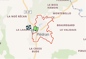
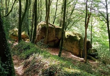
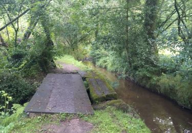
Randonnée Marche de 6,9 km à découvrir à Bretagne, Côtes-d'Armor, Plédran. Cette randonnée est proposée par Alphe.
Description
Rue du Challenge, le bourg, la Belle issue, le Tertre du bourg,la Motte, rue du Val, Carbloux, le Pesle Châtel, Villeneuve, rue du Haut Chemin , le Challenge.
Localisation
Pays :
France
Région :
Bretagne
Département/Province :
Côtes-d'Armor
Commune :
Plédran
Localité :
Unknown
Départ:(Dec)
Départ:(UTM)
518525 ; 5365626 (30U) N.
Commentaires
Randonnées à proximité
![Randonnée Marche Plédran - En suivant l'URNE et en passant par le BOIS. - Photo](https://media.geolcdn.com/t/375/260/6ac5e845-12d0-4dac-9210-e8525380a84b.jpg&format=jpg&maxdim=2)
![Marche Marche](https://static1.geolcdn.com/sitytour/trail-icons/101.png)
En suivant l'URNE et en passant par le BOIS.
Marche
Moyen
(1)
Plédran,
Bretagne,
Côtes-d'Armor,
France
![](/images/other/stat-length.png)
15,2 km | 18 km-effort
2h 16min
![](https://static1.geolcdn.com/siteimages/upload/files/16400158638029165_repeat_loop_refresh_sync_direction_icon.png)
Oui
![Randonnée Cyclotourisme Saint-Carreuc - 4 étapes en Bretagne à vélo - Photo](https://media.geolcdn.com/t/375/260/b73d1ea1-a210-439a-a2e4-05e8d782bfa8.jpg&format=jpg&maxdim=2)
![Cyclotourisme Cyclotourisme](https://static1.geolcdn.com/sitytour/trail-icons/204.png)
4 étapes en Bretagne à vélo
Cyclotourisme
Moyen
Saint-Carreuc,
Bretagne,
Côtes-d'Armor,
France
![](/images/other/stat-length.png)
172 km | 200 km-effort
16h 10min
![](https://static1.geolcdn.com/siteimages/upload/files/16400158638029165_repeat_loop_refresh_sync_direction_icon.png)
Non
![Randonnée Marche Plaintel - Au bois des Mauriers. N 2 - Photo](https://media.geolcdn.com/t/375/260/fbcf397a-65ed-44d6-9dc4-de1ae1163b15.jpg&format=jpg&maxdim=2)
![Marche Marche](https://static1.geolcdn.com/sitytour/trail-icons/101.png)
Au bois des Mauriers. N 2
Marche
Moyen
Plaintel,
Bretagne,
Côtes-d'Armor,
France
![](/images/other/stat-length.png)
6,5 km | 8,1 km-effort
1h 55min
![](https://static1.geolcdn.com/siteimages/upload/files/16400158638029165_repeat_loop_refresh_sync_direction_icon.png)
Oui
![Randonnée Marche Plaintel - Les Mauriers par le chemin des fées. - Photo](https://media.geolcdn.com/t/375/260/dbc16f7f-f074-4434-9af8-4cba226f873f.jpg&format=jpg&maxdim=2)
![Marche Marche](https://static1.geolcdn.com/sitytour/trail-icons/101.png)
Les Mauriers par le chemin des fées.
Marche
Très facile
Plaintel,
Bretagne,
Côtes-d'Armor,
France
![](/images/other/stat-length.png)
3,3 km | 4,6 km-effort
1h 3min
![](https://static1.geolcdn.com/siteimages/upload/files/16400158638029165_repeat_loop_refresh_sync_direction_icon.png)
Oui
![Randonnée Course à pied Saint-Carreuc - la ville mereuc 1 - Photo](https://media.geolcdn.com/t/375/260/3ad00373-fe78-4964-915b-6e653e4b8a92.jpg&format=jpg&maxdim=2)
![Course à pied Course à pied](https://static1.geolcdn.com/sitytour/trail-icons/103.png)
la ville mereuc 1
Course à pied
Très facile
Saint-Carreuc,
Bretagne,
Côtes-d'Armor,
France
![](/images/other/stat-length.png)
9 km | 11,1 km-effort
58min
![](https://static1.geolcdn.com/siteimages/upload/files/16400158638029165_repeat_loop_refresh_sync_direction_icon.png)
Oui
![Randonnée Marche Ploufragan - Les vallées - Photo](https://media.geolcdn.com/t/375/260/ext.jpg?maxdim=2&url=https%3A%2F%2Fstatic1.geolcdn.com%2Fsiteimages%2Fupload%2Ffiles%2F1553511878bg_sport_marche.png)
![Marche Marche](https://static1.geolcdn.com/sitytour/trail-icons/101.png)
Les vallées
Marche
Très facile
Ploufragan,
Bretagne,
Côtes-d'Armor,
France
![](/images/other/stat-length.png)
9,2 km | 10,3 km-effort
1h 56min
![](https://static1.geolcdn.com/siteimages/upload/files/16400158638029165_repeat_loop_refresh_sync_direction_icon.png)
Oui
![Randonnée Marche Saint-Julien - Découverte en bois de St- Julien. - Photo](https://media.geolcdn.com/t/375/260/ext.jpg?maxdim=2&url=https%3A%2F%2Fstatic1.geolcdn.com%2Fsiteimages%2Fupload%2Ffiles%2F1553511878bg_sport_marche.png)
![Marche Marche](https://static1.geolcdn.com/sitytour/trail-icons/101.png)
Découverte en bois de St- Julien.
Marche
Moyen
Saint-Julien,
Bretagne,
Côtes-d'Armor,
France
![](/images/other/stat-length.png)
5,1 km | 6,3 km-effort
1h 6min
![](https://static1.geolcdn.com/siteimages/upload/files/16400158638029165_repeat_loop_refresh_sync_direction_icon.png)
Oui
![Randonnée Marche Plédran - Entre histoire, fil de l'eau et forêt. - Photo](https://media.geolcdn.com/t/375/260/ext.jpg?maxdim=2&url=https%3A%2F%2Fstatic1.geolcdn.com%2Fsiteimages%2Fupload%2Ffiles%2F1553511878bg_sport_marche.png)
![Marche Marche](https://static1.geolcdn.com/sitytour/trail-icons/101.png)
Entre histoire, fil de l'eau et forêt.
Marche
Très facile
Plédran,
Bretagne,
Côtes-d'Armor,
France
![](/images/other/stat-length.png)
12,3 km | 15 km-effort
2h 21min
![](https://static1.geolcdn.com/siteimages/upload/files/16400158638029165_repeat_loop_refresh_sync_direction_icon.png)
Oui
![Randonnée Marche Plédran - Bourg de Pledran vers Piruit et retour - Photo](https://media.geolcdn.com/t/375/260/ext.jpg?maxdim=2&url=https%3A%2F%2Fstatic1.geolcdn.com%2Fsiteimages%2Fupload%2Ffiles%2F1553511878bg_sport_marche.png)
![Marche Marche](https://static1.geolcdn.com/sitytour/trail-icons/101.png)
Bourg de Pledran vers Piruit et retour
Marche
Très facile
Plédran,
Bretagne,
Côtes-d'Armor,
France
![](/images/other/stat-length.png)
7,6 km | 9 km-effort
1h 45min
![](https://static1.geolcdn.com/siteimages/upload/files/16400158638029165_repeat_loop_refresh_sync_direction_icon.png)
Oui