![](/images/other/stat-length.png)
![Randonnée Autre activité Simplon - Simplon (CH) - Alpe Veglia (I) - Crampiolo (I) - Im Fäld (Binn) - Photo](https://media.geolcdn.com/t/1900/400/ext.pjpeg?maxdim=2&url=https%3A%2F%2Fstatic1.geolcdn.com%2Fsiteimages%2Fupload%2Ffiles%2F1545311037marcheuse_200dpi.jpg)
Simplon (CH) - Alpe Veglia (I) - Crampiolo (I) - Im Fäld (Binn)
Allegro
Utilisateur
![Longueur](/images/other/stat-length.png)
![Altitude max](https://static1.geolcdn.com/siteimages/upload/files/1508320355ic_sort_altitude_max_24dp.png)
![Dénivelé positif](https://static1.geolcdn.com/siteimages/upload/files/1508320355ic_sort_den_pos_24dp.png)
![Km-Effort](/images/other/stat-length.png)
![Altitude min](https://static1.geolcdn.com/siteimages/upload/files/1508320355ic_sort_altitude_min_24dp.png)
![Dénivelé négatif](https://static1.geolcdn.com/siteimages/upload/files/1508320355ic_sort_den_neg_24dp.png)
![Boucle](https://static1.geolcdn.com/siteimages/upload/files/16400158638029165_repeat_loop_refresh_sync_direction_icon.png)
![Autre activité](https://static1.geolcdn.com/sitytour/trail-icons/900.png)
--
Difficulté : Inconnu
![Scannez ce code QR pour ouvrir la randonnée dans l'application SityTrail](https://capi.geolives.com/qq0zvz2zws4bq2lad0pu/sitytour/trails/23844/qr.png?size=200)
Application GPS de randonnée GRATUITE
À propos
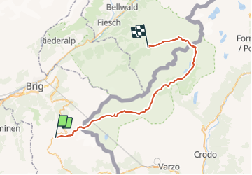
Randonnée Autre activité de 41 km à découvrir à Valais, Brigue, Simplon. Cette randonnée est proposée par Allegro.
Description
Pour découvrir le parcours, je vous invite à vous tendre sur le site http://home.citycable.ch/allegro.
Suivre ensuite le lien "42 KM POUR MES 40 ANS".
Hébergement et restauration :
http://www.eicn.ch/sommartel/cabane.htm
http://www.alpeveglia.it/fonte/index.htm
http://www.alpedevero.it/it/ospitalita-labaita-descrizione.htm
http://www.vs-wallis.ch/wallis/huetten/binntal.html
Localisation
Commentaires
Randonnées à proximité
![Randonnée A pied Simplon - Simplonpass-Simplon Dorf - Photo](https://media.geolcdn.com/t/375/260/312678fc-38b2-4e79-ae72-659ab7e3170c.jpeg&format=jpg&maxdim=2)
![A pied A pied](https://static1.geolcdn.com/sitytour/trail-icons/100.png)
A pied
![](/images/other/stat-length.png)
![](https://static1.geolcdn.com/siteimages/upload/files/16400158638029165_repeat_loop_refresh_sync_direction_icon.png)
![Randonnée A pied Visperterminen - Bistinenpass-Simplonpass - Photo](https://media.geolcdn.com/t/375/260/312678fc-38b2-4e79-ae72-659ab7e3170c.jpeg&format=jpg&maxdim=2)
![A pied A pied](https://static1.geolcdn.com/sitytour/trail-icons/100.png)
A pied
![](/images/other/stat-length.png)
![](https://static1.geolcdn.com/siteimages/upload/files/16400158638029165_repeat_loop_refresh_sync_direction_icon.png)
![Randonnée Marche Simplon - Refuge Monté Leone - Photo](https://media.geolcdn.com/t/375/260/ff563d2e-b2d4-4ead-b66d-c0c119bcf083.jpg&format=jpg&maxdim=2)
![Marche Marche](https://static1.geolcdn.com/sitytour/trail-icons/101.png)
Marche
![](/images/other/stat-length.png)
![](https://static1.geolcdn.com/siteimages/upload/files/16400158638029165_repeat_loop_refresh_sync_direction_icon.png)
![Randonnée A pied Simplon - Rundweg Simplon-Bergalpe - Photo](https://media.geolcdn.com/t/375/260/7befdbaa-aae6-40f2-a58f-ac369b153e7a.jpeg&format=jpg&maxdim=2)
![A pied A pied](https://static1.geolcdn.com/sitytour/trail-icons/100.png)
A pied
![](/images/other/stat-length.png)
![](https://static1.geolcdn.com/siteimages/upload/files/16400158638029165_repeat_loop_refresh_sync_direction_icon.png)
![Randonnée Marche Simplon - Auf historischen Wegen im Simplongebiet - Photo](https://media.geolcdn.com/t/375/260/ext.jpg?maxdim=2&url=https%3A%2F%2Fstatic1.geolcdn.com%2Fsiteimages%2Fupload%2Ffiles%2F1553511878bg_sport_marche.png)
![Marche Marche](https://static1.geolcdn.com/sitytour/trail-icons/101.png)
Marche
![](/images/other/stat-length.png)
![](https://static1.geolcdn.com/siteimages/upload/files/16400158638029165_repeat_loop_refresh_sync_direction_icon.png)
![Randonnée Marche Simplon - walser_08 - Photo](https://media.geolcdn.com/t/375/260/ext.jpg?maxdim=2&url=https%3A%2F%2Fstatic1.geolcdn.com%2Fsiteimages%2Fupload%2Ffiles%2F1553511878bg_sport_marche.png)
![Marche Marche](https://static1.geolcdn.com/sitytour/trail-icons/101.png)
![Randonnée Ski de randonnée Ried-Brig - Hochtour Wasenalp - Photo](https://media.geolcdn.com/t/375/260/ext.jpg?maxdim=2&url=https%3A%2F%2Fstatic1.geolcdn.com%2Fsiteimages%2Fupload%2Ffiles%2F1524743154ski_fond.jpg)
![Ski de randonnée Ski de randonnée](https://static1.geolcdn.com/sitytour/trail-icons/503.png)
Ski de randonnée
![](/images/other/stat-length.png)
![](https://static1.geolcdn.com/siteimages/upload/files/16400158638029165_repeat_loop_refresh_sync_direction_icon.png)
![Randonnée Marche nordique Simplon - Court de Bard + Punta Fétita - Photo](https://media.geolcdn.com/t/375/260/ext.jpg?maxdim=2&url=https%3A%2F%2Fstatic1.geolcdn.com%2Fsiteimages%2Fupload%2Ffiles%2F1545311037marcheuse_200dpi.jpg)
![Marche nordique Marche nordique](https://static1.geolcdn.com/sitytour/trail-icons/102.png)
Marche nordique
![](/images/other/stat-length.png)
![](https://static1.geolcdn.com/siteimages/upload/files/16400158638029165_repeat_loop_refresh_sync_direction_icon.png)
![Randonnée Autre activité Simplon - Simplon - Visperterminen - Photo](https://media.geolcdn.com/t/375/260/ext.jpg?maxdim=2&url=https%3A%2F%2Fstatic1.geolcdn.com%2Fsiteimages%2Fupload%2Ffiles%2F1545311037marcheuse_200dpi.jpg)
![Autre activité Autre activité](https://static1.geolcdn.com/sitytour/trail-icons/900.png)
Autre activité
![](/images/other/stat-length.png)
![](https://static1.geolcdn.com/siteimages/upload/files/16400158638029165_repeat_loop_refresh_sync_direction_icon.png)