![](/images/other/stat-length.png)
![Randonnée A pied Bois-le-Roi - De Bois le Roi à Fontainebleau - Photo](https://media.geolcdn.com/t/1900/400/ext.pjpeg?maxdim=2&url=https%3A%2F%2Fstatic1.geolcdn.com%2Fsiteimages%2Fupload%2Ffiles%2F1545311037marcheuse_200dpi.jpg)
De Bois le Roi à Fontainebleau
jpcccb
Utilisateur
![Longueur](/images/other/stat-length.png)
Longueur
16,9 km
![Altitude max](https://static1.geolcdn.com/siteimages/upload/files/1508320355ic_sort_altitude_max_24dp.png)
Altitude max
156 m
![Dénivelé positif](https://static1.geolcdn.com/siteimages/upload/files/1508320355ic_sort_den_pos_24dp.png)
Dénivelé positif
249 m
![Km-Effort](/images/other/stat-length.png)
Km-Effort
20 km
![Altitude min](https://static1.geolcdn.com/siteimages/upload/files/1508320355ic_sort_altitude_min_24dp.png)
Altitude min
78 m
![Dénivelé négatif](https://static1.geolcdn.com/siteimages/upload/files/1508320355ic_sort_den_neg_24dp.png)
Dénivelé négatif
247 m
![Boucle](https://static1.geolcdn.com/siteimages/upload/files/16400158638029165_repeat_loop_refresh_sync_direction_icon.png)
Boucle
Non
Date de création :
2020-04-18 12:18:32.802
Dernière modification :
2023-06-18 14:31:19.101
![A pied](https://static1.geolcdn.com/sitytour/trail-icons/100.png)
4h35
Difficulté : Moyen
![Scannez ce code QR pour ouvrir la randonnée dans l'application SityTrail](https://capi.geolives.com/qq0zvz2zws4bq2lad0pu/sitytour/trails/2382072/qr.png?size=200)
Application GPS de randonnée GRATUITE
À propos
Randonnée A pied de 16,9 km à découvrir à Île-de-France, Seine-et-Marne, Bois-le-Roi. Cette randonnée est proposée par jpcccb.
Description
GR 1 TMF, GR 1 E, carrefour des longues vallées, grotte aux cristaux, route des hauteurs de la Solle, route du nid d'aigle, caverne d'Augas.
Localisation
Pays :
France
Région :
Île-de-France
Département/Province :
Seine-et-Marne
Commune :
Bois-le-Roi
Localité :
Unknown
Départ:(Dec)
Départ:(UTM)
477241 ; 5369187 (31U) N.
Commentaires
Randonnées à proximité
![Randonnée Marche Fontainebleau - Sur les traces de Césaire Sempité - Fontainebleau rocher canon - Photo](https://media.geolcdn.com/t/375/260/b9aa5b48-fd03-4263-8213-67fa0706433b.jpg&format=jpg&maxdim=2)
![Marche Marche](https://static1.geolcdn.com/sitytour/trail-icons/101.png)
Sur les traces de Césaire Sempité - Fontainebleau rocher canon
Marche
Facile
(1)
Fontainebleau,
Île-de-France,
Seine-et-Marne,
France
![](/images/other/stat-length.png)
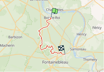
17,3 km | 21 km-effort
4h 8min
![](https://static1.geolcdn.com/siteimages/upload/files/16400158638029165_repeat_loop_refresh_sync_direction_icon.png)
Oui
![Randonnée Marche Bois-le-Roi - 170822 - RECO BoisLeRoi-Cmcas - Photo](https://media.geolcdn.com/t/375/260/ext.jpg?maxdim=2&url=https%3A%2F%2Fservices.sitytrail.com%2FGeolivesWS%2FDownloadMedia.ashx%3FTrailID%3D815573%26Media%3Dfix__20170822110103.jpg)
![Marche Marche](https://static1.geolcdn.com/sitytour/trail-icons/101.png)
170822 - RECO BoisLeRoi-Cmcas
Marche
Très facile
(1)
Bois-le-Roi,
Île-de-France,
Seine-et-Marne,
France
![](/images/other/stat-length.png)
8,7 km | 10 km-effort
2h 41min
![](https://static1.geolcdn.com/siteimages/upload/files/16400158638029165_repeat_loop_refresh_sync_direction_icon.png)
Oui
![Randonnée Marche Fontainebleau - 131204-GLM - CxToulouse-StLouis - Photo](https://media.geolcdn.com/t/375/260/ext.jpg?maxdim=2&url=https%3A%2F%2Fservices.sitytrail.com%2FGeolivesWS%2FDownloadMedia.ashx%3FTrailID%3D235773%26Media%3Df4996202-b0e3-463d-bbc3-f9ae550a1c06.jpg)
![Marche Marche](https://static1.geolcdn.com/sitytour/trail-icons/101.png)
131204-GLM - CxToulouse-StLouis
Marche
Facile
(3)
Fontainebleau,
Île-de-France,
Seine-et-Marne,
France
![](/images/other/stat-length.png)
9 km | 10,7 km-effort
3h 0min
![](https://static1.geolcdn.com/siteimages/upload/files/16400158638029165_repeat_loop_refresh_sync_direction_icon.png)
Oui
![Randonnée A pied Fontainebleau - Fontainebleau les monts de Fay - Photo](https://media.geolcdn.com/t/375/260/44c84e7a-206d-494a-bf60-bcd1709cbc23.jpg&format=jpg&maxdim=2)
![A pied A pied](https://static1.geolcdn.com/sitytour/trail-icons/100.png)
Fontainebleau les monts de Fay
A pied
Moyen
Fontainebleau,
Île-de-France,
Seine-et-Marne,
France
![](/images/other/stat-length.png)
22 km | 27 km-effort
6h 12min
![](https://static1.geolcdn.com/siteimages/upload/files/16400158638029165_repeat_loop_refresh_sync_direction_icon.png)
Oui
![Randonnée Marche Fontainebleau - JC 71 BIS Fontainebleau Rocher Cassepot, Tour Denecourt - Photo](https://media.geolcdn.com/t/375/260/ext.jpg?maxdim=2&url=https%3A%2F%2Fstatic1.geolcdn.com%2Fsiteimages%2Fupload%2Ffiles%2F1553511878bg_sport_marche.png)
![Marche Marche](https://static1.geolcdn.com/sitytour/trail-icons/101.png)
JC 71 BIS Fontainebleau Rocher Cassepot, Tour Denecourt
Marche
Difficile
(1)
Fontainebleau,
Île-de-France,
Seine-et-Marne,
France
![](/images/other/stat-length.png)
16,9 km | 22 km-effort
4h 55min
![](https://static1.geolcdn.com/siteimages/upload/files/16400158638029165_repeat_loop_refresh_sync_direction_icon.png)
Oui
![Randonnée Marche Fontainebleau - Boucle Fontainebleau - Photo](https://media.geolcdn.com/t/375/260/17f2c6e1-3b09-4e9b-8122-f375fab45f61.jpg&format=jpg&maxdim=2)
![Marche Marche](https://static1.geolcdn.com/sitytour/trail-icons/101.png)
Boucle Fontainebleau
Marche
Moyen
Fontainebleau,
Île-de-France,
Seine-et-Marne,
France
![](/images/other/stat-length.png)
29 km | 34 km-effort
5h 49min
![](https://static1.geolcdn.com/siteimages/upload/files/16400158638029165_repeat_loop_refresh_sync_direction_icon.png)
Oui
![Randonnée Marche Fontainebleau - Boucle Fontainebleau 19 km au départ de la Croix de Toulouse - Photo](https://media.geolcdn.com/t/375/260/d79877dd-2592-4558-9d21-1c3d73e08b9b.jpg&format=jpg&maxdim=2)
![Marche Marche](https://static1.geolcdn.com/sitytour/trail-icons/101.png)
Boucle Fontainebleau 19 km au départ de la Croix de Toulouse
Marche
Très difficile
Fontainebleau,
Île-de-France,
Seine-et-Marne,
France
![](/images/other/stat-length.png)
19,1 km | 23 km-effort
4h 26min
![](https://static1.geolcdn.com/siteimages/upload/files/16400158638029165_repeat_loop_refresh_sync_direction_icon.png)
Oui
![Randonnée Marche Fontaine-le-Port - Boucle 25 KM depuis Fontaine le port - Photo](https://media.geolcdn.com/t/375/260/3e4be675-f0b6-4974-97b7-f69d9de03b5c.jpg&format=jpg&maxdim=2)
![Marche Marche](https://static1.geolcdn.com/sitytour/trail-icons/101.png)
Boucle 25 KM depuis Fontaine le port
Marche
Très difficile
Fontaine-le-Port,
Île-de-France,
Seine-et-Marne,
France
![](/images/other/stat-length.png)
25 km | 29 km-effort
5h 50min
![](https://static1.geolcdn.com/siteimages/upload/files/16400158638029165_repeat_loop_refresh_sync_direction_icon.png)
Oui
![Randonnée A pied Fontainebleau - Sentier Denecourt-Colinet 6 - Photo](https://media.geolcdn.com/t/375/260/84fa17bd-598b-4ebd-b9b0-c63398cc2d74.jpeg&format=jpg&maxdim=2)
![A pied A pied](https://static1.geolcdn.com/sitytour/trail-icons/100.png)
Sentier Denecourt-Colinet 6
A pied
Facile
(1)
Fontainebleau,
Île-de-France,
Seine-et-Marne,
France
![](/images/other/stat-length.png)
4,4 km | 5,5 km-effort
1h 15min
![](https://static1.geolcdn.com/siteimages/upload/files/16400158638029165_repeat_loop_refresh_sync_direction_icon.png)
Non