![](/images/other/stat-length.png)
![Randonnée A pied Malleval-en-Vercors - Col de Neurre- Bec de Neurre- Pas du Follet (Mars 2019) - Photo](https://media.geolcdn.com/t/1900/400/bc6418d3-6d14-4df5-869e-b055f3d0a83d.jpg&format=pjpeg&maxdim=2)
Col de Neurre- Bec de Neurre- Pas du Follet (Mars 2019)
crocau
Utilisateur
![Longueur](/images/other/stat-length.png)
![Altitude max](https://static1.geolcdn.com/siteimages/upload/files/1508320355ic_sort_altitude_max_24dp.png)
![Dénivelé positif](https://static1.geolcdn.com/siteimages/upload/files/1508320355ic_sort_den_pos_24dp.png)
![Km-Effort](/images/other/stat-length.png)
![Altitude min](https://static1.geolcdn.com/siteimages/upload/files/1508320355ic_sort_altitude_min_24dp.png)
![Dénivelé négatif](https://static1.geolcdn.com/siteimages/upload/files/1508320355ic_sort_den_neg_24dp.png)
![Boucle](https://static1.geolcdn.com/siteimages/upload/files/16400158638029165_repeat_loop_refresh_sync_direction_icon.png)
![A pied](https://static1.geolcdn.com/sitytour/trail-icons/100.png)
2h00
Difficulté : Difficile
![Scannez ce code QR pour ouvrir la randonnée dans l'application SityTrail](https://capi.geolives.com/qq0zvz2zws4bq2lad0pu/sitytour/trails/2376633/qr.png?size=200)
Application GPS de randonnée GRATUITE
À propos
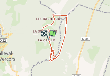
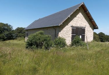
Randonnée A pied de 6,9 km à découvrir à Auvergne-Rhône-Alpes, Isère, Malleval-en-Vercors. Cette randonnée est proposée par crocau.
Description
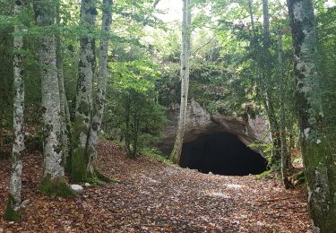
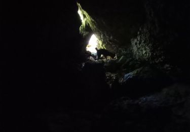
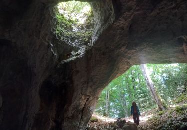
De la Ferme de La Caille, rejoindre le Col de Neurre puis traverser les prés puis les bois sous le Bec (très difficile). Sous le Bec on trouve une sente que l'on crapahute . La vue du Bec est imprenable.
On traverse les bois soit avec l'application , soit on longe les crêtes où l'on trouve un sentier. On rejoint alors le sentier officiel et le Pas du Follet ( joli point de vue) et on redescend à la Ferme.
Localisation
Commentaires
Randonnées à proximité
![Randonnée Marche Cognin-les-Gorges - gerlette abs - Photo](https://media.geolcdn.com/t/375/260/c8110e9f-bd5d-4d92-bba6-1a7936beeb04.jpg&format=jpg&maxdim=2)
![Marche Marche](https://static1.geolcdn.com/sitytour/trail-icons/101.png)
Marche
![](/images/other/stat-length.png)
![](https://static1.geolcdn.com/siteimages/upload/files/16400158638029165_repeat_loop_refresh_sync_direction_icon.png)
![Randonnée Marche Malleval-en-Vercors - pas du Follet en boucle - Photo](https://media.geolcdn.com/t/375/260/ext.jpg?maxdim=2&url=https%3A%2F%2Fstatic1.geolcdn.com%2Fsiteimages%2Fupload%2Ffiles%2F1553511878bg_sport_marche.png)
![Marche Marche](https://static1.geolcdn.com/sitytour/trail-icons/101.png)
Marche
![](/images/other/stat-length.png)
![](https://static1.geolcdn.com/siteimages/upload/files/16400158638029165_repeat_loop_refresh_sync_direction_icon.png)
![Randonnée Marche Malleval-en-Vercors - Patente - Photo](https://media.geolcdn.com/t/375/260/60b129ee-9863-458f-8d0b-886077adfedf.jpg&format=jpg&maxdim=2)
![Marche Marche](https://static1.geolcdn.com/sitytour/trail-icons/101.png)
Marche
![](/images/other/stat-length.png)
![](https://static1.geolcdn.com/siteimages/upload/files/16400158638029165_repeat_loop_refresh_sync_direction_icon.png)
![Randonnée Marche Saint-Gervais - Les Écouges - Pas de Pierre Taillée - Photo](https://media.geolcdn.com/t/375/260/c1514613-b24f-48ec-aa78-bb7bfa66a6b4.jpg&format=jpg&maxdim=2)
![Marche Marche](https://static1.geolcdn.com/sitytour/trail-icons/101.png)
Marche
![](/images/other/stat-length.png)
![](https://static1.geolcdn.com/siteimages/upload/files/16400158638029165_repeat_loop_refresh_sync_direction_icon.png)
![Randonnée Marche Cognin-les-Gorges - Cognin-les-Gorges - Gorges du Nan - Malleval-en-Vercors - Photo](https://media.geolcdn.com/t/375/260/ade7945e-a7c5-44bc-b392-a4cb822d8799.jpg&format=jpg&maxdim=2)
![Marche Marche](https://static1.geolcdn.com/sitytour/trail-icons/101.png)
Marche
![](/images/other/stat-length.png)
![](https://static1.geolcdn.com/siteimages/upload/files/16400158638029165_repeat_loop_refresh_sync_direction_icon.png)
![Randonnée Marche Saint-Pierre-de-Chérennes - Les Coulmes - La Lunette - Photo](https://media.geolcdn.com/t/375/260/3a4910c5-13ba-451d-9478-dccf34306295.jpg&format=jpg&maxdim=2)
![Marche Marche](https://static1.geolcdn.com/sitytour/trail-icons/101.png)
Marche
![](/images/other/stat-length.png)
![](https://static1.geolcdn.com/siteimages/upload/files/16400158638029165_repeat_loop_refresh_sync_direction_icon.png)
![Randonnée Marche Presles - Coulmes - La Fontaine de Pétouze par la grotte des Boeufs - Photo](https://media.geolcdn.com/t/375/260/fe4f0ce9-4c0f-4a57-8bf8-01fb087e941a.jpg&format=jpg&maxdim=2)
![Marche Marche](https://static1.geolcdn.com/sitytour/trail-icons/101.png)
Marche
![](/images/other/stat-length.png)
![](https://static1.geolcdn.com/siteimages/upload/files/16400158638029165_repeat_loop_refresh_sync_direction_icon.png)
![Randonnée Marche Izeron - La lunette- fontaine et grotte de Byry - Photo](https://media.geolcdn.com/t/375/260/19a19cfc-ea7d-4041-87a8-5cc1f600b8bb.jpg&format=jpg&maxdim=2)
![Marche Marche](https://static1.geolcdn.com/sitytour/trail-icons/101.png)
Marche
![](/images/other/stat-length.png)
![](https://static1.geolcdn.com/siteimages/upload/files/16400158638029165_repeat_loop_refresh_sync_direction_icon.png)
![Randonnée Marche Presles - Fontaine de Pétouze- Grotte des boeufs - Photo](https://media.geolcdn.com/t/375/260/6b7d14d3-f76a-45c6-9cc9-34bf1f24a155.jpg&format=jpg&maxdim=2)
![Marche Marche](https://static1.geolcdn.com/sitytour/trail-icons/101.png)
Marche
![](/images/other/stat-length.png)
![](https://static1.geolcdn.com/siteimages/upload/files/16400158638029165_repeat_loop_refresh_sync_direction_icon.png)