


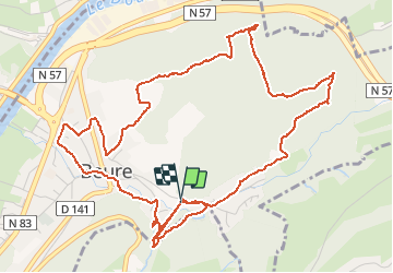

16,8 km | 24 km-effort

Utilisateur


Application GPS de randonnée GRATUITE
 SityTrail
IGN / Instituts géographiques
SityTrail World
Le monde est à vous
Randonnée Marche de 7 km à découvrir à Bourgogne-Franche-Comté, Doubs, Beure. Cette randonnée est proposée par eltonnermou.
Ce parcours pédestre, en empruntant (proche du départ) la voie celtique/romaine, vous entrainera le long de la cascade de la pisseur puis sur la colline du "bois de peu". Après (et lors de) la montée profitez des divers points de vue sur le Doubs, les quartiers de Besançon, le village de Beure. Lorsque vous emprunterez la sommière (suivant le sens de votre trajet), soit la montée, soit la descente est raide (200m) prudence.
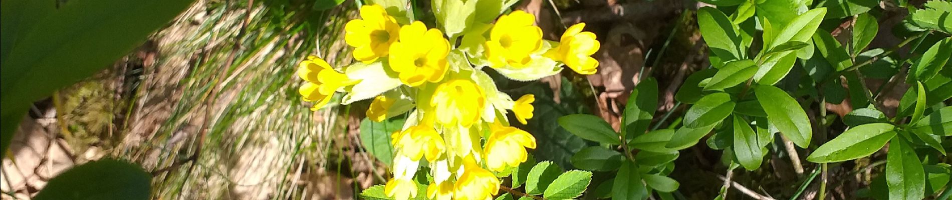
Avec un peu de chance, vous surprendrez des chamois sur les pentes escarpées du secteur et peut-être des sangliers. Vous pourrez apprécier la diversité de la flore.
 "
data-pinterest-text="Pin it"
data-tweet-text="share on twitter"
data-facebook-share-url="https://www.sitytrail.com/fr/trails/2375815-beure--xgrand-tourx-pisseur-x-che-bailly-x-cote-blanche--x-sommiere-/?photo=1#lg=1&slide=1"
data-twitter-share-url="https://www.sitytrail.com/fr/trails/2375815-beure--xgrand-tourx-pisseur-x-che-bailly-x-cote-blanche--x-sommiere-/?photo=1#lg=1&slide=1"
data-googleplus-share-url="https://www.sitytrail.com/fr/trails/2375815-beure--xgrand-tourx-pisseur-x-che-bailly-x-cote-blanche--x-sommiere-/?photo=1#lg=1&slide=1"
data-pinterest-share-url="https://www.sitytrail.com/fr/trails/2375815-beure--xgrand-tourx-pisseur-x-che-bailly-x-cote-blanche--x-sommiere-/?photo=1#lg=1&slide=1">
"
data-pinterest-text="Pin it"
data-tweet-text="share on twitter"
data-facebook-share-url="https://www.sitytrail.com/fr/trails/2375815-beure--xgrand-tourx-pisseur-x-che-bailly-x-cote-blanche--x-sommiere-/?photo=1#lg=1&slide=1"
data-twitter-share-url="https://www.sitytrail.com/fr/trails/2375815-beure--xgrand-tourx-pisseur-x-che-bailly-x-cote-blanche--x-sommiere-/?photo=1#lg=1&slide=1"
data-googleplus-share-url="https://www.sitytrail.com/fr/trails/2375815-beure--xgrand-tourx-pisseur-x-che-bailly-x-cote-blanche--x-sommiere-/?photo=1#lg=1&slide=1"
data-pinterest-share-url="https://www.sitytrail.com/fr/trails/2375815-beure--xgrand-tourx-pisseur-x-che-bailly-x-cote-blanche--x-sommiere-/?photo=1#lg=1&slide=1">
 "
data-pinterest-text="Pin it"
data-tweet-text="share on twitter"
data-facebook-share-url="https://www.sitytrail.com/fr/trails/2375815-beure--xgrand-tourx-pisseur-x-che-bailly-x-cote-blanche--x-sommiere-/?photo=2#lg=1&slide=2"
data-twitter-share-url="https://www.sitytrail.com/fr/trails/2375815-beure--xgrand-tourx-pisseur-x-che-bailly-x-cote-blanche--x-sommiere-/?photo=2#lg=1&slide=2"
data-googleplus-share-url="https://www.sitytrail.com/fr/trails/2375815-beure--xgrand-tourx-pisseur-x-che-bailly-x-cote-blanche--x-sommiere-/?photo=2#lg=1&slide=2"
data-pinterest-share-url="https://www.sitytrail.com/fr/trails/2375815-beure--xgrand-tourx-pisseur-x-che-bailly-x-cote-blanche--x-sommiere-/?photo=2#lg=1&slide=2">
"
data-pinterest-text="Pin it"
data-tweet-text="share on twitter"
data-facebook-share-url="https://www.sitytrail.com/fr/trails/2375815-beure--xgrand-tourx-pisseur-x-che-bailly-x-cote-blanche--x-sommiere-/?photo=2#lg=1&slide=2"
data-twitter-share-url="https://www.sitytrail.com/fr/trails/2375815-beure--xgrand-tourx-pisseur-x-che-bailly-x-cote-blanche--x-sommiere-/?photo=2#lg=1&slide=2"
data-googleplus-share-url="https://www.sitytrail.com/fr/trails/2375815-beure--xgrand-tourx-pisseur-x-che-bailly-x-cote-blanche--x-sommiere-/?photo=2#lg=1&slide=2"
data-pinterest-share-url="https://www.sitytrail.com/fr/trails/2375815-beure--xgrand-tourx-pisseur-x-che-bailly-x-cote-blanche--x-sommiere-/?photo=2#lg=1&slide=2">
 "
data-pinterest-text="Pin it"
data-tweet-text="share on twitter"
data-facebook-share-url="https://www.sitytrail.com/fr/trails/2375815-beure--xgrand-tourx-pisseur-x-che-bailly-x-cote-blanche--x-sommiere-/?photo=3#lg=1&slide=3"
data-twitter-share-url="https://www.sitytrail.com/fr/trails/2375815-beure--xgrand-tourx-pisseur-x-che-bailly-x-cote-blanche--x-sommiere-/?photo=3#lg=1&slide=3"
data-googleplus-share-url="https://www.sitytrail.com/fr/trails/2375815-beure--xgrand-tourx-pisseur-x-che-bailly-x-cote-blanche--x-sommiere-/?photo=3#lg=1&slide=3"
data-pinterest-share-url="https://www.sitytrail.com/fr/trails/2375815-beure--xgrand-tourx-pisseur-x-che-bailly-x-cote-blanche--x-sommiere-/?photo=3#lg=1&slide=3">
"
data-pinterest-text="Pin it"
data-tweet-text="share on twitter"
data-facebook-share-url="https://www.sitytrail.com/fr/trails/2375815-beure--xgrand-tourx-pisseur-x-che-bailly-x-cote-blanche--x-sommiere-/?photo=3#lg=1&slide=3"
data-twitter-share-url="https://www.sitytrail.com/fr/trails/2375815-beure--xgrand-tourx-pisseur-x-che-bailly-x-cote-blanche--x-sommiere-/?photo=3#lg=1&slide=3"
data-googleplus-share-url="https://www.sitytrail.com/fr/trails/2375815-beure--xgrand-tourx-pisseur-x-che-bailly-x-cote-blanche--x-sommiere-/?photo=3#lg=1&slide=3"
data-pinterest-share-url="https://www.sitytrail.com/fr/trails/2375815-beure--xgrand-tourx-pisseur-x-che-bailly-x-cote-blanche--x-sommiere-/?photo=3#lg=1&slide=3">
 "
data-pinterest-text="Pin it"
data-tweet-text="share on twitter"
data-facebook-share-url="https://www.sitytrail.com/fr/trails/2375815-beure--xgrand-tourx-pisseur-x-che-bailly-x-cote-blanche--x-sommiere-/?photo=4#lg=1&slide=4"
data-twitter-share-url="https://www.sitytrail.com/fr/trails/2375815-beure--xgrand-tourx-pisseur-x-che-bailly-x-cote-blanche--x-sommiere-/?photo=4#lg=1&slide=4"
data-googleplus-share-url="https://www.sitytrail.com/fr/trails/2375815-beure--xgrand-tourx-pisseur-x-che-bailly-x-cote-blanche--x-sommiere-/?photo=4#lg=1&slide=4"
data-pinterest-share-url="https://www.sitytrail.com/fr/trails/2375815-beure--xgrand-tourx-pisseur-x-che-bailly-x-cote-blanche--x-sommiere-/?photo=4#lg=1&slide=4">
"
data-pinterest-text="Pin it"
data-tweet-text="share on twitter"
data-facebook-share-url="https://www.sitytrail.com/fr/trails/2375815-beure--xgrand-tourx-pisseur-x-che-bailly-x-cote-blanche--x-sommiere-/?photo=4#lg=1&slide=4"
data-twitter-share-url="https://www.sitytrail.com/fr/trails/2375815-beure--xgrand-tourx-pisseur-x-che-bailly-x-cote-blanche--x-sommiere-/?photo=4#lg=1&slide=4"
data-googleplus-share-url="https://www.sitytrail.com/fr/trails/2375815-beure--xgrand-tourx-pisseur-x-che-bailly-x-cote-blanche--x-sommiere-/?photo=4#lg=1&slide=4"
data-pinterest-share-url="https://www.sitytrail.com/fr/trails/2375815-beure--xgrand-tourx-pisseur-x-che-bailly-x-cote-blanche--x-sommiere-/?photo=4#lg=1&slide=4">
 "
data-pinterest-text="Pin it"
data-tweet-text="share on twitter"
data-facebook-share-url="https://www.sitytrail.com/fr/trails/2375815-beure--xgrand-tourx-pisseur-x-che-bailly-x-cote-blanche--x-sommiere-/?photo=5#lg=1&slide=5"
data-twitter-share-url="https://www.sitytrail.com/fr/trails/2375815-beure--xgrand-tourx-pisseur-x-che-bailly-x-cote-blanche--x-sommiere-/?photo=5#lg=1&slide=5"
data-googleplus-share-url="https://www.sitytrail.com/fr/trails/2375815-beure--xgrand-tourx-pisseur-x-che-bailly-x-cote-blanche--x-sommiere-/?photo=5#lg=1&slide=5"
data-pinterest-share-url="https://www.sitytrail.com/fr/trails/2375815-beure--xgrand-tourx-pisseur-x-che-bailly-x-cote-blanche--x-sommiere-/?photo=5#lg=1&slide=5">
"
data-pinterest-text="Pin it"
data-tweet-text="share on twitter"
data-facebook-share-url="https://www.sitytrail.com/fr/trails/2375815-beure--xgrand-tourx-pisseur-x-che-bailly-x-cote-blanche--x-sommiere-/?photo=5#lg=1&slide=5"
data-twitter-share-url="https://www.sitytrail.com/fr/trails/2375815-beure--xgrand-tourx-pisseur-x-che-bailly-x-cote-blanche--x-sommiere-/?photo=5#lg=1&slide=5"
data-googleplus-share-url="https://www.sitytrail.com/fr/trails/2375815-beure--xgrand-tourx-pisseur-x-che-bailly-x-cote-blanche--x-sommiere-/?photo=5#lg=1&slide=5"
data-pinterest-share-url="https://www.sitytrail.com/fr/trails/2375815-beure--xgrand-tourx-pisseur-x-che-bailly-x-cote-blanche--x-sommiere-/?photo=5#lg=1&slide=5">
 "
data-pinterest-text="Pin it"
data-tweet-text="share on twitter"
data-facebook-share-url="https://www.sitytrail.com/fr/trails/2375815-beure--xgrand-tourx-pisseur-x-che-bailly-x-cote-blanche--x-sommiere-/?photo=6#lg=1&slide=6"
data-twitter-share-url="https://www.sitytrail.com/fr/trails/2375815-beure--xgrand-tourx-pisseur-x-che-bailly-x-cote-blanche--x-sommiere-/?photo=6#lg=1&slide=6"
data-googleplus-share-url="https://www.sitytrail.com/fr/trails/2375815-beure--xgrand-tourx-pisseur-x-che-bailly-x-cote-blanche--x-sommiere-/?photo=6#lg=1&slide=6"
data-pinterest-share-url="https://www.sitytrail.com/fr/trails/2375815-beure--xgrand-tourx-pisseur-x-che-bailly-x-cote-blanche--x-sommiere-/?photo=6#lg=1&slide=6">
"
data-pinterest-text="Pin it"
data-tweet-text="share on twitter"
data-facebook-share-url="https://www.sitytrail.com/fr/trails/2375815-beure--xgrand-tourx-pisseur-x-che-bailly-x-cote-blanche--x-sommiere-/?photo=6#lg=1&slide=6"
data-twitter-share-url="https://www.sitytrail.com/fr/trails/2375815-beure--xgrand-tourx-pisseur-x-che-bailly-x-cote-blanche--x-sommiere-/?photo=6#lg=1&slide=6"
data-googleplus-share-url="https://www.sitytrail.com/fr/trails/2375815-beure--xgrand-tourx-pisseur-x-che-bailly-x-cote-blanche--x-sommiere-/?photo=6#lg=1&slide=6"
data-pinterest-share-url="https://www.sitytrail.com/fr/trails/2375815-beure--xgrand-tourx-pisseur-x-che-bailly-x-cote-blanche--x-sommiere-/?photo=6#lg=1&slide=6">
 "
data-pinterest-text="Pin it"
data-tweet-text="share on twitter"
data-facebook-share-url="https://www.sitytrail.com/fr/trails/2375815-beure--xgrand-tourx-pisseur-x-che-bailly-x-cote-blanche--x-sommiere-/?photo=7#lg=1&slide=7"
data-twitter-share-url="https://www.sitytrail.com/fr/trails/2375815-beure--xgrand-tourx-pisseur-x-che-bailly-x-cote-blanche--x-sommiere-/?photo=7#lg=1&slide=7"
data-googleplus-share-url="https://www.sitytrail.com/fr/trails/2375815-beure--xgrand-tourx-pisseur-x-che-bailly-x-cote-blanche--x-sommiere-/?photo=7#lg=1&slide=7"
data-pinterest-share-url="https://www.sitytrail.com/fr/trails/2375815-beure--xgrand-tourx-pisseur-x-che-bailly-x-cote-blanche--x-sommiere-/?photo=7#lg=1&slide=7">
"
data-pinterest-text="Pin it"
data-tweet-text="share on twitter"
data-facebook-share-url="https://www.sitytrail.com/fr/trails/2375815-beure--xgrand-tourx-pisseur-x-che-bailly-x-cote-blanche--x-sommiere-/?photo=7#lg=1&slide=7"
data-twitter-share-url="https://www.sitytrail.com/fr/trails/2375815-beure--xgrand-tourx-pisseur-x-che-bailly-x-cote-blanche--x-sommiere-/?photo=7#lg=1&slide=7"
data-googleplus-share-url="https://www.sitytrail.com/fr/trails/2375815-beure--xgrand-tourx-pisseur-x-che-bailly-x-cote-blanche--x-sommiere-/?photo=7#lg=1&slide=7"
data-pinterest-share-url="https://www.sitytrail.com/fr/trails/2375815-beure--xgrand-tourx-pisseur-x-che-bailly-x-cote-blanche--x-sommiere-/?photo=7#lg=1&slide=7">
 "
data-pinterest-text="Pin it"
data-tweet-text="share on twitter"
data-facebook-share-url="https://www.sitytrail.com/fr/trails/2375815-beure--xgrand-tourx-pisseur-x-che-bailly-x-cote-blanche--x-sommiere-/?photo=8#lg=1&slide=8"
data-twitter-share-url="https://www.sitytrail.com/fr/trails/2375815-beure--xgrand-tourx-pisseur-x-che-bailly-x-cote-blanche--x-sommiere-/?photo=8#lg=1&slide=8"
data-googleplus-share-url="https://www.sitytrail.com/fr/trails/2375815-beure--xgrand-tourx-pisseur-x-che-bailly-x-cote-blanche--x-sommiere-/?photo=8#lg=1&slide=8"
data-pinterest-share-url="https://www.sitytrail.com/fr/trails/2375815-beure--xgrand-tourx-pisseur-x-che-bailly-x-cote-blanche--x-sommiere-/?photo=8#lg=1&slide=8">
"
data-pinterest-text="Pin it"
data-tweet-text="share on twitter"
data-facebook-share-url="https://www.sitytrail.com/fr/trails/2375815-beure--xgrand-tourx-pisseur-x-che-bailly-x-cote-blanche--x-sommiere-/?photo=8#lg=1&slide=8"
data-twitter-share-url="https://www.sitytrail.com/fr/trails/2375815-beure--xgrand-tourx-pisseur-x-che-bailly-x-cote-blanche--x-sommiere-/?photo=8#lg=1&slide=8"
data-googleplus-share-url="https://www.sitytrail.com/fr/trails/2375815-beure--xgrand-tourx-pisseur-x-che-bailly-x-cote-blanche--x-sommiere-/?photo=8#lg=1&slide=8"
data-pinterest-share-url="https://www.sitytrail.com/fr/trails/2375815-beure--xgrand-tourx-pisseur-x-che-bailly-x-cote-blanche--x-sommiere-/?photo=8#lg=1&slide=8">
 "
data-pinterest-text="Pin it"
data-tweet-text="share on twitter"
data-facebook-share-url="https://www.sitytrail.com/fr/trails/2375815-beure--xgrand-tourx-pisseur-x-che-bailly-x-cote-blanche--x-sommiere-/?photo=9#lg=1&slide=9"
data-twitter-share-url="https://www.sitytrail.com/fr/trails/2375815-beure--xgrand-tourx-pisseur-x-che-bailly-x-cote-blanche--x-sommiere-/?photo=9#lg=1&slide=9"
data-googleplus-share-url="https://www.sitytrail.com/fr/trails/2375815-beure--xgrand-tourx-pisseur-x-che-bailly-x-cote-blanche--x-sommiere-/?photo=9#lg=1&slide=9"
data-pinterest-share-url="https://www.sitytrail.com/fr/trails/2375815-beure--xgrand-tourx-pisseur-x-che-bailly-x-cote-blanche--x-sommiere-/?photo=9#lg=1&slide=9">
"
data-pinterest-text="Pin it"
data-tweet-text="share on twitter"
data-facebook-share-url="https://www.sitytrail.com/fr/trails/2375815-beure--xgrand-tourx-pisseur-x-che-bailly-x-cote-blanche--x-sommiere-/?photo=9#lg=1&slide=9"
data-twitter-share-url="https://www.sitytrail.com/fr/trails/2375815-beure--xgrand-tourx-pisseur-x-che-bailly-x-cote-blanche--x-sommiere-/?photo=9#lg=1&slide=9"
data-googleplus-share-url="https://www.sitytrail.com/fr/trails/2375815-beure--xgrand-tourx-pisseur-x-che-bailly-x-cote-blanche--x-sommiere-/?photo=9#lg=1&slide=9"
data-pinterest-share-url="https://www.sitytrail.com/fr/trails/2375815-beure--xgrand-tourx-pisseur-x-che-bailly-x-cote-blanche--x-sommiere-/?photo=9#lg=1&slide=9">
 "
data-pinterest-text="Pin it"
data-tweet-text="share on twitter"
data-facebook-share-url="https://www.sitytrail.com/fr/trails/2375815-beure--xgrand-tourx-pisseur-x-che-bailly-x-cote-blanche--x-sommiere-/?photo=10#lg=1&slide=10"
data-twitter-share-url="https://www.sitytrail.com/fr/trails/2375815-beure--xgrand-tourx-pisseur-x-che-bailly-x-cote-blanche--x-sommiere-/?photo=10#lg=1&slide=10"
data-googleplus-share-url="https://www.sitytrail.com/fr/trails/2375815-beure--xgrand-tourx-pisseur-x-che-bailly-x-cote-blanche--x-sommiere-/?photo=10#lg=1&slide=10"
data-pinterest-share-url="https://www.sitytrail.com/fr/trails/2375815-beure--xgrand-tourx-pisseur-x-che-bailly-x-cote-blanche--x-sommiere-/?photo=10#lg=1&slide=10">
"
data-pinterest-text="Pin it"
data-tweet-text="share on twitter"
data-facebook-share-url="https://www.sitytrail.com/fr/trails/2375815-beure--xgrand-tourx-pisseur-x-che-bailly-x-cote-blanche--x-sommiere-/?photo=10#lg=1&slide=10"
data-twitter-share-url="https://www.sitytrail.com/fr/trails/2375815-beure--xgrand-tourx-pisseur-x-che-bailly-x-cote-blanche--x-sommiere-/?photo=10#lg=1&slide=10"
data-googleplus-share-url="https://www.sitytrail.com/fr/trails/2375815-beure--xgrand-tourx-pisseur-x-che-bailly-x-cote-blanche--x-sommiere-/?photo=10#lg=1&slide=10"
data-pinterest-share-url="https://www.sitytrail.com/fr/trails/2375815-beure--xgrand-tourx-pisseur-x-che-bailly-x-cote-blanche--x-sommiere-/?photo=10#lg=1&slide=10">
 "
data-pinterest-text="Pin it"
data-tweet-text="share on twitter"
data-facebook-share-url="https://www.sitytrail.com/fr/trails/2375815-beure--xgrand-tourx-pisseur-x-che-bailly-x-cote-blanche--x-sommiere-/?photo=11#lg=1&slide=11"
data-twitter-share-url="https://www.sitytrail.com/fr/trails/2375815-beure--xgrand-tourx-pisseur-x-che-bailly-x-cote-blanche--x-sommiere-/?photo=11#lg=1&slide=11"
data-googleplus-share-url="https://www.sitytrail.com/fr/trails/2375815-beure--xgrand-tourx-pisseur-x-che-bailly-x-cote-blanche--x-sommiere-/?photo=11#lg=1&slide=11"
data-pinterest-share-url="https://www.sitytrail.com/fr/trails/2375815-beure--xgrand-tourx-pisseur-x-che-bailly-x-cote-blanche--x-sommiere-/?photo=11#lg=1&slide=11">
"
data-pinterest-text="Pin it"
data-tweet-text="share on twitter"
data-facebook-share-url="https://www.sitytrail.com/fr/trails/2375815-beure--xgrand-tourx-pisseur-x-che-bailly-x-cote-blanche--x-sommiere-/?photo=11#lg=1&slide=11"
data-twitter-share-url="https://www.sitytrail.com/fr/trails/2375815-beure--xgrand-tourx-pisseur-x-che-bailly-x-cote-blanche--x-sommiere-/?photo=11#lg=1&slide=11"
data-googleplus-share-url="https://www.sitytrail.com/fr/trails/2375815-beure--xgrand-tourx-pisseur-x-che-bailly-x-cote-blanche--x-sommiere-/?photo=11#lg=1&slide=11"
data-pinterest-share-url="https://www.sitytrail.com/fr/trails/2375815-beure--xgrand-tourx-pisseur-x-che-bailly-x-cote-blanche--x-sommiere-/?photo=11#lg=1&slide=11">
 "
data-pinterest-text="Pin it"
data-tweet-text="share on twitter"
data-facebook-share-url="https://www.sitytrail.com/fr/trails/2375815-beure--xgrand-tourx-pisseur-x-che-bailly-x-cote-blanche--x-sommiere-/?photo=12#lg=1&slide=12"
data-twitter-share-url="https://www.sitytrail.com/fr/trails/2375815-beure--xgrand-tourx-pisseur-x-che-bailly-x-cote-blanche--x-sommiere-/?photo=12#lg=1&slide=12"
data-googleplus-share-url="https://www.sitytrail.com/fr/trails/2375815-beure--xgrand-tourx-pisseur-x-che-bailly-x-cote-blanche--x-sommiere-/?photo=12#lg=1&slide=12"
data-pinterest-share-url="https://www.sitytrail.com/fr/trails/2375815-beure--xgrand-tourx-pisseur-x-che-bailly-x-cote-blanche--x-sommiere-/?photo=12#lg=1&slide=12">
"
data-pinterest-text="Pin it"
data-tweet-text="share on twitter"
data-facebook-share-url="https://www.sitytrail.com/fr/trails/2375815-beure--xgrand-tourx-pisseur-x-che-bailly-x-cote-blanche--x-sommiere-/?photo=12#lg=1&slide=12"
data-twitter-share-url="https://www.sitytrail.com/fr/trails/2375815-beure--xgrand-tourx-pisseur-x-che-bailly-x-cote-blanche--x-sommiere-/?photo=12#lg=1&slide=12"
data-googleplus-share-url="https://www.sitytrail.com/fr/trails/2375815-beure--xgrand-tourx-pisseur-x-che-bailly-x-cote-blanche--x-sommiere-/?photo=12#lg=1&slide=12"
data-pinterest-share-url="https://www.sitytrail.com/fr/trails/2375815-beure--xgrand-tourx-pisseur-x-che-bailly-x-cote-blanche--x-sommiere-/?photo=12#lg=1&slide=12">
 "
data-pinterest-text="Pin it"
data-tweet-text="share on twitter"
data-facebook-share-url="https://www.sitytrail.com/fr/trails/2375815-beure--xgrand-tourx-pisseur-x-che-bailly-x-cote-blanche--x-sommiere-/?photo=13#lg=1&slide=13"
data-twitter-share-url="https://www.sitytrail.com/fr/trails/2375815-beure--xgrand-tourx-pisseur-x-che-bailly-x-cote-blanche--x-sommiere-/?photo=13#lg=1&slide=13"
data-googleplus-share-url="https://www.sitytrail.com/fr/trails/2375815-beure--xgrand-tourx-pisseur-x-che-bailly-x-cote-blanche--x-sommiere-/?photo=13#lg=1&slide=13"
data-pinterest-share-url="https://www.sitytrail.com/fr/trails/2375815-beure--xgrand-tourx-pisseur-x-che-bailly-x-cote-blanche--x-sommiere-/?photo=13#lg=1&slide=13">
"
data-pinterest-text="Pin it"
data-tweet-text="share on twitter"
data-facebook-share-url="https://www.sitytrail.com/fr/trails/2375815-beure--xgrand-tourx-pisseur-x-che-bailly-x-cote-blanche--x-sommiere-/?photo=13#lg=1&slide=13"
data-twitter-share-url="https://www.sitytrail.com/fr/trails/2375815-beure--xgrand-tourx-pisseur-x-che-bailly-x-cote-blanche--x-sommiere-/?photo=13#lg=1&slide=13"
data-googleplus-share-url="https://www.sitytrail.com/fr/trails/2375815-beure--xgrand-tourx-pisseur-x-che-bailly-x-cote-blanche--x-sommiere-/?photo=13#lg=1&slide=13"
data-pinterest-share-url="https://www.sitytrail.com/fr/trails/2375815-beure--xgrand-tourx-pisseur-x-che-bailly-x-cote-blanche--x-sommiere-/?photo=13#lg=1&slide=13">
 "
data-pinterest-text="Pin it"
data-tweet-text="share on twitter"
data-facebook-share-url="https://www.sitytrail.com/fr/trails/2375815-beure--xgrand-tourx-pisseur-x-che-bailly-x-cote-blanche--x-sommiere-/?photo=14#lg=1&slide=14"
data-twitter-share-url="https://www.sitytrail.com/fr/trails/2375815-beure--xgrand-tourx-pisseur-x-che-bailly-x-cote-blanche--x-sommiere-/?photo=14#lg=1&slide=14"
data-googleplus-share-url="https://www.sitytrail.com/fr/trails/2375815-beure--xgrand-tourx-pisseur-x-che-bailly-x-cote-blanche--x-sommiere-/?photo=14#lg=1&slide=14"
data-pinterest-share-url="https://www.sitytrail.com/fr/trails/2375815-beure--xgrand-tourx-pisseur-x-che-bailly-x-cote-blanche--x-sommiere-/?photo=14#lg=1&slide=14">
"
data-pinterest-text="Pin it"
data-tweet-text="share on twitter"
data-facebook-share-url="https://www.sitytrail.com/fr/trails/2375815-beure--xgrand-tourx-pisseur-x-che-bailly-x-cote-blanche--x-sommiere-/?photo=14#lg=1&slide=14"
data-twitter-share-url="https://www.sitytrail.com/fr/trails/2375815-beure--xgrand-tourx-pisseur-x-che-bailly-x-cote-blanche--x-sommiere-/?photo=14#lg=1&slide=14"
data-googleplus-share-url="https://www.sitytrail.com/fr/trails/2375815-beure--xgrand-tourx-pisseur-x-che-bailly-x-cote-blanche--x-sommiere-/?photo=14#lg=1&slide=14"
data-pinterest-share-url="https://www.sitytrail.com/fr/trails/2375815-beure--xgrand-tourx-pisseur-x-che-bailly-x-cote-blanche--x-sommiere-/?photo=14#lg=1&slide=14">


Marche

Marche

Marche

Marche

Marche

A pied

A pied

A pied

A pied