![](/images/other/stat-length.png)
![Randonnée A pied Pégomas - FARANDOLE:PEGOMAS,CABRIS - Photo](https://media.geolcdn.com/t/1900/400/ext.pjpeg?maxdim=2&url=https%3A%2F%2Fstatic1.geolcdn.com%2Fsiteimages%2Fupload%2Ffiles%2F1545311037marcheuse_200dpi.jpg)
FARANDOLE:PEGOMAS,CABRIS
mjfscacrando
Utilisateur
![Longueur](/images/other/stat-length.png)
Longueur
14,1 km
![Altitude max](https://static1.geolcdn.com/siteimages/upload/files/1508320355ic_sort_altitude_max_24dp.png)
Altitude max
556 m
![Dénivelé positif](https://static1.geolcdn.com/siteimages/upload/files/1508320355ic_sort_den_pos_24dp.png)
Dénivelé positif
791 m
![Km-Effort](/images/other/stat-length.png)
Km-Effort
23 km
![Altitude min](https://static1.geolcdn.com/siteimages/upload/files/1508320355ic_sort_altitude_min_24dp.png)
Altitude min
16 m
![Dénivelé négatif](https://static1.geolcdn.com/siteimages/upload/files/1508320355ic_sort_den_neg_24dp.png)
Dénivelé négatif
255 m
![Boucle](https://static1.geolcdn.com/siteimages/upload/files/16400158638029165_repeat_loop_refresh_sync_direction_icon.png)
Boucle
Non
Date de création :
2020-03-29 13:45:00.673
Dernière modification :
2020-03-29 13:48:59.342
![A pied](https://static1.geolcdn.com/sitytour/trail-icons/100.png)
--
Difficulté : Moyen
![Scannez ce code QR pour ouvrir la randonnée dans l'application SityTrail](https://capi.geolives.com/qq0zvz2zws4bq2lad0pu/sitytour/trails/2371598/qr.png?size=200)
Application GPS de randonnée GRATUITE
À propos
Randonnée A pied de 14,1 km à découvrir à Provence-Alpes-Côte d'Azur, Alpes-Maritimes, Pégomas. Cette randonnée est proposée par mjfscacrando.
Description
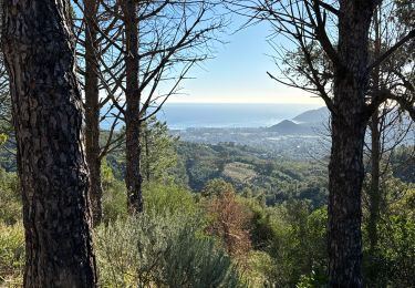
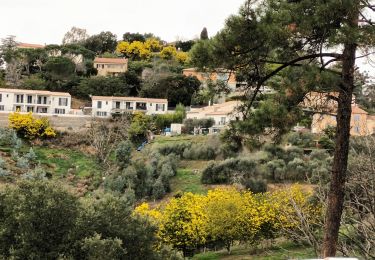
Au départ de Pégomas on longe la Siagne, viste d'Auribeau,point de vue sur l'arriere pays grassois au Peyre- gros,arrivé à Cabris .
Localisation
Pays :
France
Région :
Provence-Alpes-Côte d'Azur
Département/Province :
Alpes-Maritimes
Commune :
Pégomas
Localité :
Unknown
Départ:(Dec)
Départ:(UTM)
332645 ; 4828877 (32T) N.
Commentaires
Randonnées à proximité
![Randonnée Marche Tanneron - Tanneron les mimosas - Photo](https://media.geolcdn.com/t/375/260/12594504-e357-426b-8d56-deee61931ae8.jpg&format=jpg&maxdim=2)
![Marche Marche](https://static1.geolcdn.com/sitytour/trail-icons/101.png)
Tanneron les mimosas
Marche
Très facile
(1)
Tanneron,
Provence-Alpes-Côte d'Azur,
Var,
France
![](/images/other/stat-length.png)
12 km | 17,8 km-effort
3h 25min
![](https://static1.geolcdn.com/siteimages/upload/files/16400158638029165_repeat_loop_refresh_sync_direction_icon.png)
Oui
![Randonnée Marche Tanneron - Tanneron - petite boucle 12-02-2022 - Photo](https://media.geolcdn.com/t/375/260/4604518f-6a34-43cf-8b51-a998f24d7a22.jpg&format=jpg&maxdim=2)
![Marche Marche](https://static1.geolcdn.com/sitytour/trail-icons/101.png)
Tanneron - petite boucle 12-02-2022
Marche
Facile
Tanneron,
Provence-Alpes-Côte d'Azur,
Var,
France
![](/images/other/stat-length.png)
7,5 km | 10,8 km-effort
2h 0min
![](https://static1.geolcdn.com/siteimages/upload/files/16400158638029165_repeat_loop_refresh_sync_direction_icon.png)
Oui
![Randonnée Marche Mandelieu-la-Napoule - Grand Duc Alternatif - Photo](https://media.geolcdn.com/t/375/260/ext.jpg?maxdim=2&url=https%3A%2F%2Fstatic1.geolcdn.com%2Fsiteimages%2Fupload%2Ffiles%2F1553511878bg_sport_marche.png)
![Marche Marche](https://static1.geolcdn.com/sitytour/trail-icons/101.png)
Grand Duc Alternatif
Marche
Très facile
(1)
Mandelieu-la-Napoule,
Provence-Alpes-Côte d'Azur,
Alpes-Maritimes,
France
![](/images/other/stat-length.png)
6,4 km | 9,1 km-effort
2h 0min
![](https://static1.geolcdn.com/siteimages/upload/files/16400158638029165_repeat_loop_refresh_sync_direction_icon.png)
Oui
![Randonnée Marche Mandelieu-la-Napoule - Grand Duc - Photo](https://media.geolcdn.com/t/375/260/bb4952b6-32f3-40dd-b274-07cfc3d80de4.jpg&format=jpg&maxdim=2)
![Marche Marche](https://static1.geolcdn.com/sitytour/trail-icons/101.png)
Grand Duc
Marche
Moyen
Mandelieu-la-Napoule,
Provence-Alpes-Côte d'Azur,
Alpes-Maritimes,
France
![](/images/other/stat-length.png)
8,9 km | 12,5 km-effort
2h 47min
![](https://static1.geolcdn.com/siteimages/upload/files/16400158638029165_repeat_loop_refresh_sync_direction_icon.png)
Oui
![Randonnée Marche Tanneron - Crêtes du Tanneron - Photo](https://media.geolcdn.com/t/375/260/d09f9b2b-44ce-4ff4-a28b-df768b7c8122.jpg&format=jpg&maxdim=2)
![Marche Marche](https://static1.geolcdn.com/sitytour/trail-icons/101.png)
Crêtes du Tanneron
Marche
Difficile
Tanneron,
Provence-Alpes-Côte d'Azur,
Var,
France
![](/images/other/stat-length.png)
14,9 km | 21 km-effort
5h 5min
![](https://static1.geolcdn.com/siteimages/upload/files/16400158638029165_repeat_loop_refresh_sync_direction_icon.png)
Oui
![Randonnée sport Tanneron - Tanneron - Photo](https://media.geolcdn.com/t/375/260/974aadb2-79c8-4954-8761-9180120909fd.jpg&format=jpg&maxdim=2)
Tanneron
sport
Très facile
Tanneron,
Provence-Alpes-Côte d'Azur,
Var,
France
![](/images/other/stat-length.png)
9,7 km | 13,9 km-effort
Inconnu
![](https://static1.geolcdn.com/siteimages/upload/files/16400158638029165_repeat_loop_refresh_sync_direction_icon.png)
Oui
![Randonnée sport Mandelieu-la-Napoule - Forêt du Grand Duc - Tanneron - Photo](https://media.geolcdn.com/t/375/260/7bb7e263-3977-4a9c-b288-461d3af61f13.jpg&format=jpg&maxdim=2)
Forêt du Grand Duc - Tanneron
sport
Très facile
(1)
Mandelieu-la-Napoule,
Provence-Alpes-Côte d'Azur,
Alpes-Maritimes,
France
![](/images/other/stat-length.png)
8,4 km | 12,1 km-effort
Inconnu
![](https://static1.geolcdn.com/siteimages/upload/files/16400158638029165_repeat_loop_refresh_sync_direction_icon.png)
Oui
![Randonnée sport Mougins - Le long du canal de la Siagne (une partie) - Photo](https://media.geolcdn.com/t/375/260/4d0c3f2a-5e8d-470f-a038-a129b60e8cd6.jpg&format=jpg&maxdim=2)
Le long du canal de la Siagne (une partie)
sport
Très facile
Mougins,
Provence-Alpes-Côte d'Azur,
Alpes-Maritimes,
France
![](/images/other/stat-length.png)
6,6 km | 7,9 km-effort
Inconnu
![](https://static1.geolcdn.com/siteimages/upload/files/16400158638029165_repeat_loop_refresh_sync_direction_icon.png)
Oui
![Randonnée Marche Tanneron - Les Mimosas-Tanneron-13-01-2023 - Photo](https://media.geolcdn.com/t/375/260/5aa7622a-0de0-42a5-9c90-2a075e4ebff4.jpg&format=jpg&maxdim=2)
![Marche Marche](https://static1.geolcdn.com/sitytour/trail-icons/101.png)
Les Mimosas-Tanneron-13-01-2023
Marche
Moyen
Tanneron,
Provence-Alpes-Côte d'Azur,
Var,
France
![](/images/other/stat-length.png)
16,9 km | 24 km-effort
4h 12min
![](https://static1.geolcdn.com/siteimages/upload/files/16400158638029165_repeat_loop_refresh_sync_direction_icon.png)
Oui