![](/images/other/stat-length.png)
![Randonnée A pied Ouzous - OUZOUS -pibeste-fait - Photo](https://media.geolcdn.com/t/1900/400/ext.pjpeg?maxdim=2&url=https%3A%2F%2Fstatic1.geolcdn.com%2Fsiteimages%2Fupload%2Ffiles%2F1545311037marcheuse_200dpi.jpg)
OUZOUS -pibeste-fait
marmotte65
Utilisateur GUIDE
![Longueur](/images/other/stat-length.png)
Longueur
11,3 km
![Altitude max](https://static1.geolcdn.com/siteimages/upload/files/1508320355ic_sort_altitude_max_24dp.png)
Altitude max
1340 m
![Dénivelé positif](https://static1.geolcdn.com/siteimages/upload/files/1508320355ic_sort_den_pos_24dp.png)
Dénivelé positif
787 m
![Km-Effort](/images/other/stat-length.png)
Km-Effort
22 km
![Altitude min](https://static1.geolcdn.com/siteimages/upload/files/1508320355ic_sort_altitude_min_24dp.png)
Altitude min
582 m
![Dénivelé négatif](https://static1.geolcdn.com/siteimages/upload/files/1508320355ic_sort_den_neg_24dp.png)
Dénivelé négatif
787 m
![Boucle](https://static1.geolcdn.com/siteimages/upload/files/16400158638029165_repeat_loop_refresh_sync_direction_icon.png)
Boucle
Oui
Date de création :
2020-03-21 11:15:42.828
Dernière modification :
2020-03-22 17:37:52.325
![A pied](https://static1.geolcdn.com/sitytour/trail-icons/100.png)
--
Difficulté : Moyen
![Scannez ce code QR pour ouvrir la randonnée dans l'application SityTrail](https://capi.geolives.com/qq0zvz2zws4bq2lad0pu/sitytour/trails/2367788/qr.png?size=200)
Application GPS de randonnée GRATUITE
À propos
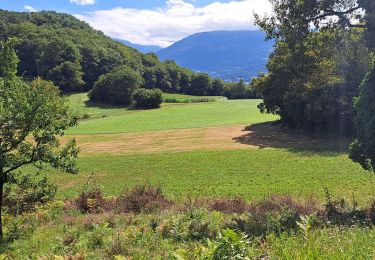
Randonnée A pied de 11,3 km à découvrir à Occitanie, Hautes-Pyrénées, Ouzous. Cette randonnée est proposée par marmotte65.
Description
départ du parking de l’église de ouzous.
Suivre le balisage en attendant les 14 lacets numérotes tous les chiffres pairs. belle balade a faire tout de même avec un minimum de condition physique, et préférence par beau temps.
Localisation
Pays :
France
Région :
Occitanie
Département/Province :
Hautes-Pyrénées
Commune :
Ouzous
Localité :
Unknown
Départ:(Dec)
Départ:(UTM)
735816 ; 4768383 (30T) N.
Commentaires
Randonnées à proximité
![Randonnée Marche Argelès-Gazost - Le Mont de Gez en circuit - Argelès Gazost - Photo](https://media.geolcdn.com/t/375/260/ext.jpg?maxdim=2&url=https%3A%2F%2Fservices.sitytrail.com%2FGeolivesWS%2FDownloadMedia.ashx%3FTrailID%3D172309%26Media%3D13627_4.jpg)
![Marche Marche](https://static1.geolcdn.com/sitytour/trail-icons/101.png)
Le Mont de Gez en circuit - Argelès Gazost
Marche
Moyen
(1)
Argelès-Gazost,
Occitanie,
Hautes-Pyrénées,
France
![](/images/other/stat-length.png)
11,8 km | 20 km-effort
4h 30min
![](https://static1.geolcdn.com/siteimages/upload/files/16400158638029165_repeat_loop_refresh_sync_direction_icon.png)
Oui
![Randonnée Marche Ségus - col du pré du roi par segus reconnu - Photo](https://media.geolcdn.com/t/375/260/8a292310-c3a3-4003-ab0e-617cb49dc561.jpg&format=jpg&maxdim=2)
![Marche Marche](https://static1.geolcdn.com/sitytour/trail-icons/101.png)
col du pré du roi par segus reconnu
Marche
Difficile
(1)
Ségus,
Occitanie,
Hautes-Pyrénées,
France
![](/images/other/stat-length.png)
10,4 km | 16,8 km-effort
3h 49min
![](https://static1.geolcdn.com/siteimages/upload/files/16400158638029165_repeat_loop_refresh_sync_direction_icon.png)
Oui
![Randonnée Vélo électrique Argelès-Gazost - CABALIROS 30 JUIN 2023 - Photo](https://media.geolcdn.com/t/375/260/d00efa13-e401-495e-87f8-f59eb1442703.jpg&format=jpg&maxdim=2)
![Vélo électrique Vélo électrique](https://static1.geolcdn.com/sitytour/trail-icons/205.png)
CABALIROS 30 JUIN 2023
Vélo électrique
Moyen
Argelès-Gazost,
Occitanie,
Hautes-Pyrénées,
France
![](/images/other/stat-length.png)
39 km | 57 km-effort
4h 47min
![](https://static1.geolcdn.com/siteimages/upload/files/16400158638029165_repeat_loop_refresh_sync_direction_icon.png)
Oui
![Randonnée Marche Argelès-Gazost - ARGELES La boucle de l arrieulat - Photo](https://media.geolcdn.com/t/375/260/cee8eb17-b22b-4615-9318-bf7446bdbe22.jpg&format=jpg&maxdim=2)
![Marche Marche](https://static1.geolcdn.com/sitytour/trail-icons/101.png)
ARGELES La boucle de l arrieulat
Marche
Difficile
Argelès-Gazost,
Occitanie,
Hautes-Pyrénées,
France
![](/images/other/stat-length.png)
10,3 km | 14,6 km-effort
3h 4min
![](https://static1.geolcdn.com/siteimages/upload/files/16400158638029165_repeat_loop_refresh_sync_direction_icon.png)
Oui
![Randonnée Marche Argelès-Gazost - ARGELES Mont de Gez G3 fait - Photo](https://media.geolcdn.com/t/375/260/653c1198-5439-4c4b-acf2-a53537be36e4.jpg&format=jpg&maxdim=2)
![Marche Marche](https://static1.geolcdn.com/sitytour/trail-icons/101.png)
ARGELES Mont de Gez G3 fait
Marche
Moyen
Argelès-Gazost,
Occitanie,
Hautes-Pyrénées,
France
![](/images/other/stat-length.png)
10,2 km | 18,3 km-effort
5h 39min
![](https://static1.geolcdn.com/siteimages/upload/files/16400158638029165_repeat_loop_refresh_sync_direction_icon.png)
Oui
![Randonnée Marche Ouzous - Ouzous pibeste-fait - Photo](https://media.geolcdn.com/t/375/260/ext.jpg?maxdim=2&url=https%3A%2F%2Fstatic1.geolcdn.com%2Fsiteimages%2Fupload%2Ffiles%2F1553511878bg_sport_marche.png)
![Marche Marche](https://static1.geolcdn.com/sitytour/trail-icons/101.png)
Ouzous pibeste-fait
Marche
Moyen
(1)
Ouzous,
Occitanie,
Hautes-Pyrénées,
France
![](/images/other/stat-length.png)
11,3 km | 22 km-effort
4h 29min
![](https://static1.geolcdn.com/siteimages/upload/files/16400158638029165_repeat_loop_refresh_sync_direction_icon.png)
Oui
![Randonnée Marche Ouzous - Pic du Pibeste - Photo](https://media.geolcdn.com/t/375/260/ext.jpg?maxdim=2&url=https%3A%2F%2Fstatic1.geolcdn.com%2Fsiteimages%2Fupload%2Ffiles%2F1553511878bg_sport_marche.png)
![Marche Marche](https://static1.geolcdn.com/sitytour/trail-icons/101.png)
Pic du Pibeste
Marche
Moyen
(1)
Ouzous,
Occitanie,
Hautes-Pyrénées,
France
![](/images/other/stat-length.png)
13 km | 25 km-effort
6h 9min
![](https://static1.geolcdn.com/siteimages/upload/files/16400158638029165_repeat_loop_refresh_sync_direction_icon.png)
Oui
![Randonnée Marche Salles - Escala du Prat du Rey - Photo](https://media.geolcdn.com/t/375/260/ext.jpg?maxdim=2&url=https%3A%2F%2Fstatic1.geolcdn.com%2Fsiteimages%2Fupload%2Ffiles%2F1553511878bg_sport_marche.png)
![Marche Marche](https://static1.geolcdn.com/sitytour/trail-icons/101.png)
Escala du Prat du Rey
Marche
Moyen
(1)
Salles,
Occitanie,
Hautes-Pyrénées,
France
![](/images/other/stat-length.png)
11,3 km | 22 km-effort
4h 24min
![](https://static1.geolcdn.com/siteimages/upload/files/16400158638029165_repeat_loop_refresh_sync_direction_icon.png)
Oui
![Randonnée Marche Ouzous - Pyrénées 2023 Jour 3 - Pic du Pibeste - Photo](https://media.geolcdn.com/t/375/260/fb027cac-9587-44ce-a7ce-c65dbfe35a1e.jpg&format=jpg&maxdim=2)
![Marche Marche](https://static1.geolcdn.com/sitytour/trail-icons/101.png)
Pyrénées 2023 Jour 3 - Pic du Pibeste
Marche
Moyen
Ouzous,
Occitanie,
Hautes-Pyrénées,
France
![](/images/other/stat-length.png)
11,5 km | 24 km-effort
7h 29min
![](https://static1.geolcdn.com/siteimages/upload/files/16400158638029165_repeat_loop_refresh_sync_direction_icon.png)
Oui