Randonnée V.T.T. Villeneuve-sur-Lot - Va - Photo
 mano74
mano74

Utilisateur

© OpenStreetMap contributors
Longueur
Longueur
13,6 km
Altitude max
Altitude max
169 m
Dénivelé positif
Dénivelé positif
214 m
Km-Effort
Km-Effort  
16,5 km
Altitude min
Altitude min
57 m
Dénivelé négatif
Dénivelé négatif
217 m
Boucle
Boucle
Non
Date de création :
2020-03-19 15:49:20.0
Dernière modification :
2020-03-19 16:36:08.915

(0 Avis)

V.T.T.
V.T.T.
46m
Difficulté : Facile

Scannez ce code QR pour ouvrir la randonnée dans l'application SityTrail

Application GPS de randonnée GRATUITE

Logo SityTrail SityTrail

IGN / Instituts géographiques

Télécharger SityTrail sur l'App Store Télécharger SityTrail sur Google Play

Logo SityTrail SityTrail World

Le monde est à vous

Télécharger SityTrail sur l'App Store Télécharger SityTrail sur Google Play Télécharger SityTrail sur Huawei AppGallery

À propos

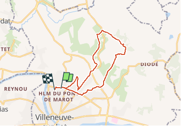
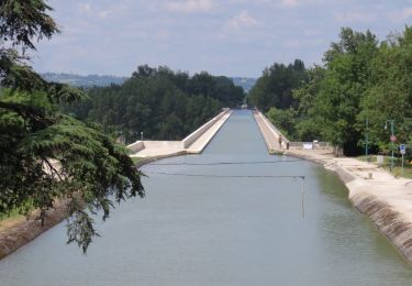
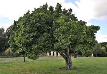
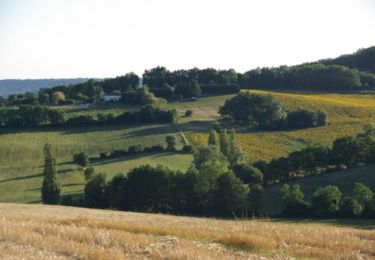
Randonnée V.T.T. de 13,6 km à découvrir à Nouvelle-Aquitaine, Lot-et-Garonne, Villeneuve-sur-Lot. Cette randonnée est proposée par mano74.

Profil altimétrique

Localisation

Pays :
France
Région :
Nouvelle-Aquitaine
Département/Province :
Lot-et-Garonne
Commune :
Villeneuve-sur-Lot
Localité :
Unknown
Départ:(Dec)
Départ:(UTM)
317665 ; 4921296 (31T) N.

Randonnées à proximité

Randonnée Marche Pujols - Pujols, panoramas sur les vallées du Lot et du Mail - Pays de la vallée du Lot - Photo
Marche
tracegps

Marche

Difficile
(1)
Pujols, Nouvelle-Aquitaine, Lot-et-Garonne, France
11,7 km | 17,3 km-effort
3h 15min
Oui
Randonnée A pied Pujols - Pujols - Vallée de la Mail - 10.5 - Photo
A pied
PRO

A pied

Facile
Pujols, Nouvelle-Aquitaine, Lot-et-Garonne, France
7,3 km | 11,3 km-effort
2h 33min
Oui
Randonnée A pied Pujols - Pujols - Petit-Tour - 5,5km - Photo
A pied
PRO

A pied

Facile
Pujols, Nouvelle-Aquitaine, Lot-et-Garonne, France
5 km | 7,4 km-effort
1h 40min
Non
Randonnée Marche Pujols - La balade de Pujols 47 - Photo
Marche
alainjoseph6

Marche

Très facile
Pujols, Nouvelle-Aquitaine, Lot-et-Garonne, France
7,7 km | 11,7 km-effort
3h 5min
Oui
Randonnée Vélo Villeneuve-sur-Lot - de Villeneuve sur Lot à Moissac en passant par Aiguillon - Photo
Vélo
destras

Vélo

Moyen
Villeneuve-sur-Lot, Nouvelle-Aquitaine, Lot-et-Garonne, France
129 km | 143 km-effort
6h 0min
Non
Randonnée Marche Bias - La balade de Senelles - Bias - Photo
Marche
tracegps

Marche

Facile
Bias, Nouvelle-Aquitaine, Lot-et-Garonne, France
4,4 km | 4,8 km-effort
1h 30min
Oui
Randonnée A pied Villeneuve-sur-Lot - Saint-Germain, l’autre colline de Villeneuve-sur-Lot - 10,3km - Photo
A pied
PRO

A pied

Facile
Villeneuve-sur-Lot, Nouvelle-Aquitaine, Lot-et-Garonne, France
10 km | 14,5 km-effort
3h 17min
Oui
Randonnée A pied Villeneuve-sur-Lot - Saint-Germain, aux portes de Villeneuve-sur-Lot - 4,2km - Photo
A pied
PRO

A pied

Facile
Villeneuve-sur-Lot, Nouvelle-Aquitaine, Lot-et-Garonne, France
4 km | 5,7 km-effort
1h 17min
Oui
Randonnée V.T.T. Villeneuve-sur-Lot - De Villeneuve sur Lot à Saint Aubin - Photo
V.T.T.
tracegps

V.T.T.

Difficile
(1)
Villeneuve-sur-Lot, Nouvelle-Aquitaine, Lot-et-Garonne, France
40 km | 51 km-effort
3h 0min
Oui


Fermer
Mes abonnements